This website works best with a newer web browser such as Chrome, Firefox, Safari or Microsoft Edge. Internet Explorer is not supported by this website.

3 consecutive days with Canadian wildfire smoke across much of the north-central US

With numerous wildfires burning across the boreal forest regions of Alberta/Saskatchewan/Manitoba during late May 2025, dense smoke began to move southward across much of the north-central US beginning on 30 May. GOES-19 (GOES-East) True Color RGB images along with the Aerosol Optical Depth (AOD) derived product from the CSPP GeoSphere site (above) showed the... Read More

Sequence of GOES-19 True Color RGB images and Aerosol Optical Depth derived product on 30 May [click to play animated GIF]

With numerous wildfires burning across the boreal forest regions of Alberta/Saskatchewan/Manitoba during late May 2025, dense smoke began to move southward across much of the north-central US beginning on 30 May. GOES-19 (GOES-East) True Color RGB images along with the Aerosol Optical Depth (AOD) derived product from the CSPP GeoSphere site (above) showed the areal coverage and transport of this wildfire smoke on 30 May.

For the most part, the majority of this smoke remained aloft — and only reduced the surface visibility (the number at the bottom of each Ceiling/Visibility plot, in statute miles) at a handful of sites across northern Minnesota, northern Wisconsin and eastern Iowa (below).

Sequence of GOES-19 Visible images and Aerosol Optical Depth derived product on 30 May, with Ceiling/Visibility observations plotted in cyan [click to play MP4 animation]

A Pilot Report over far northern Minnesota (below) indicated that smoke was reducing the visibility to 5 miles at an altitude of 5500 feet.

GOES-19 Visible image at 2011 UTC on 30 May, with cursor sampling of a Pilot Report over Minnesota [click to enlarge]

=========

On 31 May, GOES-19 True Color RGB and AOD imagery (below) revealed that some of the smoke was becoming entrained into the circulation of a compact area of mid-tropospheric low pressure that was moving southward from the Dakotas to Nebraska.

Sequence of GOES-19 True Color RGB images and Aerosol Optical Depth derived product on 31 May [click to play animated GIF]

Smoke became particularly dense just north of this low, as it descended into the boundary layer — and the surface visibility was reduced to 1-2 miles at several sites across North and South Dakota (below).

Sequence of GOES-19 Visible images and Aerosol Optical Depth derived product on 31 May, with Ceiling/Visibility observations plotted in cyan [click to play MP4 animation]

The depth of the smoke layer was notable — while the surface visibility was 2-1/2 miles at Watertown SD (KATY), a Pilot Report over that location indicated that haze was reducing the visibility to 5 miles at an altitude of 12,000 feet (below).

GOES-19 Visible image at 1826 UTC on 31 May, with cursor sampling of the surface report and a Pilot Report over Watertown SD [click to enlarge]

=========

Dense wildfire smoke persisted across much of the region on 01 June, as shown by GOES-19 True Color RGB and AOD imagery (below).

Sequence of GOES-19 True Color RGB images and Aerosol Optical Depth derived product on 01 June [click to play animated GIF]

The surface visibility restrictions were generally confined to the eastern Dakotas/Nebraska and western Minnesota/Iowa (below).

Sequence of GOES-19 Visible images and Aerosol Optical Depth derived product on 01 June, with Ceiling/Visibility observations plotted in cyan [click to play MP4 animation]

While the surface visibility was 5 miles at Sioux Falls SD (KFSD), a nearby Pilot Report noted that haze was restricting the visibility to 3 miles at an altitude of 2200 feet (below).

GOES-19 Visible image at 1456 UTC on 01 June, with cursor sampling of the surface report and a Pilot Report over Sioux Falls SD [click to enlarge]

View only this post Read Less

Tropical Storm Alvin forms in the eastern Pacific Ocean

Daily CSPP Geosphere imagery (direct link) showing 1710 UTC imagery from 25-29 May 2025, above, depict the slow organization and intensification of an area of disturbed weather south of Mexico (discussed here) as it became Tropical Storm Alvin, the first storm of the eastern Pacific Hurricane Season. This is the 4th Alvin... Read More

GOES-18 True Color Imagery at 1710 UTC, 25-29 May 2025 (Click to enlarge)

Daily CSPP Geosphere imagery (direct link) showing 1710 UTC imagery from 25-29 May 2025, above, depict the slow organization and intensification of an area of disturbed weather south of Mexico (discussed here) as it became Tropical Storm Alvin, the first storm of the eastern Pacific Hurricane Season. This is the 4th Alvin storm in the tropical east Pacific, following ones in 2019 (that was named on June 26th, strengthened to a hurricane, and was present for almost 4 days), 2013 (that was named on May 15th and remained a tropical storm during its short life) and 2007 (that was named on May 28th and remained a tropical storm). The 2025 version of Alvin is not forecast to make landfall; it is forecast to move north and dissipate over the weekend.

Scatterometry data captured from this KNMI website, below, shows two overpasses early on 29 May 2025, one from HY-2B and one from Metop-B. A closed circulation center and tropical storm-force winds are apparent.

Scatterometry plots from HY-2C (1250 UTC) and Metop-B (1550 UTC) over Alvin on 29 May 2025 (Click to enlarge)

Upper-level water vapor imagery, below, shows the cold convective cloud tops associated with the developing system. Alvin is embedded within a moist airmass. The favorable environment suggests slow strengthening as indicated in the forecast.

GOES-18 Upper Level Water Vapor infrared (Band 8, 6.19 µm) imagery, 1430-1920 UTC on 29 May 2025. The 1500 UTC NHC forecast path for Alvin is indicated (Click to enlarge)

The National Hurricane Center is issuing advisories on Alvin every 6 hours here.

View only this post Read Less

Pyrocumulonimbus clouds spawned by a wildfire in British Columbia

10-minute Full Disk scan GOES-18 (GOES-West) “Clean” Infrared Window (10.3 µm) images and “Red” Visible (0.64 µm) images with an overlay of the FDCA Fire Mask derived product (above) showed that a large wildfire north of Fort Nelson (CYYE) in far northeastern British Columbia produced a series of ~3 pyrocumulonimbus... Read More

10-minute GOES-18 Clean Infrared Window (10.3 µm, left) images and Red Visible (0.64 µm) images + Fire Mask derived product (right), from 2000 UTC on 28 May to 0500 UTC on 29 May [click to play MP4 animation]

10-minute Full Disk scan GOES-18 (GOES-West) “Clean” Infrared Window (10.3 µm) images and “Red” Visible (0.64 µm) images with an overlay of the FDCA Fire Mask derived product (above) showed that a large wildfire north of Fort Nelson (CYYE) in far northeastern British Columbia produced a series of ~3 pyrocumulonimbus (pyroCb) clouds on 28 May 2025. The pyroCb clouds exhibited cloud-top 10.3 µm infrared brightness temperatures (IRBTs) in the -40s C (denoted by shades of blue to cyan) — a necessary condition to be classified as a pyroCb — beginning at 0010 UTC on 29 May. The coldest pyroCb cloud-top IRBT was -52.57ºC at 0320 UTC on 29 May (below).

GOES-18 Clean Infrared Window (10.3 µm, left) image and Red Visible (0.64 µm) image + Fire Mask derived product (right), with a cursor sample of the coldest cloud-top infrared brightness temperature at 0320 UTC on 29 May [click to enlarge]

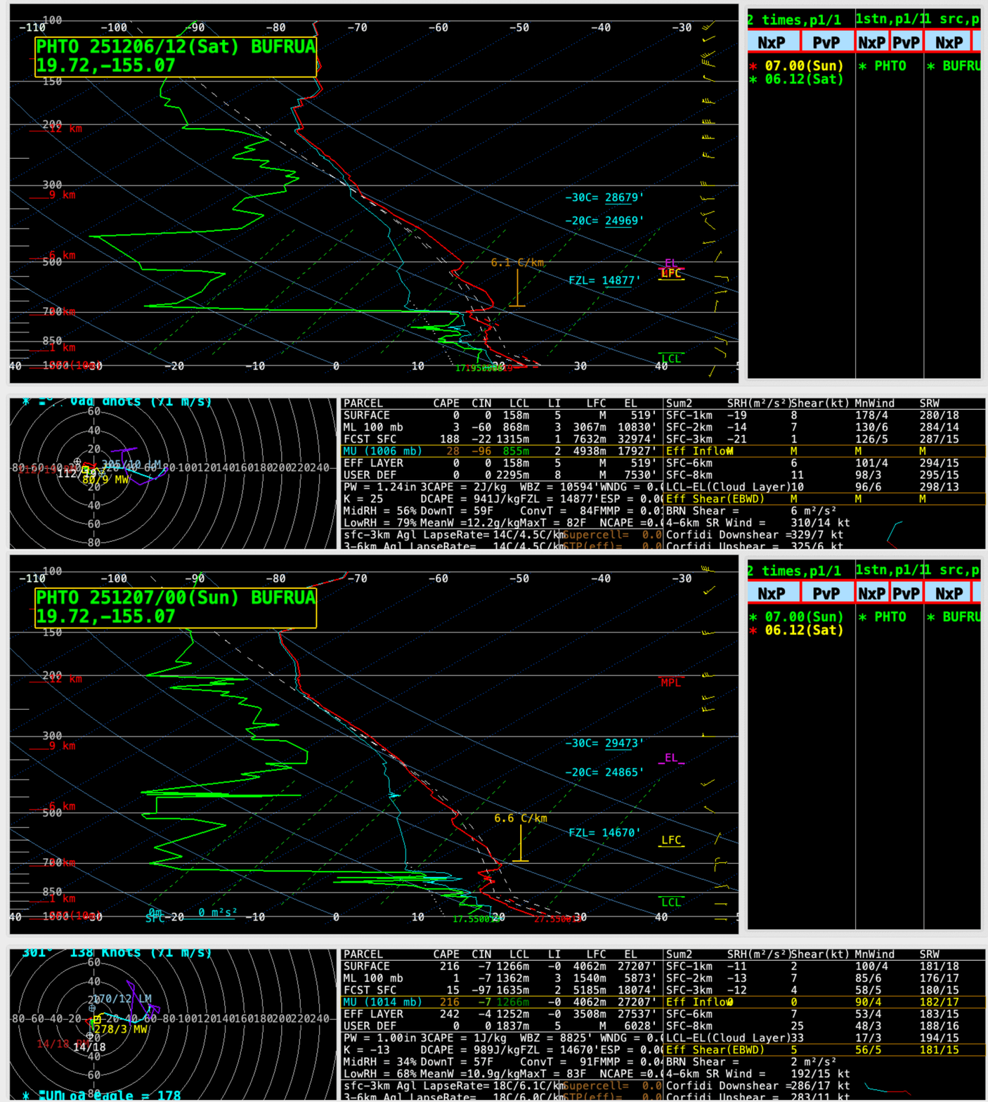
According to rawinsonde data from Fort Nelson, British Columbia at 0000 UTC on 29 May (below), the coldest pyroCb IRBT corresponded to an altitude around 11.1 km.

Plot of rawinsonde data from Fort Nelson, British Columbia at 0000 UTC on 29 May [click to enlarge]

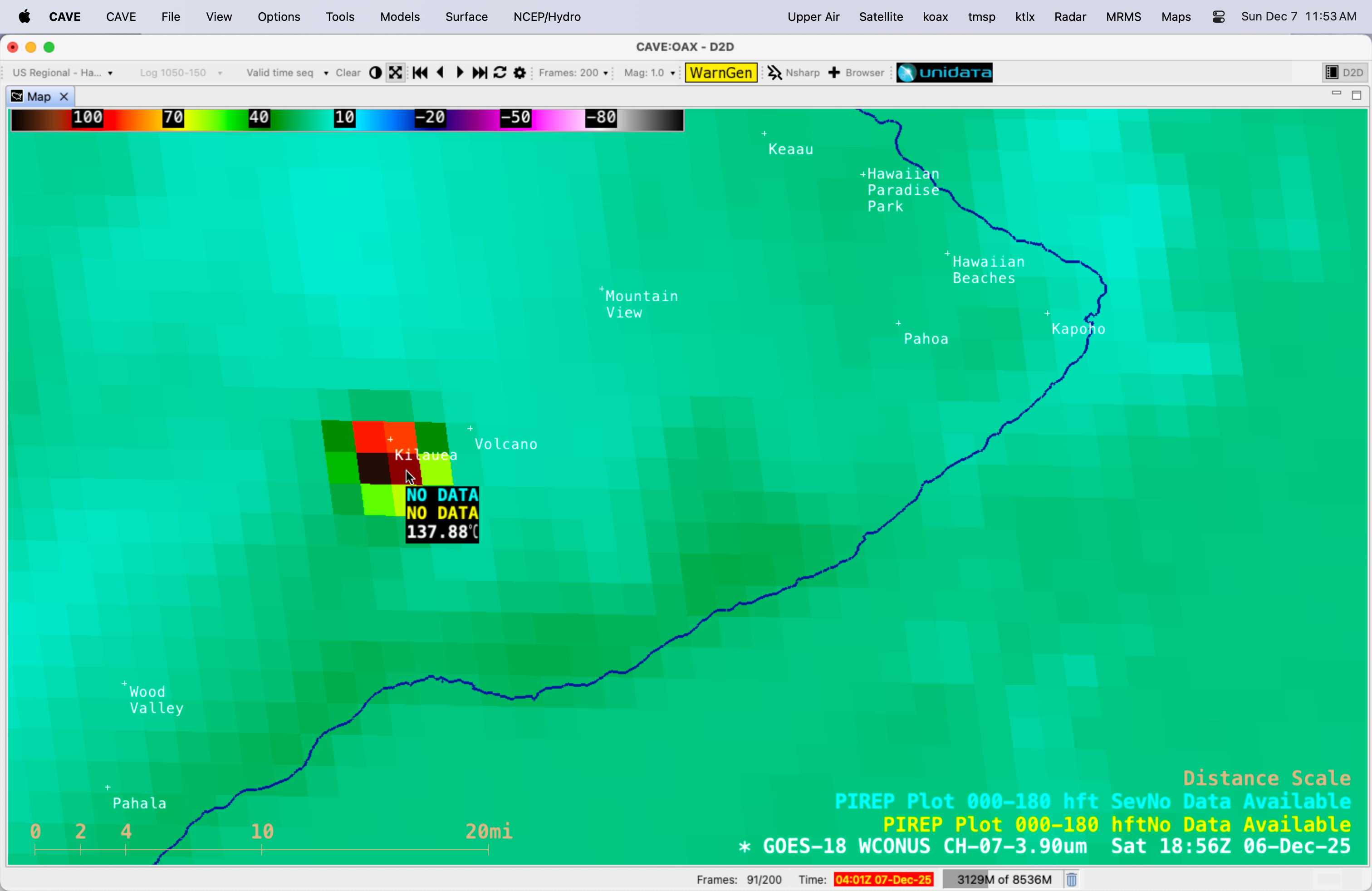
This large wildfire burned very hot, exhibiting Shortwave Infrared 3.9 µm brightness temperature values of 137.88ºC — the saturation temperature of GOES-18 ABI Band 7 detectors — for 2.5 hours, from 2210 UTC on 28 May (2 hours prior to the formation of the first pyroCb) until 0040 UTC on 29 May (below).

Cursor sample of GOES-18 Shortwave Infrared (3.9 µm) brightness temperature (left panel) at 2210 UTC on 28 May [click to enlarge]

Cursor sample of GOES-18 Shortwave Infrared (3.9 µm) brightness temperature (left panel) at 0040 UTC on 29 May [click to enlarge]

This wildfire also made a significant run to the NNW in ~13 hours, as seen in a comparison of VIIRS Fire Radiative Power displayed using RealEarth (below).

VIIRS Fire Radiative Power at 2138 UTC on 28 May and 1039 UTC on 29 May [click to enlarge]

The NNW run of the wildfire was also apparent in a 14-hour animation of Next Generation Fire System (NGFS) fire detection polygons (below).

10-minute GOES-18 Infrared Window images with an overlay of NGFS Fire Detection polygons, from 1900 UTC on 28 May to 0900 UTC on 29 May [click to play MP4 animation]

===== 29 May Update =====

10-minute GOES-19 True Color RGB images, from 1100 UTC on 29 May to 0050 UTC on 30 May [click to play MP4 animation]

During the following daytime hours, GOES-19 (GOES-East) True Color RGB images (above) revealed a long ribbon of brownish-gray smoke-laden pyroCb ice cloud that was arcing eastward across the Northwest Territories then curving southward over Nunavut, Manitoba and Saskatchewan as the leading edge approached the Canada/US border.

View only this post Read Less

Comparing GOES and VIIRS NGFS detections over Canada

The slider below compares two different NGFS detections over the Canadian Plains: a VIIRS image (created using data from the direct broadcast antenna at CIMSS) and a GOES-18 image. The NGFS Microphysics looks slightly different between the two because of different view angles and slightly different channel characteristics between the VIIRS... Read More

The slider below compares two different NGFS detections over the Canadian Plains: a VIIRS image (created using data from the direct broadcast antenna at CIMSS) and a GOES-18 image. The NGFS Microphysics looks slightly different between the two because of different view angles and slightly different channel characteristics between the VIIRS and GOES bands used. Note the far better spatial resolution with the VIIRS imagery however. The smoke plume is thick enough in both depictions that it has a presence in the RGB. This GOES-East true-color image (from the CSPP Geosphere site) shows the thickness and extent of the smoke plume later in the day on 28 May.

View only this post Read Less