This website works best with a newer web browser such as Chrome, Firefox, Safari or Microsoft Edge. Internet Explorer is not supported by this website.

Grassland fire in South Dakota

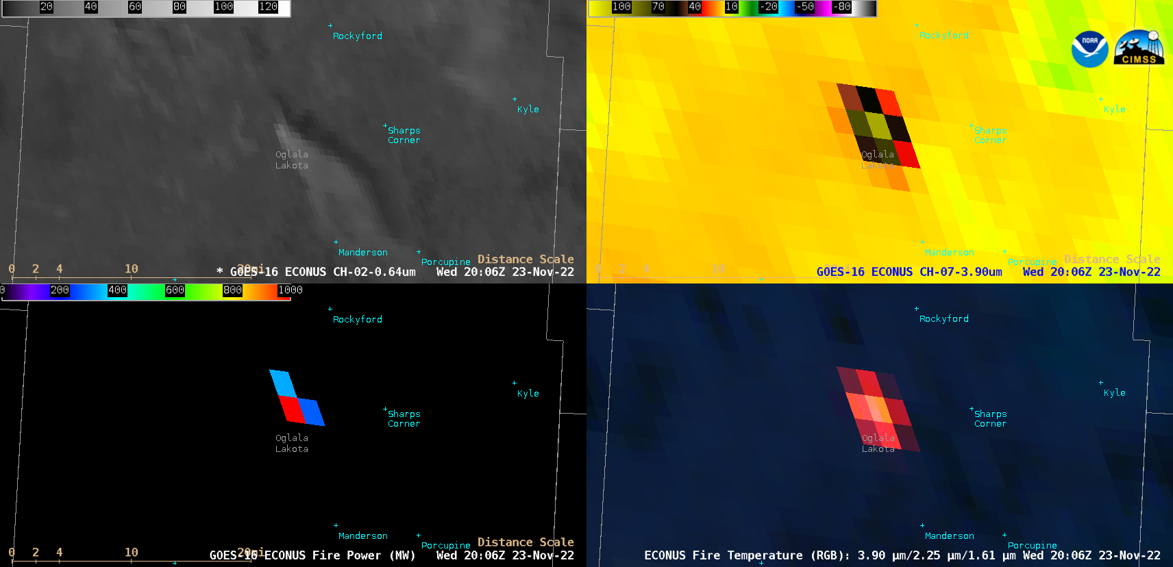
5-minute GOES-16 (GOES-East) “Red” Visible (0.64 µm), Shortwave Infrared (3.9 µm), Fire Power derived product and Fire Temperature RGB images (above) displayed signatures of the wind-driven “Turkey Day” grassland fire in Oglala Lakota County in southwestern South Dakota on 23 November 2022. Peak 3.9 µm infrared brightness temperature (102.53ºC) and Fire Power (1570.84 MW) values were... Read More

GOES-16 “Red” Visible (0.64 µm, top left), Shortwave Infrared (3.9 µm, top right), Fire Power (bottom left) and Fire Temperature RGB (bottom right) images [click to play animated GIF | MP4]

5-minute GOES-16 (GOES-East) “Red” Visible (0.64 µm), Shortwave Infrared (3.9 µm), Fire Power derived product and Fire Temperature RGB images (above) displayed signatures of the wind-driven “Turkey Day” grassland fire in Oglala Lakota County in southwestern South Dakota on 23 November 2022. Peak 3.9 µm infrared brightness temperature (102.53ºC) and Fire Power (1570.84 MW) values were seen at 2006 UTC (the Fire Power derived product is a component of the GOES Fire Detection and Characterization Algorithm FDCA). Clouds began to move over the fire late in the day, thereby masking its thermal signature.

A toggle between Suomi-NPP VIIRS True Color RGB and False Color RGB images valid at 2016 UTC (below) provided a higher-resolution view of the narrow, dark burn scar as well as the smoke plume; in the False Color image, the hottest signature at the leading (southern) edge of the fire showed up as brighter shades of pink. Note how the fire’s burn scar initially moved eastward about 1 mile, but then  jogged toward the southeast as surface winds with gusts in the 20-26 knot range (Pine Ridge SD observations) abruptly shifted from westerly to northwesterly (in the wake of a cold frontal passage). The data to produce these VIIRS images were downloaded and processed using the SSEC/CIMSS Direct Broadcast ground station.

Suomi-NPP VIIRS True Color RGB and False Color RGB images, valid at 2016 UTC [click to enlarge]

View only this post Read Less

Sun glint, light winds, and sea surface temperatures

The animation of GOES-17 visible imagery (Band 2, 0.64 µm), above, (created at the CSPP Geosphere site) shows the characteristic signal of Sun Glint — the moving bright region. Sun glint (also discussed on this blog here, here, here, here and — for moonglint: here!) occurs when radiation from the Sun reflects... Read More

GOES-17 Band 2 Visible (0.64 µm), 2350 UTC on 17 November 2022 to 0300 UTC on 18 November

The animation of GOES-17 visible imagery (Band 2, 0.64 µm), above, (created at the CSPP Geosphere site) shows the characteristic signal of Sun Glint — the moving bright region. Sun glint (also discussed on this blog here, here, here, here and — for moonglint: here!) occurs when radiation from the Sun reflects off the ocean surface and is detected by the satellite sensor, in this case the GOES-17 ABI. On the day displayed (17 November), this reflection was pronounced because of light winds and flat seas. The flatter the sea, the more pronounced and intense the reflection; a useful analogy is flat and wrinkled aluminum foil for flat and wavy seas, respectively. You would expect to see a more concentrated reflection off the flat aluminum foil.

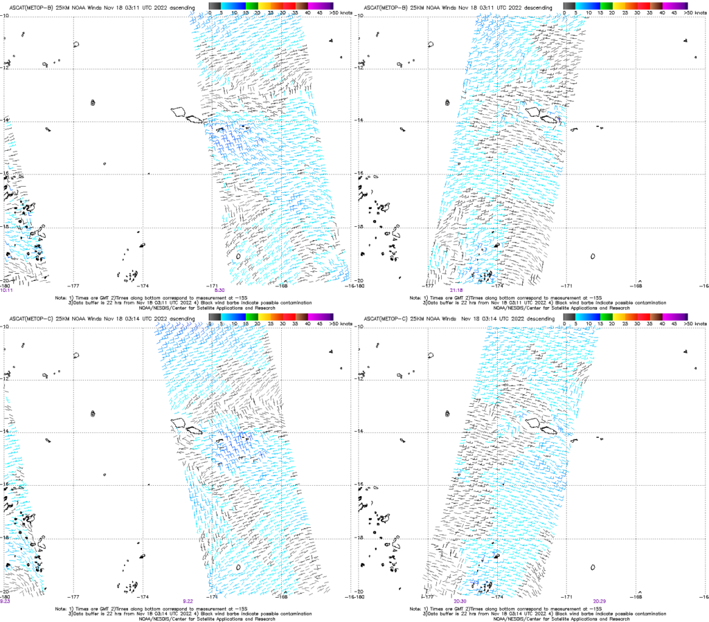
How light were the winds? MetopB and MetopC scatterometer winds, shown in tandem below, from 17 November (from this site), show very light winds to the northeast of the Samoan islands.

ASCAT winds from MetopB (top row) and MetopC (bottom row) on 17 November 2022. Ascending pass (note times near 0900 UTC in purple at the bottom of the imagery) on left, descending pass (times near 2100 UTC) on right (Click to enlarge)

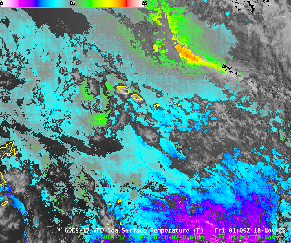
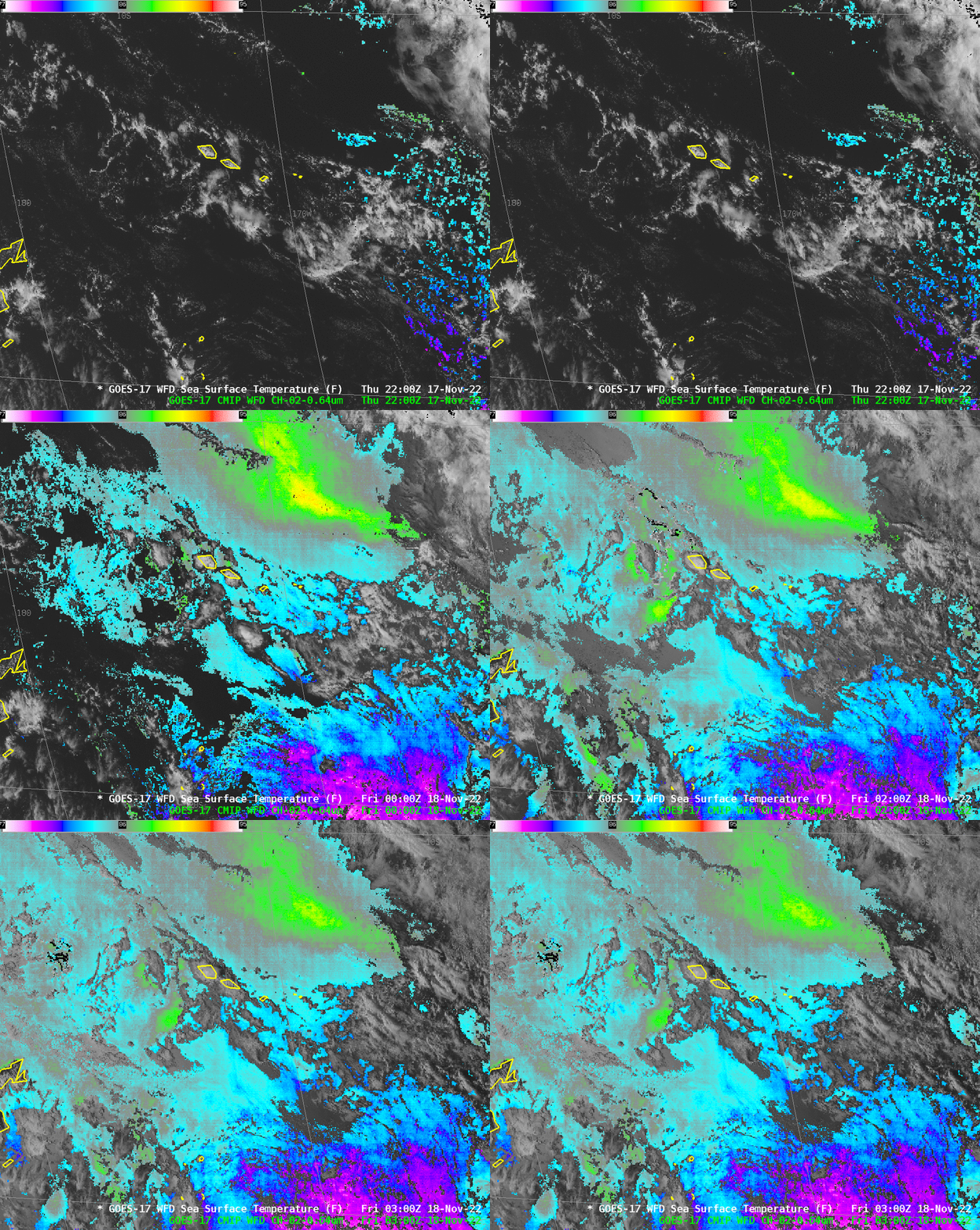
Conditions that support concentrated sun glint will also affect the computed sea-surface temperatures (SSTs). That is shown below. Note how warm the SSTs become (>93oF at 0100 UTC)!

GOES-17 Derived Sea Surface Temperatures (SSTs) under GOES-17 Band 2 Visible (0.64 µm) imagery, hourly from 2200 UTC 17 November to 0300 UTC 18 November 2022 (Click to enlarge)

Should you believe the very warm SST values? If the seas are flat and winds are near calm, the surface skin of the ocean can become very warm, because mixing in the upper inches of the ocean is minimal absent forcing by winds and waves. The SST algorithm incorporates information from the shortwave IR band (Band 7 on ABI at 3.9 µm) and does account for sun glint (see pp 27-28 in the Algorithm Theoretical Basis Document). The image below shows 0100 UTC Visible (0.64 µm) on the left, Shortwave IR (3.9 µm) in the middle and computed SSTs on the right.

GOES-17 VIsible imagery (0.64 µm), left, shortwave infrared (3.9 µm), center and computed SSTs (right), all at 0100 UTC on 18 November 2022 (click to enlarge)

In winds are very light, expect to see warmer SSTs than in surrounding waters where winds are stronger (and vertical mixing in the ocean is therefore greater). However, pay attention if an increase in SSTs accompanies sun glint. The difference of 5oF shown above is likely contamination from reflected solar insolation.

View only this post Read Less

Anomalously-strong jet streak over the Mid-Atlantic states

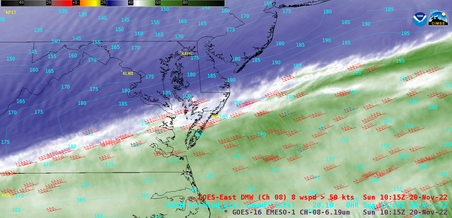
As an anomalously-strong upper-tropospheric jet streak was moving across the Mid-Atlantic region on 20 November 2022, GOES-16 (GOES-East) Upper-level Water Vapor (6.2 µm) images (above) displayed numerous 6.2 µm Derived Motion Wind (DMW) vectors having speeds of 190 knots and higher — with the jet streak axis passing just to the north of the Wallops,... Read More

GOES-16 Upper-level Water Vapor (6.2 µm) images, with 6.2 µm Derived Motion Wind vectors plotted in red, contours of RAP40 model Maximum Wind isotachs plotted in cyan and rawinsonde sites indicated in yellow [click to play animated GIF | MP4]

As an anomalously-strong upper-tropospheric jet streak was moving across the Mid-Atlantic region on 20 November 2022, GOES-16 (GOES-East) Upper-level Water Vapor (6.2 µm) images (above) displayed numerous 6.2 µm Derived Motion Wind (DMW) vectors having speeds of 190 knots and higher — with the jet streak axis passing just to the north of the Wallops, Virginia rawinsonde site (KWAL). Derived Motion Wind speeds as high as 201 knots and 202 knots were seen shortly before the launch of the 12 UTC Wallops sounding.

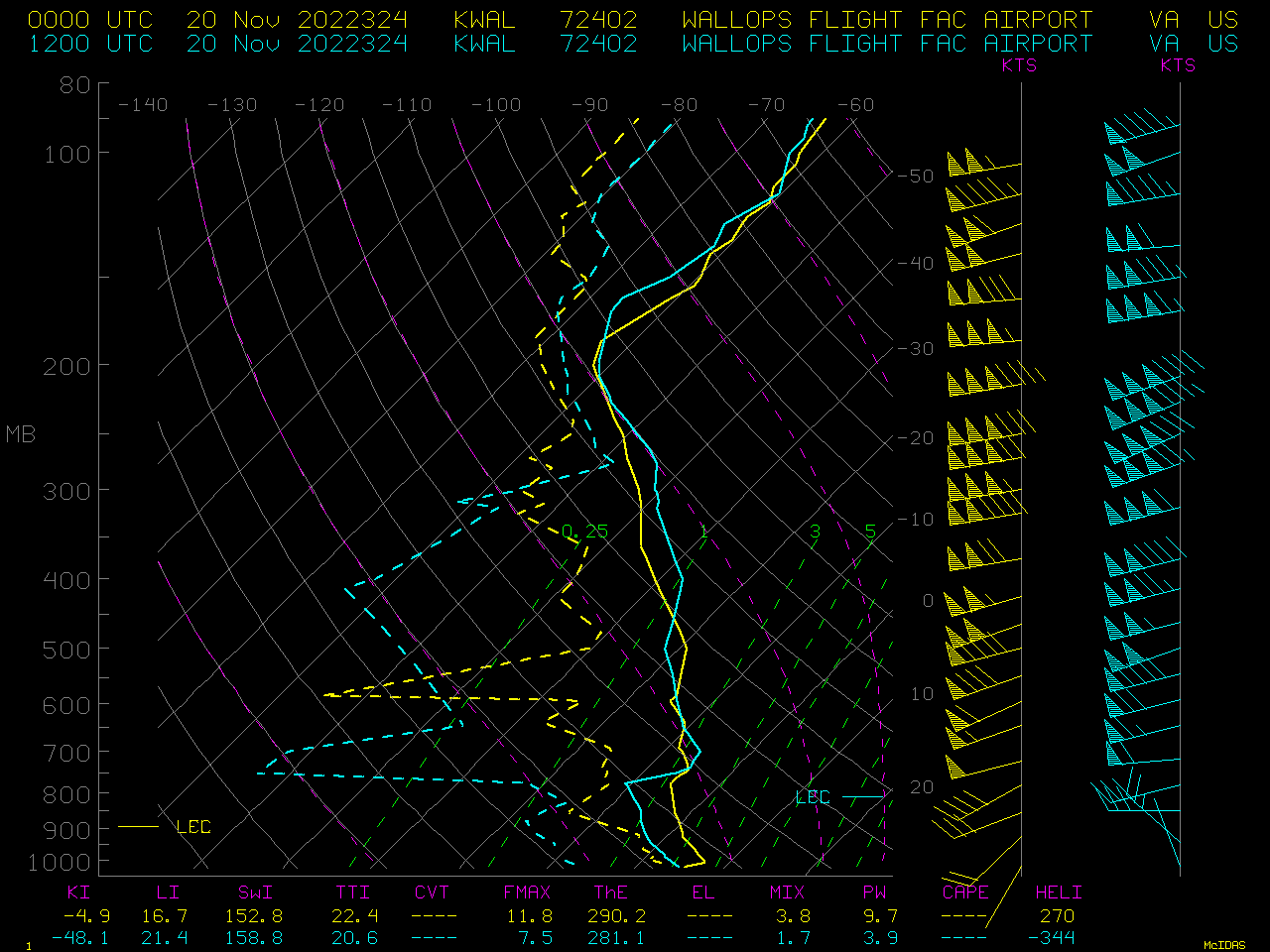
Plots of Wallops, Virginia rawinsonde data at 00 UTC and 12 UTC on 20 November (below) showed that the maximum wind speeds were at the 213 hPa level (187.8 knots) at 00 UTC and the 206 hPa level (189.8 knots) at 12 UTC.

Plots of Wallops, Virginia rawinsonde data at 00 UTC and 12 UTC on 20 November [click to enlarge]

A plot of 250 hPa wind speed climatology for the Wallops rawinsonde site (from SPC) includes the 12 UTC value on 20 November 2022 (shown by the black circle) — which indicated that the 183-knot value measured during that 12 UTC sounding ascent was the fastest 250 hPa wind speed for the month of November at that site.

Plot of 250 hPa wind speed climatology for the Wallops rawinsonde site, with the 12 UTC value on 20 November 2022 shown by the black circle [click to enlarge]

View only this post Read Less

Lake effect snow downwind of Lake Erie

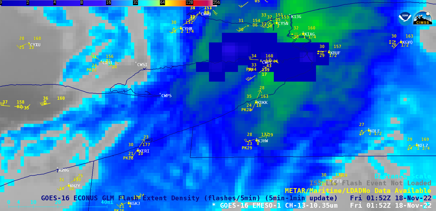
1-minute Mesoscale Domain Sector GOES-16 “Clean” Infrared Window (10.3 µm) images (above) include an overlay of GLM Flash Extent Density — which showed rapidly-cooling cloud-top infrared brightness temperatures (and intermittent lightning) over the eastern half of  Lake Erie, associated with the initial impulse of lake effect snow (LES) immediately downwind of the lake... Read More

GOES-16 “Clean” Infrared Window (10.3 µm) images, with an overlay of GLM Flash Extent Density [click to play MP4 animation]

1-minute Mesoscale Domain Sector GOES-16 “Clean” Infrared Window (10.3 µm) images (above) include an overlay of GLM Flash Extent Density — which showed rapidly-cooling cloud-top infrared brightness temperatures (and intermittent lightning) over the eastern half of  Lake Erie, associated with the initial impulse of lake effect snow (LES) immediately downwind of the lake after sunset on 17 November 2022. Snowfall rates quickly ramped up to 3 inches per hour at Buffalo (station identifier KBUF), with lightning reported. Along the north shore of Lake Erie, about 20 miles west of Buffalo, a peak wind gust of 60 knots was recorded at Port Colborne, Ontario (station identifier CWPC) at 0211 UTC on 18 November.

In the wake of this initial impulse, a dominant LES band became established along the axis of Lake Erie, which persistent during the entire night and into the following morning — snowfall accumulations were as high as 36.0 inches by 1530 UTC (10:30 AM EST).

After sunrise on 18 November, 1-minute GOES-16 Day Cloud Phase Distinction RGB images (below) indicated that much of the dominant LES band had cloud tops of mixed phase (supercooled water droplet + ice crystal) or glaciated phase (shades of yellow to green). By 2100 UTC (4:00 PM EST) on 18 November, the highest snowfall accumulations had reached 54 inches at Orchard Park just south of Buffalo.
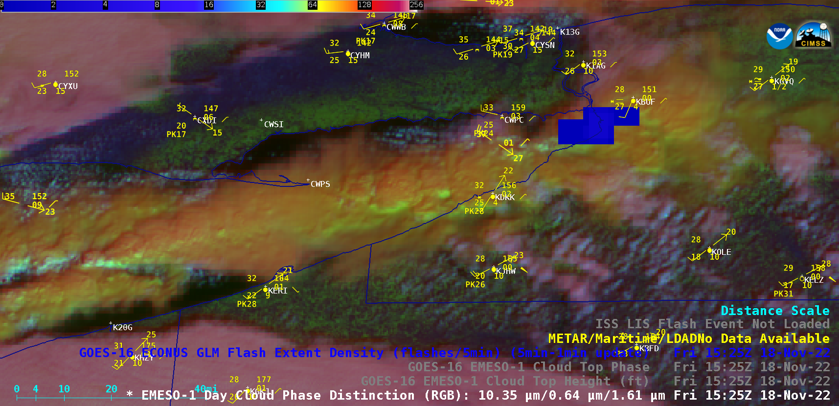
GOES-16 Day Cloud Phase Distinction RGB images, with an overlay of GLM Flash Extent Density [click to play animated GIF | MP4]

A toggle between Suomi-NPP VIIRS True Color RGB and False Color RGB images (below) depicted the broad LES band at 1828 UTC. The VIIRS data used to create these images were acquired and processed using the SSEC/CIMSS Direct Broadcast ground station.
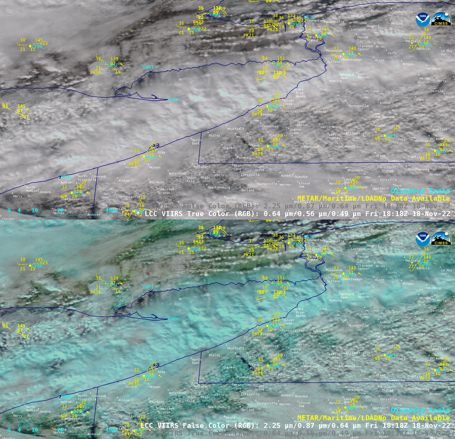
Suomi-NPP VIIRS True Color RGB and False Color RGB images, valid at 1828 UTC [click to enlarge]

The GOES-16 Cloud Top Phase derived product (below) confirmed the Mixed Phase nature (darker green) of much of the LES band.
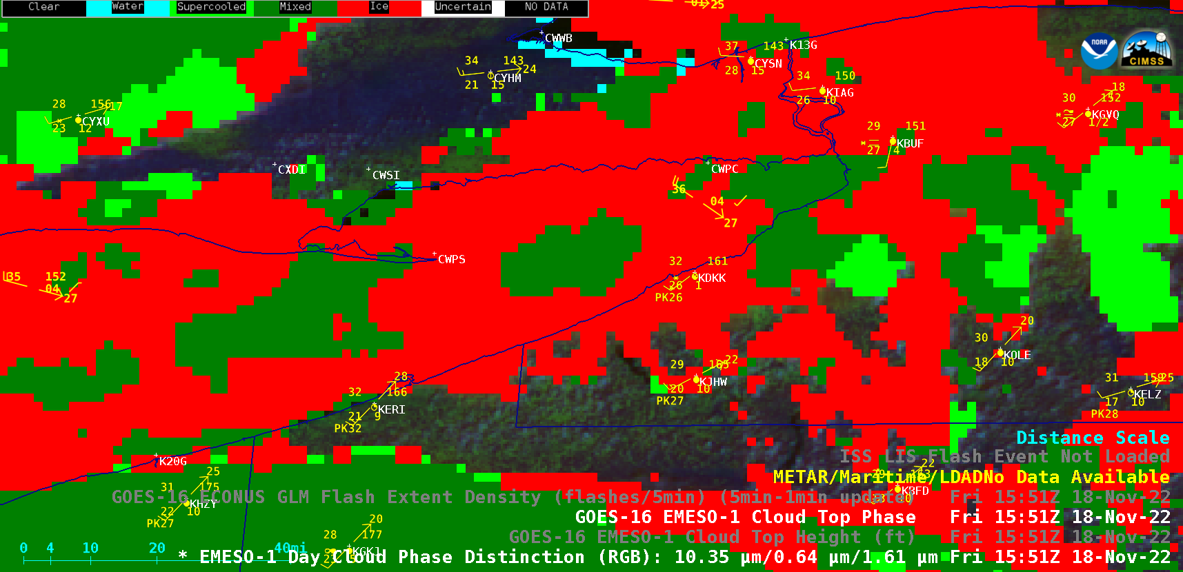
GOES-16 Cloud Top Phase derived product [click to play animated GIF | MP4]

After sunset on 18 November, GOES-16 Infrared images (below) showed that while the Lake Erie LES band was not as well-defined as earlier in the day, it still persisted (with isolated brief periods of lightning). By 0000 UTC on 19 November (7 PM EST on 18 November), snowfall accumulations had reached 66 inches at Orchard Park.
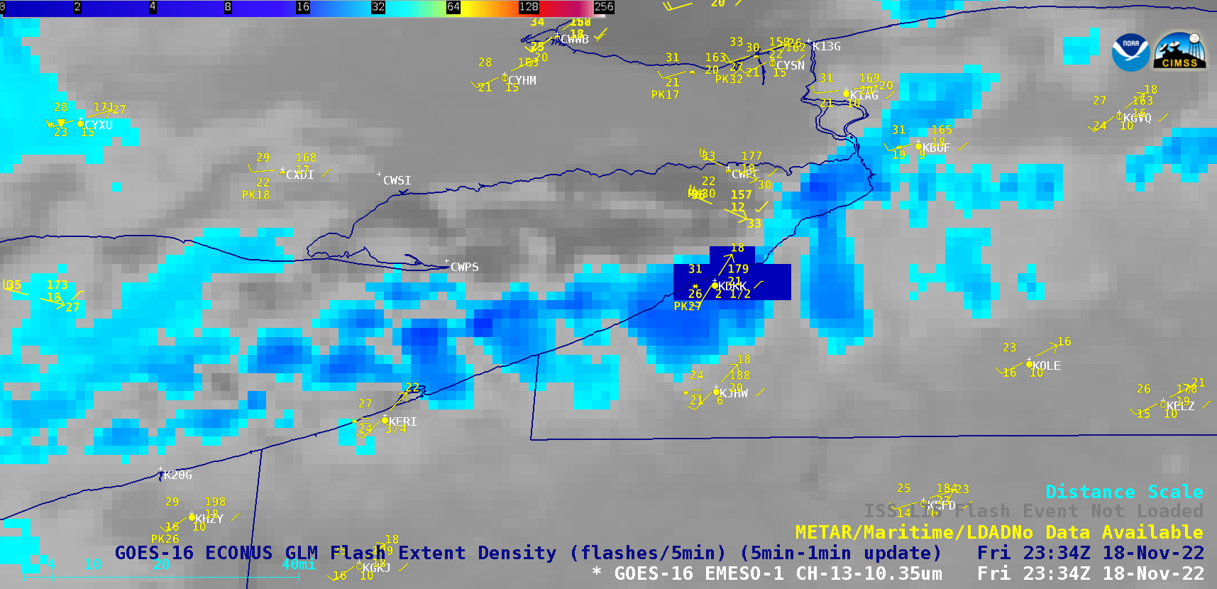
GOES-16 “Clean” Infrared Window (10.3 µm) images, with an overlay of GLM Flash Extent Density [click to play animated GIF | MP4]

===== 19 November Update =====
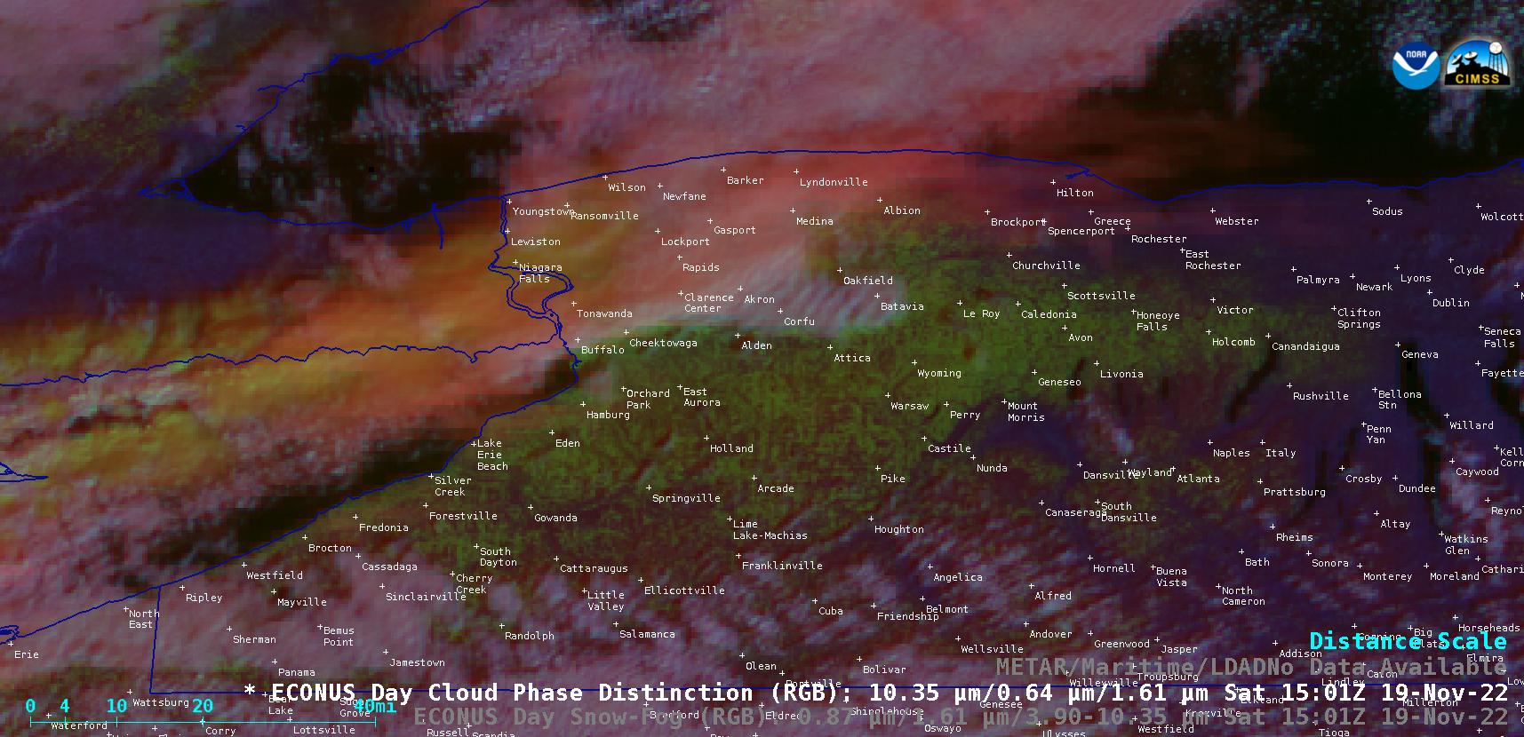
GOES-16 Day Snow-Fog RGB and Day Cloud Phase Distinction RGB images [click to play animated GIF | MP4]

Breaks in the cloud cover on the morning of 19 November provided a partial glimpse of the snow cover that resulted from this LES event — appearing as shades of red in the GOES-16 Day Snow-Fog RGB images, and shades of green in the Day Cloud Phase Distinction RGB images — which extended into the western Finger Lakes region of western New York. Snowfall accumulations were as high as 77.0 inches at Orchard Park.

=====

A list of storm total snowfall amounts from this multi-day (16-20 November) LES event is available here.

View only this post Read Less