![GOES-17 “Red” Visible (0.64 µm, top left), Shortwave Infrared (3.9 µm, top right), Fire Temperature RGB + GLM Flash Extent Density (bottom left) and “Clean” Infrared Window (10.35 µm, bottom right) [click to play animation | MP4]](https://cimss.ssec.wisc.edu/satellite-blog/images/2020/09/norcal_4p-20200909_104425.png)
GOES-17 “Red” Visible (0.64 µm, top left), Shortwave Infrared (3.9 µm, top right), Fire Temperature RGB + GLM Flash Extent Density (bottom left) and “Clean” Infrared Window (10.35 µm, bottom right) [click to play animation | MP4]
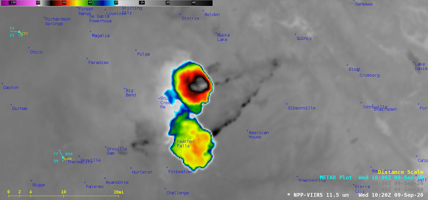
1-minute
Mesoscale Domain Sector GOES-17
(GOES-West) “Red” Visible (
0.64 µm), Shortwave Infrared (
3.9 µm),
Fire Temperature Red-Green-Blue (RGB) +
GLM Flash Extent Density (FED) and “Clean” Infrared Window (
10.35 µm) images
(above) showed the formation of a pyrocumulonimbus (pyroCb) cloud over the Bear Fire (part of the
North Complex) in Northern California on
09 September 2020. The coldest cloud-top infrared brightness temperatures were -61.4
ºC; no GLM-detected lightning activity was seen with this pyroCb.
A comparison of Suomi NPP VIIRS Day/Night Band (0.7 µm), Shortwave Infrared (3.74 µm) and Infrared Window (11.45 µm) images (below) displayed the initial 2 pyroCb cloud pulses shortly after their formation. Side-illumination from the Moon (which was in the Waning Gibbous phase, at 59% of Full) allowed for a distinct shadow to be cast northwest of the colder/taller pyroCb pulse — and the pyroCb clouds exhibited a darker appearance than the layer of low-altitude smoke to the west, likely due to very high amounts of fresh smoke contained within the rapidly-rising cloud turrets.
![Suomi NPP VIIRS Day/Night Band (0.7 µm), Shortwave Infrared (3.74 µm) and Infrared Window (11.45 µm) images [click to enlarge]](https://cimss.ssec.wisc.edu/satellite-blog/images/2020/09/200909_1020utc_suomiNPP_viirs_infrared_dayNightBand_shortwaveInfrared_Bear_Fire_CA_pyroCb_anim.gif)
Suomi NPP VIIRS Day/Night Band (0.7 µm), Shortwave Infrared (3.74 µm) and Infrared Window (11.45 µm) images [click to enlarge]
A toggle between time-matched Infrared Window images of the Bear Fire pyrocumulonimbus cloud from Suomi NPP (SNPP) and GOES-17 (below) highlighted the differences in spatial resolution — 375-m with SNPP VIIRS, vs 2-km (at satellite sub-point) with GOES-17 ABI — and the parallax displacement inherent with GOES-17 imagery at that location (17 km for a 15.2-km tall cloud top). The coldest cloud-top infrared brightness temperature was -76.2ºC with SNPP, vs -59.9ºC with GOES-17 (identical color enhancements were applied to both images).
![Infrared Window images from Suomi NPP (11.45 µm) and GOES-17 (11.45 µm) [click to enlarge]](https://cimss.ssec.wisc.edu/satellite-blog/images/2020/09/200909_1028utc_suomiNPP_goes17_infrared_Bear_Fire_pyroCb_CA_anim.gif)
Infrared Window images from Suomi NPP (11.45 µm) and GOES-17 (10.35 µm) [click to enlarge]
GOES-17 True Color Red-Green-Blue (RGB) images created using
Geo2Grid (below) showed the southward drift of the high-altitude pyroCb cloud material during the day, along with widespread dense smoke that covered much of California at lower altitudes.
![GOES-17 True Color RGB images [click to pay animation | MP4]](https://cimss.ssec.wisc.edu/satellite-blog/images/2020/09/GOES-17_ABI_RadC_true_color_2020253_150117Z.png)
GOES-17 True Color RGB images [click to pay animation | MP4]