
GOES-16 “Red” Visible (0.64 µm) images, with SPC storm reports plotted in red [click to play MP4 animation]
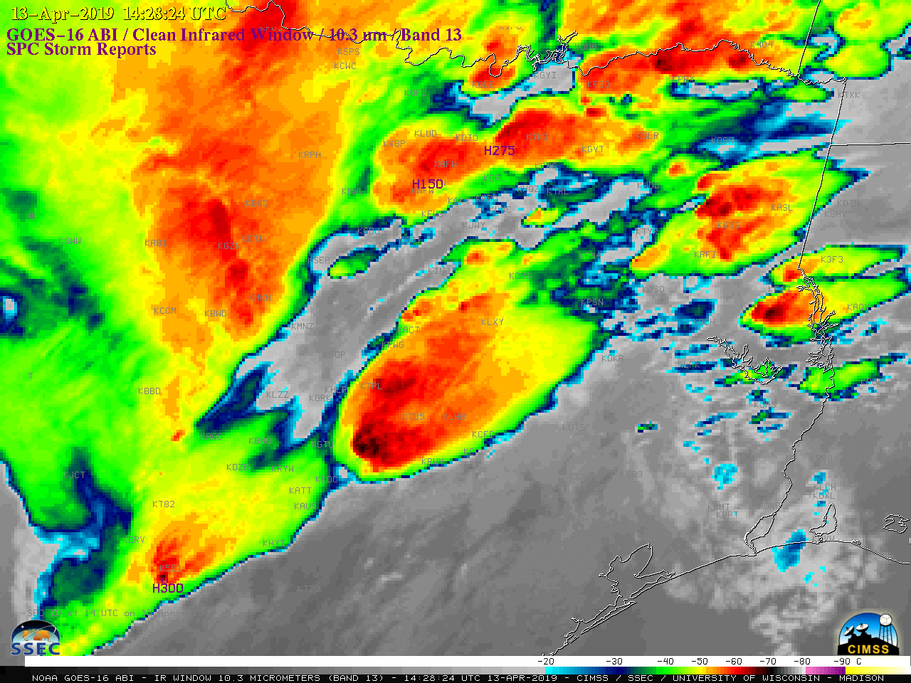
An outbreak of severe weather began in eastern Texas on the morning of
13 April 2019, where thunderstorms produced hail up to 3.0 inches in diameter, tornadoes and damaging winds (
SPC storm reports). 1-minute
Mesoscale Domain Sector GOES-16 “Red” Visible (
0.64 µm) images
(above) showed the clusters of thunderstorms that developed as a surface low and associated frontal boundaries moved eastward (
surface analyses). The corresponding GOES-16 “Clean” Infrared Window (
10.3 µm) images
(below) revealed numerous overshooting tops with infrared brightness temperatures as cold as -70 to -75ºC. In addition, the storm producing 3.0-inch hail and damaging winds at 1428 UTC exhibited an
Above-Anvil Cirrus Plume (
Visible/Infrared toggle).
![GOES-16 "Clean" Infrared Window (10.3 µm) images, with SPC storm reports plotted in purple [click to play MP4 animation]](https://cimss.ssec.wisc.edu/satellite-blog/wp-content/uploads/sites/5/2019/04/G16_IR_NOGLM_TX_SVR_13APR2019_2019103_142824_GOES-16_0001PANEL.GIF)
GOES-16 “Clean” Infrared Window (10.3 µm) images, with SPC storm reports plotted in purple [click to play MP4 animation]
A comparison of Terra MODIS Visible (0.65 µm) and Infrared Window (11.0 µm) images at 1650 UTC is shown below.
![Terra MODIS Visible (0.65 µm) and Infrared Window (11.0 µm) images [click to enlarge]](https://cimss.ssec.wisc.edu/satellite-blog/wp-content/uploads/sites/5/2019/04/190413_1650uc_terra_modis_visible_infrared_spcStormReports_anim.gif)
Terra MODIS Visible (0.65 µm) and Infrared Window (11.0 µm) images [click to enlarge]
Later in the day, the thunderstorms continued to produce a variety of severe weather as they moved eastward across Louisiana and Mississippi, as shown by GOES-16 Visible and Infrared images
(below).
![GOES-16 "Red" Visible (0.64 µm) images, with SPC storm reports plotted in red [click to play MP4 animation]](https://cimss.ssec.wisc.edu/satellite-blog/wp-content/uploads/sites/5/2019/04/G16_VIS_NOGLM_TX_LA_MS_SVR_13APR2019_2019103_211525_GOES-16_0001PANEL.GIF)
GOES-16 “Red” Visible (0.64 µm) images, with SPC storm reports plotted in red [click to play MP4 animation]
![GOES-16 "Clean" Infrared Window (10.3 µm) images, with SPC storm reports plotted in cyan [click to play MP4 animation]](https://cimss.ssec.wisc.edu/satellite-blog/wp-content/uploads/sites/5/2019/04/G16_IR_NOGLM_TX_LA_MS_SVR_13APR2019_2019103_211525_GOES-16_0001PANEL.GIF)
GOES-16 “Clean” Infrared Window (10.3 µm) images, with SPC storm reports plotted in cyan [click to play MP4 animation]
After sunset, the thunderstorms continued to move eastward, spreading more serve weather across Mississippi into Alabama and far southern Tennessee
(below).
![GOES-16 "Clean" Infrared Window (10.3 µm) images, with SPC storm reports plotted in cyan [click to play MP4 animation]](https://cimss.ssec.wisc.edu/satellite-blog/wp-content/uploads/sites/5/2019/04/G16_IR_MS_AL_SVR_13APR2019_2019104_040755_GOES-16_0001PANEL.GIF)
GOES-16 “Clean” Infrared Window (10.3 µm) images, with SPC storm reports plotted in cyan [click to play MP4 animation]
VIIRS Day/Night Band (0.7 µm) and Infrared Window (11.45 µm) images from NOAA-20 and Suomi NPP
(below) provided additional views of the storms as they were moving across Mississippi and Alabama. Several bright lightning streaks were evident on the Day/Night Band images. Note: the NOAA-20 image (downloaded and processed from the Direct Broadcast ground station at CIMSS) is incorrectly labeled as Suomi NPP.
![VIIRS Day/Night Band (0.7 µm) and Infrared Window (11.45 µm) images from Suomi NPP and NOAA-20 [click to enlarge]](https://cimss.ssec.wisc.edu/satellite-blog/wp-content/uploads/sites/5/2019/04/190414_0645utc_0734utc_viirs_dayNightBand_infraredWindow_spcStormReports_anim.gif)
VIIRS Day/Night Band (0.7 µm) and Infrared Window (11.45 µm) images from NOAA-20 at 0645 UTC and Suomi NPP at 0734 UTC [click to enlarge]
On a NOAA-20 VIIRS Day/Night Band (0.7 µm) image at 0825 UTC
(below), an impressively-long (~400 mile) dark “post-saturation recovery streak” extended southeastward from where the detector sensed an area of very intense/bright lightning activity northeast of Mobile, Alabama.
![NOAA-20 VIIRS Day/Night Band (0.7 µm) image at 0825 UTC [click to enlarge]](https://cimss.ssec.wisc.edu/satellite-blog/wp-content/uploads/sites/5/2019/04/al_viirs_dnb_post_saturation_recovery-20190414_082514.png)
NOAA-20 VIIRS Day/Night Band (0.7 µm) image at 0825 UTC [click to enlarge]