Severe weather outbreak across eastern Texas and the Deep South
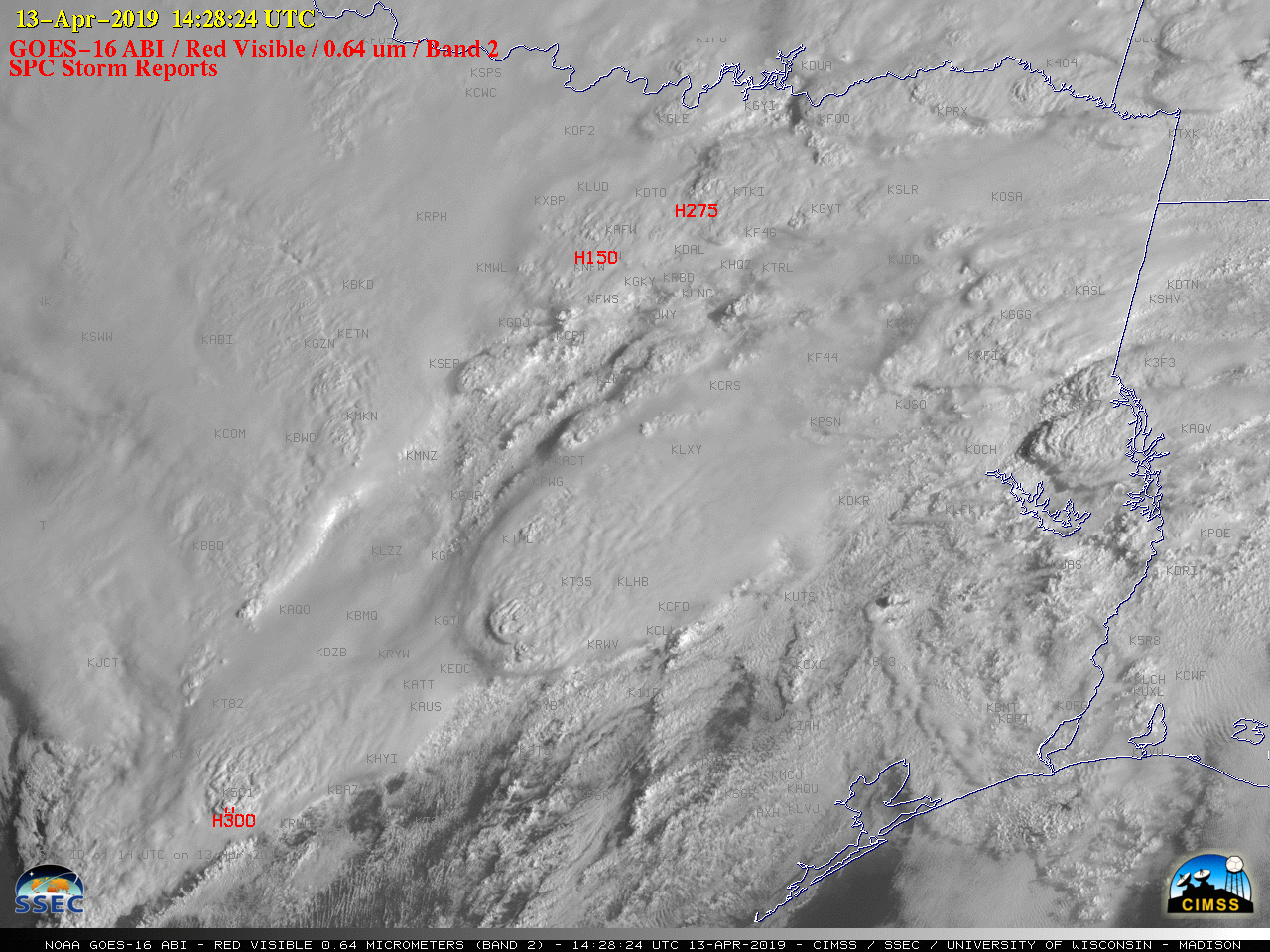
GOES-16 “Red” Visible (0.64 µm) images, with SPC storm reports plotted in red [click to play MP4 animation]
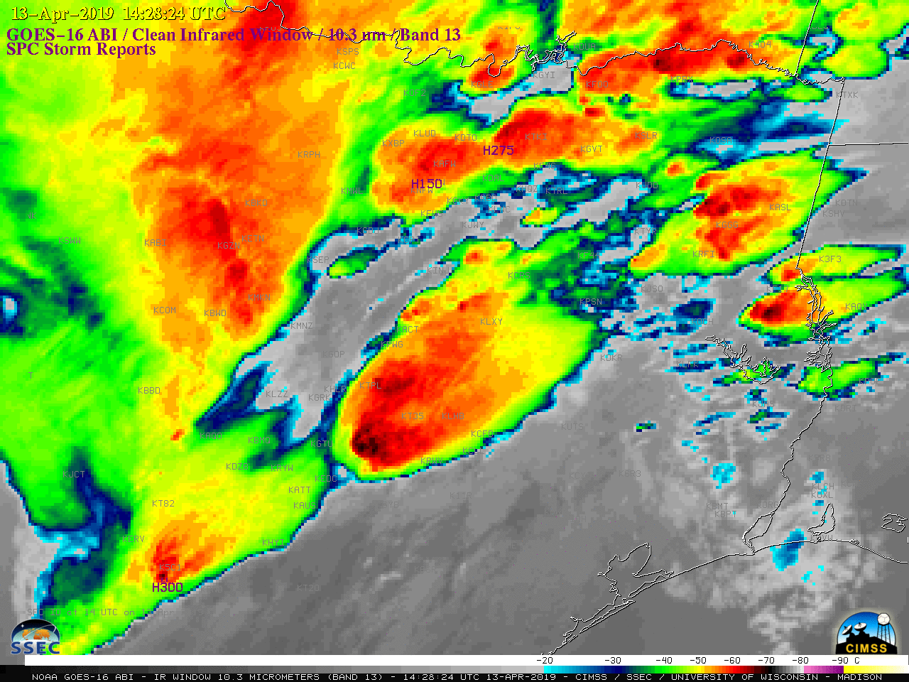
![GOES-16 "Clean" Infrared Window (10.3 µm) images, with SPC storm reports plotted in purple [click to play MP4 animation]](https://cimss.ssec.wisc.edu/satellite-blog/wp-content/uploads/sites/5/2019/04/G16_IR_NOGLM_TX_SVR_13APR2019_2019103_142824_GOES-16_0001PANEL.GIF)
GOES-16 “Clean” Infrared Window (10.3 µm) images, with SPC storm reports plotted in purple [click to play MP4 animation]
![Terra MODIS Visible (0.65 µm) and Infrared Window (11.0 µm) images [click to enlarge]](https://cimss.ssec.wisc.edu/satellite-blog/wp-content/uploads/sites/5/2019/04/190413_1650uc_terra_modis_visible_infrared_spcStormReports_anim.gif)
Terra MODIS Visible (0.65 µm) and Infrared Window (11.0 µm) images [click to enlarge]
![GOES-16 "Red" Visible (0.64 µm) images, with SPC storm reports plotted in red [click to play MP4 animation]](https://cimss.ssec.wisc.edu/satellite-blog/wp-content/uploads/sites/5/2019/04/G16_VIS_NOGLM_TX_LA_MS_SVR_13APR2019_2019103_211525_GOES-16_0001PANEL.GIF)
GOES-16 “Red” Visible (0.64 µm) images, with SPC storm reports plotted in red [click to play MP4 animation]
![GOES-16 "Clean" Infrared Window (10.3 µm) images, with SPC storm reports plotted in cyan [click to play MP4 animation]](https://cimss.ssec.wisc.edu/satellite-blog/wp-content/uploads/sites/5/2019/04/G16_IR_NOGLM_TX_LA_MS_SVR_13APR2019_2019103_211525_GOES-16_0001PANEL.GIF)
GOES-16 “Clean” Infrared Window (10.3 µm) images, with SPC storm reports plotted in cyan [click to play MP4 animation]
![GOES-16 "Clean" Infrared Window (10.3 µm) images, with SPC storm reports plotted in cyan [click to play MP4 animation]](https://cimss.ssec.wisc.edu/satellite-blog/wp-content/uploads/sites/5/2019/04/G16_IR_MS_AL_SVR_13APR2019_2019104_040755_GOES-16_0001PANEL.GIF)
GOES-16 “Clean” Infrared Window (10.3 µm) images, with SPC storm reports plotted in cyan [click to play MP4 animation]
![VIIRS Day/Night Band (0.7 µm) and Infrared Window (11.45 µm) images from Suomi NPP and NOAA-20 [click to enlarge]](https://cimss.ssec.wisc.edu/satellite-blog/wp-content/uploads/sites/5/2019/04/190414_0645utc_0734utc_viirs_dayNightBand_infraredWindow_spcStormReports_anim.gif)
VIIRS Day/Night Band (0.7 µm) and Infrared Window (11.45 µm) images from NOAA-20 at 0645 UTC and Suomi NPP at 0734 UTC [click to enlarge]
![NOAA-20 VIIRS Day/Night Band (0.7 µm) image at 0825 UTC [click to enlarge]](https://cimss.ssec.wisc.edu/satellite-blog/wp-content/uploads/sites/5/2019/04/al_viirs_dnb_post_saturation_recovery-20190414_082514.png)
NOAA-20 VIIRS Day/Night Band (0.7 µm) image at 0825 UTC [click to enlarge]