
GOES-16 “Red” Visible (0.64 µm, top) and Near-Infrared “Snow/Ice” (1.61 µm, bottom) images, with plots of hourly surface reports [click to play MP4 animation]
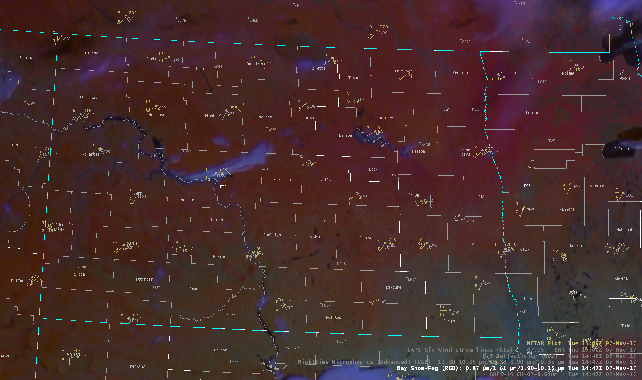
* GOES-16 data posted on this page are preliminary, non-operational and are undergoing testing *
As cold arctic air continued to move eastward across North Dakota on 07 November 2017, GOES-16 “Red” Visible (0.64 µm) and Near-Infrared “Snow/Ice” (1.61 µm) images (above) showed “lake effect” cloud plumes streaming east-northeastward from Lake Sakakawea (and also from Missouri River). The Snow/Ice images were the most useful for discriminating between supercooled water droplet cloud plumes (brighter shades of white) and the surrounding snow-covered land surfaces (darker shades of gray).
During the preceding nighttime hours, Suomi NPP VIIRS and Aqua MODIS Infrared Brightness Temperature Difference images (below) — the legacy “fog/stratus product” — revealed that the orientation of the Lake Sakakawea cloud plume changed as surface winds switched from northwesterly to westerly.
![Infrared Brightness Temperature Difference images from Suomi NPP VIIRS (11.45 µm = 3.74 µm) and Aqua MODIS (11.0 µm - 3.7 µm) [click to enlarge]](http://cimss.ssec.wisc.edu/satellite-blog/wp-content/uploads/2017/11/171107_viirs_modis_ir_btd_ND_anim.gif)
Infrared Brightness Temperature Difference images from Suomi NPP VIIRS (11.45 µm = 3.74 µm) and Aqua MODIS (11.0 µm – 3.7 µm) [click to enlarge]
The Aqua MODIS Sea Surface Temperature product
(below) indicated that the water in Lake Sakakawea was as warm as 47.9ºF
(darker green enhancement) — significantly warmer than the surface air passing over it, which was generally in the 5 to 15ºF range.
![Aqua MODIS Sea Surface Temperature product [click to enlarge]](http://cimss.ssec.wisc.edu/satellite-blog/wp-content/uploads/2017/11/MODIS_SST_20171107_1930.png)
Aqua MODIS Sea Surface Temperature product [click to enlarge]
The large cloud plume from Lake Sakakawea was also very evident on GOES-16 Day Snow-Fog Red-Green-Blue (RGB) images
(below). Farther to the east, smaller and shorter-lived cloud plumes could also be seen originating from Devils Lake
(along the Benson/Ramsey county line) and Stump Lake
(in Nelson county).
![GOES-16 Day Snow-Fog RGB images [click to animate]](http://cimss.ssec.wisc.edu/satellite-blog/wp-content/uploads/2017/11/20171107_G16DaySnowFogMTR-15.png)
GOES-16 Day Snow-Fog RGB images [click to animate]
Taking a closer look at the Lake Sakakawea area, the brighter signature of steam plumes rising from power plants located south and southeast of the lake (2 in Mercer county, and 1 in McLean county) could be spotted on the Day Snow-Fog RGB images
(below).
![GOES-16 Day Snow-Fog RGB images [click to animate]](http://cimss.ssec.wisc.edu/satellite-blog/wp-content/uploads/2017/11/20171107_G16DaySnowFogPowerPlantPlumeZoom-10.png)
GOES-16 Day Snow-Fog RGB images [click to animate]
Due to the low sun angle and the snow-covered land surface, morning shadows from these rising steam plumes could be seen on GOES-16 “Red” Visible (0.64 µm) images
(below).

GOES-16 “Red” Visible images [click to animate]
Special thanks to Carl Jones (NWS Grand Forks) for bringing this case to our attention, and supplying the AWIPS RGB and Visible images at the bottom of the blog post.