This website works best with a newer web browser such as Chrome, Firefox, Safari or Microsoft Edge. Internet Explorer is not supported by this website.

Category: Terra

Hurricane Florence continues to approach the southeastern US

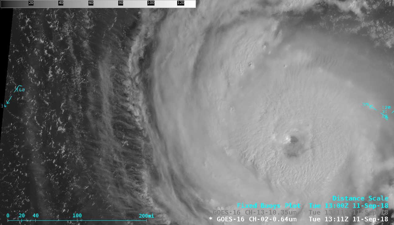
Hurricane Florence maintained Category 4 intensity on the morning of 11 September 2018 — and 1-minute (initially 30-second, until 1345 UTC) Mesoscale Domain Sector GOES-16 (GOES-East) “Red” Visible (0.64 µm) images (above) and “Clean” Infrared Window (10.3 µm) images (below) showed improving eye structure after the tropical cyclone completed an eyewall replacement cycle during the... Read More

Severe thunderstorms in Wisconsin

Thunderstorms produced a variety of severe weather (SPC storm reports) as they moved eastward across the Upper Midwest on 28 August 2018. 1-minute Mesoscale Domain Sector GOES-16 (GOES-East) “Red” Visible (0.64 µm) images (above) and “Clean” Infrared Window (10.3 µm) images (below) showed the development and progression of the severe convection across central Wisconsin.Toggles beween Visible and Infrared... Read More

Wildfires in British Columbia

A 2-panel comparison of GOES-16 (GOES-East) “Red” Visible (0.64 µm) and Shortwave Infrared (3.9 µm) images (above) showed the smoke plumes and thermal anomalies or “hot spots” (darker black to red pixels) associated with a flare-up of wildfires in western British Columbia on 17 August 2018.A sequence of Shortwave Infrared (3.7 µm) images from... Read More

Large hail and high winds in South Dakota and Nebraska

A supercell thunderstorm which developed in southeastern Montana during the afternoon hours on 27 July 2018 produced damaging wind-driven hail as it moved southeastward across western South Dakota into far northern Nebraska (SPC storm reports | NWS Rapid City summary). 1-minute Mesoscale Domain Sector GOES-16 (GOES-East) “Red” Visible (0.64 µm) images (above) showed the evolution of this storm.The corresponding GOES-16... Read More