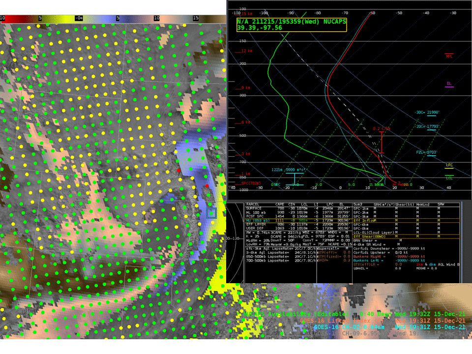
This website works best with a newer web browser such as Chrome, Firefox, Safari or Microsoft Edge. Internet Explorer is not supported by this website.

Category: Severe convection

Severe thunderstorms in northern Minnesota

1–minute Mesoscale Domain Sector GOES-16 (GOES-East) “Red” Visible (0.64 µm) images and “Clean” Infrared Window (10.35 µm) images (above) include time-matched plots of SPC Storm Reports produced by supercell thunderstorms that moved east-southeastward across northern Minnesota during the afternoon and early evening hours on 26 July 2021. Severe reports included a tornado at 2213 UTC and hail as large as to 3.0 inches in diameter... Read More

Severe weather in the central Plains

1-minute Mesoscale Domain Sector GOES-16 (GOES-East) “Red” Visible (0.64 µm) images (above) include time-matched plots of SPC Storm Reports — and showed severe thunderstorms across eastern Colorado, western Kansas and far southwestern Nebraska late in the day on 19 June 2021. Numerous pulsing overshooting tops were evident with many of these storms. Wind gusts to 88 mph were reported in KansasThe corresponding 1-minute GOES-16... Read More

Severe weather associated with the landfall of Tropical Storm Claudette

1-minute Mesoscale Domain Sector GOES-16 (GOES-East) “Red” Visible (0.64 µm) images (above) include time-matched plots of SPC Storm Reports — and showed severe thunderstorms associated with the landfall of Tropical Storm Claudette (surface analyses) early in the day on 19 June 2021. Numerous pulsing overshooting tops were evident with some of these storms.The corresponding 1-minute GOES-16 “Clean” Infrared Window (10.35 µm) images (below) displayed cloud-top infrared brightness temperatures as cold... Read More