Hurricane Ophelia over the central Atlantic
Hurricane Ophelia, the fourth hurricane of the north Atlantic tropical season, is pictured above near peak intensity as it moves over the open waters of the Atlantic Ocean, northeast of Hispaniola (which island is visible in the southwest corner of the image loop). The hurricane displays a circular central dense overcast region around a eye in which one might infer the presence of small-scale vortices. Several factors argue for weakening with Ophelia. Note in the animation the motion of the cirrus clouds entering the frame from the west. These high-level winds suggest an increase the shear over Ophelia, and in fact the convective distribution around the storm shows an asymmetry with more convection east of the center. Further, Ophelia’s projected track takes it across a region of ocean that is cooler following the passage of major Hurricane Katia earlier in September. This cool wake limits the energy available to subsequent storms like Ophelia. This loop toggles between images retrieved from the CIMSS Tropical Weather website, showing an enhanced infrared image and a mapping of the sea surface temperatures over the Atlantic in which the wake of Katia is plain. Observations from AVHRR confirm the existence of the cooler SSTs ahead of Ophelia.
The vigor of the convection within a hurricane can be measured by the number of overshooting tops within the circulation. This plot, for example, shows a weakening in Katia as the number of overshooting tops dropped on 2 September. Overshooting tops can be inferred by differencing the 10.7 µm and 6.5 µm channels on the GOES imager. This animation shows only occasional evidence of overshooting tops. Visible imagery from GOES-15 shows evidence of a few overshoots possibly north of the center, and in a spiral band east of the center. A very oblique view from GOES-11 suggests a similar distribution to the overshoots, but also shows a mostly smooth cirrus canopy above the hurricane. The number of overshoots should decrease as Ophelia moves over the cooler waters to its north.
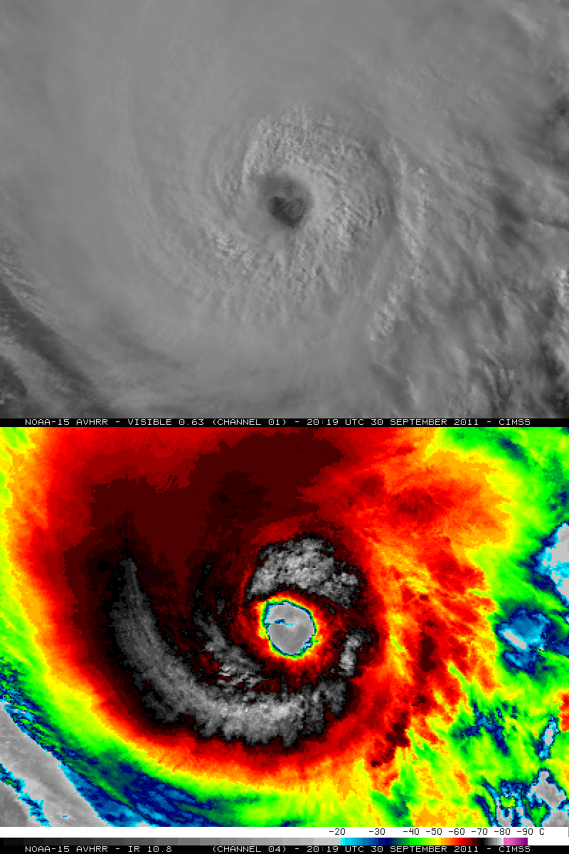
Added: This POES AVHRR Infrared image, showing half of the storm, shows cloud tops as cold as -77 C, but little in the way of overshooting tops. A comparison of this same POES AVHRR IR image (viewed using McIDAS)Â with the corresponding POES AVHRR visible image (below) nicely shows the curved convective band that was wrapping around they eye of Hurricane Ophelia.


