Invest 94W Poised to Become Tropical Cyclone
A deepening circulation north of Palau in the western Pacific is projected to intensify into a tropical storm between 3 and 4 February 2026. This system is currently (as of 1600 UTC on 3 Feb 2026) labeled as Invest 94W, but analysis from the Joint Typhoon Warning Center projects intensification into a tropical cyclone. A closer look at satellite products can help inform the discussion of what will happen next. Infrared satellite imagery from Himawari-9’s Advanced Himawai Imager reveals a largely asymmetric circulation between Palau and the Micronesian island of Yap.

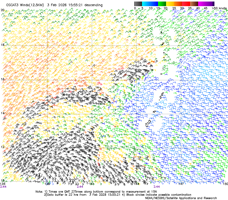
It can be hard to identify the center of circulation given upper level divergent flow is at times obscuring the lower level flow. Scatterometry can help clear up the confusion by providing a more easily-discernible view of the ocean surface-level winds. Unfortunately, the center of circulation has slipped through the gaps of the most recent ASCAT overpasses, so the broader but noisier OSCAT-3 winds have to be used instead. Winds appear to be on the order of 30-40 kts at the heart of the circulation.
Of course, warm sea surface temperatures are an important factor in tropical cyclone development. The NOAA Geo-Polar blended SST product is a valuable resource for this. Here, the area surrounding the invest has been circled to aid in location. SSTs are between 28-32 C (82 -90 F) so a substantial amount of latent heat is available for the developing system to access.

Larges amounts of water vapor are present in the atmosphere as well, as seen in the CIMSS MIMIC-TPW2 product. The invest is found between 130 and40 degrees E at 10 degrees N. These satellite-derived total precipitable water values are approaching 70 mm.

The CIMSS Environmental Steering product calculates mean winds over various layers through analysis of satellite-observed motion. For an as-yet weaker system like Invest 94W, the 700-850 hPa mean layer can provide useful insight (stronger cyclones use deeper layers). Here, the steering flow suggests that the system will propagate westward toward the Philippines as time progresses.
