Super Typhoon Ragasa (Nando) hits Philippines, Taiwan
For the past few days, the eyes of the Philippines and Taiwan have been focused on a developing tropical system in the western Pacific. What began as a small group of convective cells northwest of Micronesia on 16 September 2025 has grown into the most intense tropical system up to this point in 2025. Super Typhoon Ragasa (called Nando in the Philippines as the Philippine national meteorological service maintains a separate list of typhoon names). A super typhoon is broadly equivalent to a strong category 4 hurricane on the Saffir-Simpson scale. For a storm to achieve super typhoon status, winds have to be in excess of 130 kts (the upper bound for a category 4 storm is 136 kts).
The rapid intensification of Ragasa can be seen in the Advanced Himawari Imager (AHI) view over the last three days starting at 0300 UTC in 19 September 2025. Using the Band 13 infrared view enables the consistent monitoring of the storm at all hours of the day.
We’ll discuss a few key moments from this loop. At the start of the animation (0300 UTC on 19 September), the system had just been classified as a tropical storm only a few hours earlier. Overall organization is weak and no eye is present.

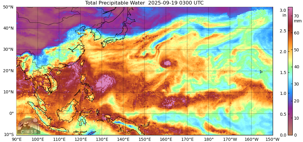
However, this area was well-suited for tropical intensification. First, note the CIMSS MIMIC-2 total precipitable water (TPW) imagery from the same time as the above IR satellite view. TPW values are elevated in the western Pacific. Even outside of the storm itself (seen as the fuchsia area exceeding the top of the color scale), MIMIC indicates TPW of more than 60 mm west of the Philippines.
Second, the sea surface temperatures (SSTs)in this area were quite warm. The NCEP SST product, as mapped by SSEC, shows temperatures approaching 32 C (90 F).
In fact, these temperatures are 1-2 C above normal, as determined by the NOAA Coral Reef Watch daily SST anomaly plot, seen here for 19 September.

With lots of atmospheric moisture and significant amounts of warm oceanic water, the latent heat machine that drives tropical systems sprang into life, and the newly christened Ragasa quickly intensified. By 2100 UTC on the 19th, an eyelike structure could be seen at the center of rotation.

Over the next day, the eye structure strengthened and then went through an eyewall replacement cycle but retained its strength at teh conclusion of that process. Evacuations were ordered for parts of the Philippines and Taiwan in anticipation of landfall. Sustained winds in excess of 115 kts were reported at 0000UTC on the 21st as the storm exhibited a compact eye.

By 0000 UTC on the 22nd, those sustained winds had increased to 145 kts putting the storm solidly into Category 5 status. The large eye of Ragasa is passing north of the large Philippine island of Luzon, though that region will be battered by significant winds over the coming day. This can be seen in the 10 min Himawari target imagery, which is following Ragasa as it progresses westward.
At this point Ragasa is projected to continue west-northwest and pass very close to Hong Kong. The past and projected track can be seen on the forecast graphic product from the Joint Typhoon Warning Center, issued at 0000 UTC on 22 September.

Additional information pertaining to Ragasa is available in this blog post.