Midwest Derecho
![GOES-16 “Red” Visible (0.64 µm) images, with SPC Storm Reports plotted in red [click to play animation | MP4]](https://cimss.ssec.wisc.edu/satellite-blog/images/2020/08/200810_goes16_visible_spcStormReports_Midwest_Derecho_anim.gif)
GOES-16 “Red” Visible (0.64 µm) images, with SPC Storm Reports plotted in red [click to play animation | MP4]
The corresponding GOES-16 “Clean” Infrared Window (10.35 µm) images are shown below.
![GOES-16 “Clean” Infrared Window (10.35 µm) images, with SPC Storm Reports plotted in cyan [click to play animation | MP4]](https://cimss.ssec.wisc.edu/satellite-blog/images/2020/08/200810_goes16_infrared_spcStormReports_Midwest_Derecho_anim.gif)
GOES-16 “Clean” Infrared Window (10.35 µm) images, with SPC Storm Reports plotted in cyan [click to play animation | MP4]
![Comparison of Infrared Window images from Suomi NPP (11.45 µm) and GOES-16 (10.35 µm) at 1931 UTC [click to enlarge]](https://cimss.ssec.wisc.edu/satellite-blog/images/2020/08/200810_1931utc_suomiNPP_goes16_infrared_WI_IL_anim.gif)
Comparison of Infrared Window images from Suomi NPP (11.45 µm) and GOES-16 (10.35 µm) at 1931 UTC [click to enlarge]
![GOES-16 Visible/Infrared Sandwich RGB and “Clean” Infrared Window (10.35 µm) images, with “probability of intense convection” contours and SPC Storm Reports (credit: John Cintineo, CIMSS) [click to play animation | MP4]](https://cimss.ssec.wisc.edu/satellite-blog/images/2020/08/derecho_20200810.GIF)
GOES-16 Visible/Infrared Sandwich RGB and “Clean” Infrared Window (10.35 µm) images, with “probability of intense convection” contours and SPC Storm Reports (credit: John Cintineo, CIMSS) [click to play animation | MP4]
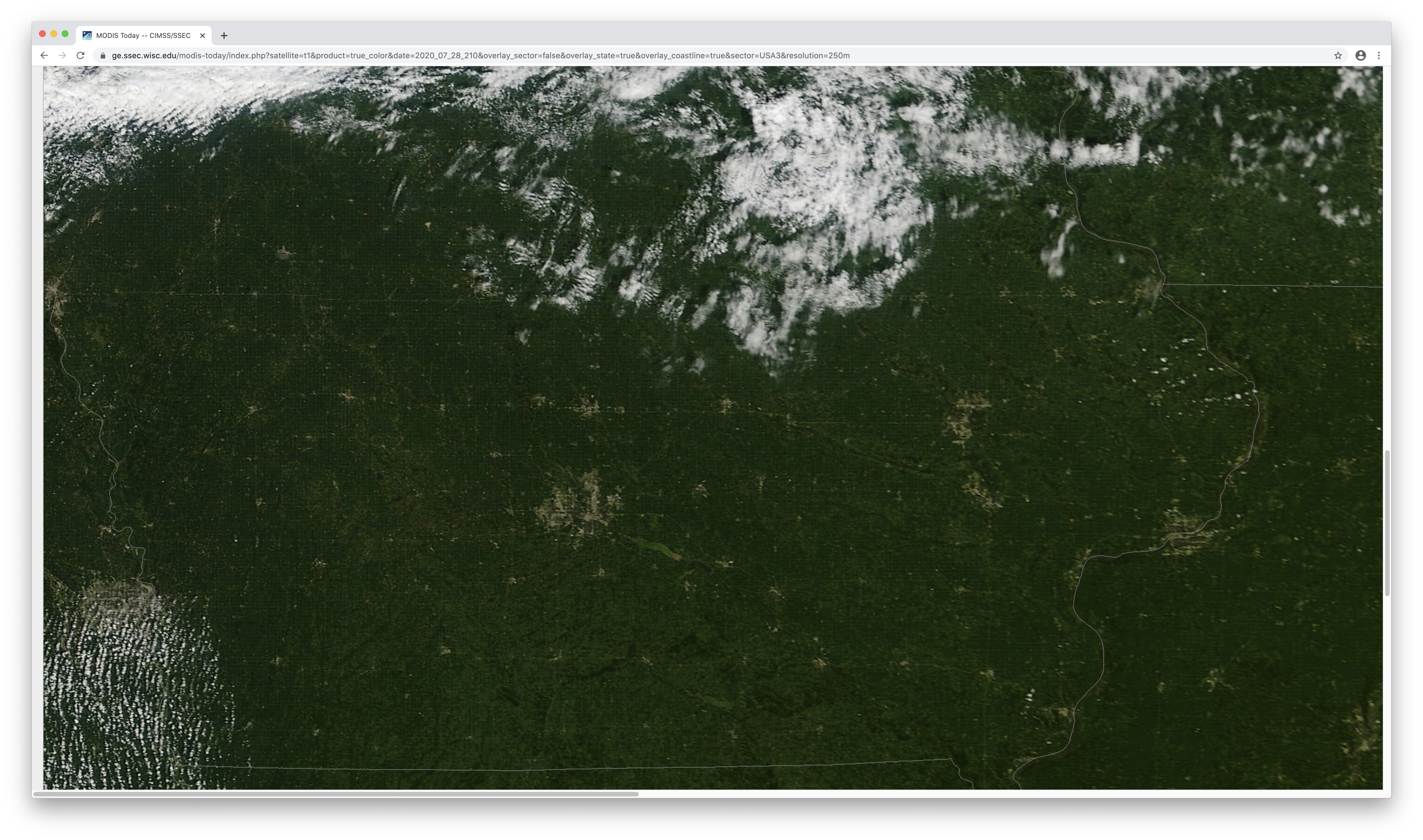
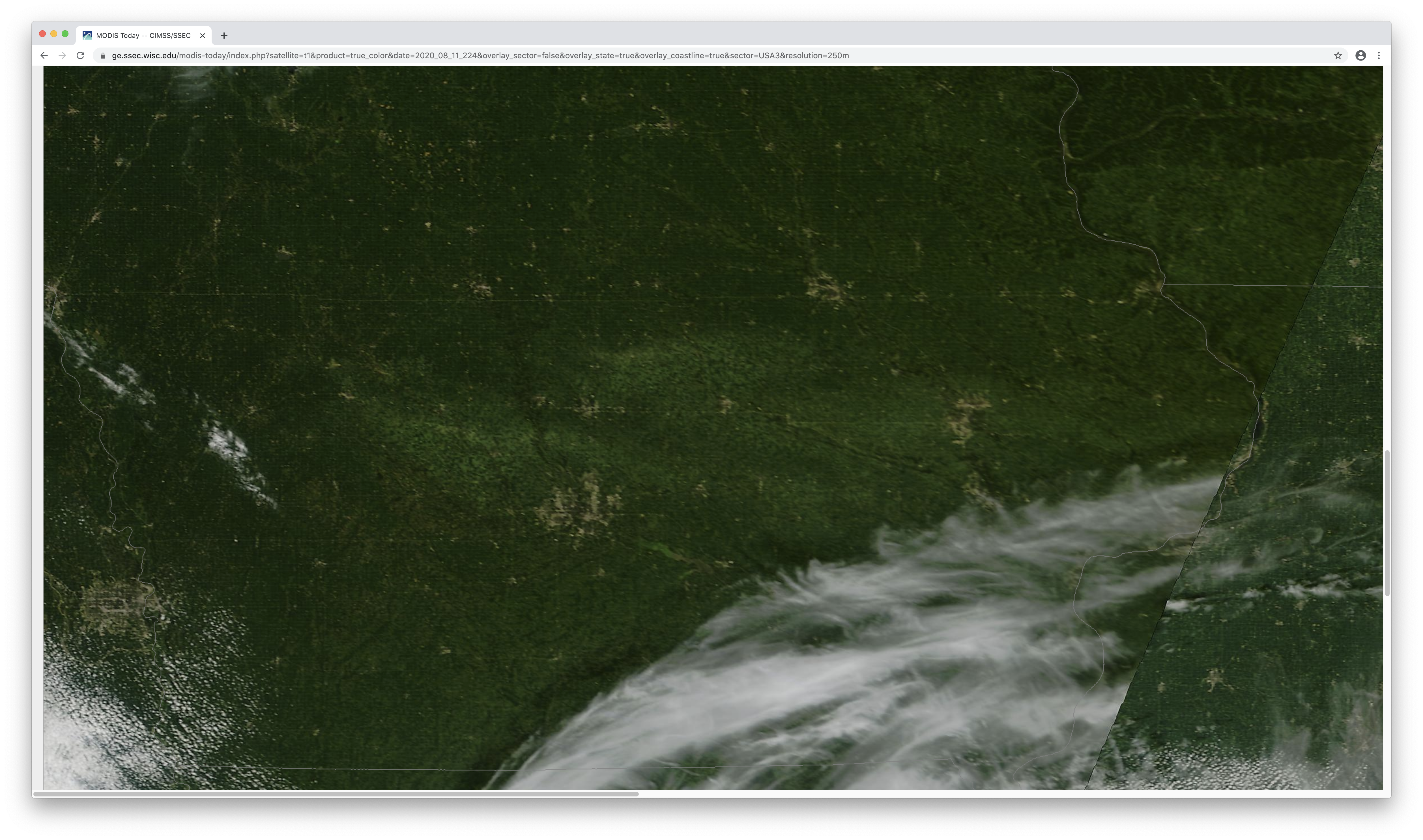
![Comparison of before (28 July) / after (11 August) Terra MODIS True Color RGB images centered over Iowa [click to enlarge]](https://cimss.ssec.wisc.edu/satellite-blog/images/2020/08/200728_200811_terra_modis_trueColorRGB_Iowa_derecho_crop_damage_anim.gif)
Comparison of before (28 July) / after (11 August) Terra MODIS True Color RGB images centered over Iowa [click to enlarge]
![VIIRS True Color RGB images from Suomi NPP and NOAA-20 -- with and without map labels [click to enlarge]](https://cimss.ssec.wisc.edu/satellite-blog/images/2020/08/200811_suomiNPP_noaa20_viirs_trueColorRGB_IA_anim.gif)
VIIRS True Color RGB images from Suomi NPP and NOAA-20 — with and without map labels [click to enlarge]
![VIIRS Day/Night Band (0.7 µm) images on 28 July and 11 August, along with a MODIS True Color RGB image on 11 August [click to enlarge]](https://cimss.ssec.wisc.edu/satellite-blog/images/2020/08/200728_200811_viirs_dayNightBand_modis_trueColorRGB_IA_anim.gif)
VIIRS Day/Night Band (0.7 µm) images on 28 July and 11 August, along with a MODIS True Color RGB image on 11 August [click to enlarge]
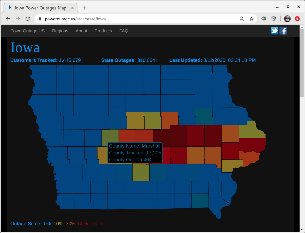
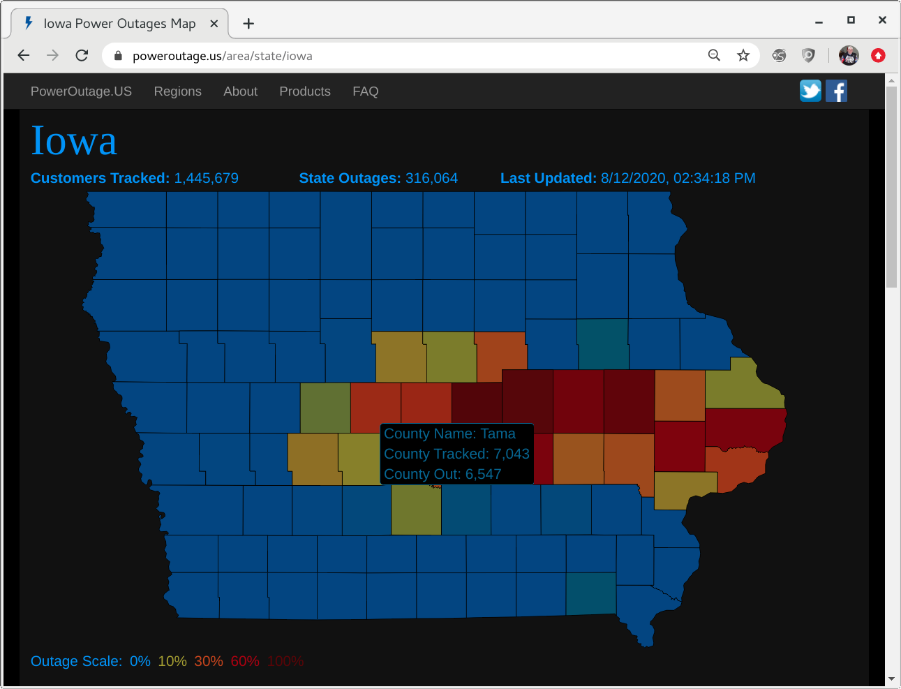
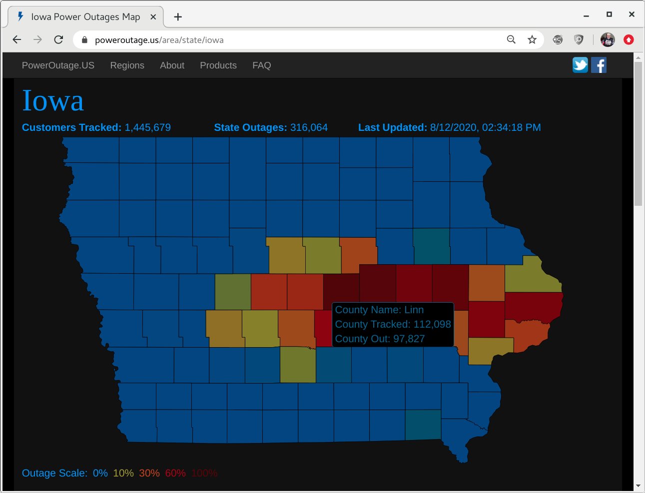
![Iowa counties with power outages on 12 August [click to enlarge]](https://cimss.ssec.wisc.edu/satellite-blog/images/2020/08/200812_IA_power_outages.png)
Iowa counties with power outages on 12 August [click to enlarge]
Updated estimated wind speed map for the #derecho2020. #iawx #IowaDerecho pic.twitter.com/XMaAgc6oHT
— NWS Des Moines (@NWSDesMoines) August 20, 2020