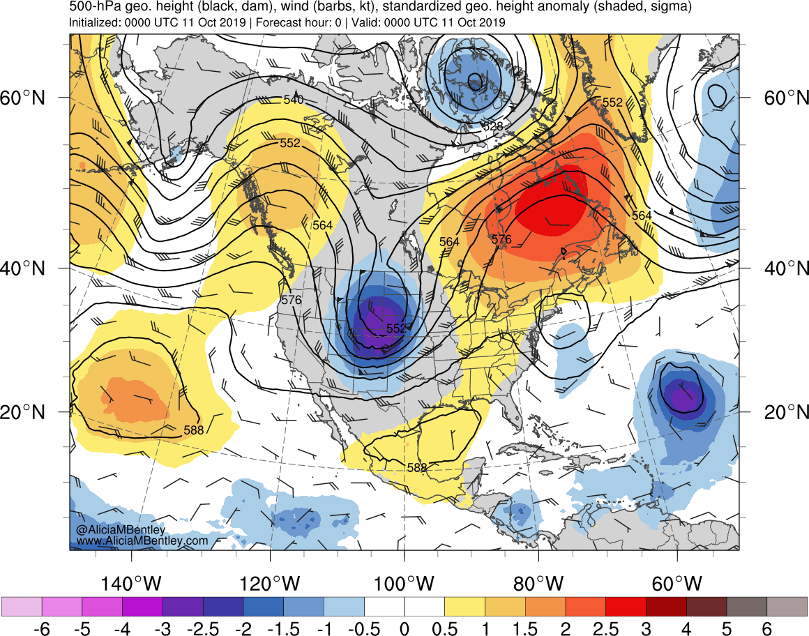
Early-season winter storm in the Northern Plains
![GOES-16 Mid-level Water Vapor (6.9 µm) images, with hourly surface weather type plotted in red [click to play animation | MP4]](https://cimss.ssec.wisc.edu/satellite-blog/wp-content/uploads/sites/5/2019/10/191009_191012_goes16_waterVapor_surfaceWeatherType_anim.gif)
GOES-16 Mid-level Water Vapor (6.9 µm) images, with hourly surface weather type plotted in red [click to play animation | MP4]
GOES-16 “Red” Visible (0.64 µm) images (below) displayed the storm during the daylight hours on 10/11/12 October.
![GOES-16 "Red" Visible (0.64 µm) images on 10/11/12 October, with hourly precipitation type plotted in red [click to play animation | MP4]](https://cimss.ssec.wisc.edu/satellite-blog/wp-content/uploads/sites/5/2019/10/191010_191012_goes16_visible_surfaceWeatherType_anim.gif)
GOES-16 “Red” Visible (0.64 µm) images on 10/11/12 October, with hourly precipitation type plotted in red [click to play animation | MP4]

GOES-16 “Red” Visible (0.64 µm) images, with an overlay of GLM Flash Extent Density [click to play animation | MP4]
![GOES-16 "Red" Visible (0.64 µm, left) and Mid-level Water Vapor (6.9 µm, right) images, with GLM Groups plotted in red [click to play animation | MP4]](https://cimss.ssec.wisc.edu/satellite-blog/wp-content/uploads/sites/5/2019/10/191011_goes16_visible_waterVapor_glm_ND_MN_MB_anim.gif)
GOES-16 “Red” Visible (0.64 µm, left) and Mid-level Water Vapor (6.9 µm, right) images, with GLM Groups plotted in red [click to play animation | MP4]
![GOES-16 Mid-level Water Vapor (6.9 µm) images, with 295 K equivalent potential temperature contours plotted in yellow and surface fronts plotted in red [click to play animation | MP4]](https://cimss.ssec.wisc.edu/satellite-blog/wp-content/uploads/sites/5/2019/10/191011_goes16_waterVapor_thetaE_Upper_Midwest_trowal_anim.gif)
GOES-16 Mid-level Water Vapor (6.9 µm) images, with 295 K Equivalent Potential Temperature contours plotted in yellow and surface fronts plotted in red [click to play animation | MP4]
![GOES-16 Mid-level Water Vapor (6.9 µm) images, with 295 K Specific Humidity contours plotted in yellow and surface fronts plotted in red [click to play animation | MP4]](https://cimss.ssec.wisc.edu/satellite-blog/wp-content/uploads/sites/5/2019/10/191011_goes16_waterVapor_295K_specificHumidity_Upper_Midwest_trowal_anim.gif)
GOES-16 Mid-level Water Vapor (6.9 µm) images, with 295 K Specific Humidity contours plotted in yellow and surface fronts plotted in red [click to play animation | MP4]
![Cross section of RAP40 model fields along Line B-B' at 16 UTC [click to enlarge]](https://cimss.ssec.wisc.edu/satellite-blog/wp-content/uploads/sites/5/2019/10/191011_16utc_LineB_cros_section_anim.gif)
Cross section of RAP40 model fields along Line B-B’ at 16 UTC [click to enlarge]
![GOES-16 Mid-level Water Vapor (6.9 µm) images, with surface frontal positions [click to play animation]](https://cimss.ssec.wisc.edu/satellite-blog/wp-content/uploads/sites/5/2019/10/191012_goes16_waterVapor_fronts_anim.gif)
GOES-16 Mid-level Water Vapor (6.9 µm) images, with surface frontal positions [click to play animation | MP4]
Here are your 3 day storm total snowfall reports across central ND. #NDWX pic.twitter.com/UA5JvAAgd0
— NWS Bismarck (@NWSBismarck) October 12, 2019
Event Review for Oct 10-12th. Preliminary, still in progress. https://t.co/473C9RB6Qr pic.twitter.com/HT5t374Tzl
— NWS Grand Forks (@NWSGrandForks) October 13, 2019
===== 17 October Update =====
![Aqua MODIS True Color and False Color RGB images [click to enlarge]](https://cimss.ssec.wisc.edu/satellite-blog/wp-content/uploads/sites/5/2019/10/191017_aqua_modis_truecolor_falsecolor_ND_MN_anim.gif)
Aqua MODIS True Color and False Color RGB images [click to enlarge]
A Suomi NPP VIIRS Flood Product depicting floodwater fractions in the Red River Valley north of Grand Forks ND (as visualized using RealEarth) is shown below.
![Suomi NPP VIIRS Flood Product, depicting floodwater fractions in the Red River Valley north of Grand Forks, ND [click to enlarge]](https://cimss.ssec.wisc.edu/satellite-blog/wp-content/uploads/sites/5/2019/10/191018_river_flood_ND_MN.png)
Suomi NPP VIIRS Flood Product, depicting floodwater fractions in the Red River Valley north of Grand Forks, ND [click to enlarge]
===== 18 October Update =====
![GOES-16 Day Cloud Phase Distinction RGB images [click to play animation | MP4]](https://cimss.ssec.wisc.edu/satellite-blog/wp-content/uploads/sites/5/2019/10/191018_goes16_dayCloudPhaseDistinctionRGB_ND_MB_anim.gif)
GOES-16 Day Cloud Phase Distinction RGB images [click to play animation | MP4]