Hurricane Dorian off the coasts of South Carolina and North Carolina
![GOES-16 “Red” Visible (0.64 µm) and “Clean” Infrared Window (10.35 µm) images [click to play animation | MP4]](https://cimss.ssec.wisc.edu/satellite-blog/wp-content/uploads/sites/5/2019/09/190905_goes16_visible_infrared_Dorian_anim.gif)
GOES-16 “Red” Visible (0.64 µm) and “Clean” Infrared Window (10.35 µm) images [click to play animation | MP4]
![GOES-16 “Clean” Infrared Window (10.35 µm) images, with contours of deep-layer wind shear at 19 UTC [click to enlarge]](https://cimss.ssec.wisc.edu/satellite-blog/wp-content/uploads/sites/5/2019/09/190905_goes16_infrared_19utc_deepLayerWindShear_anim.gif)
GOES-16 “Clean” Infrared Window (10.35 µm) images, with an overlay of deep-layer wind shear at 19 UTC [click to enlarge]
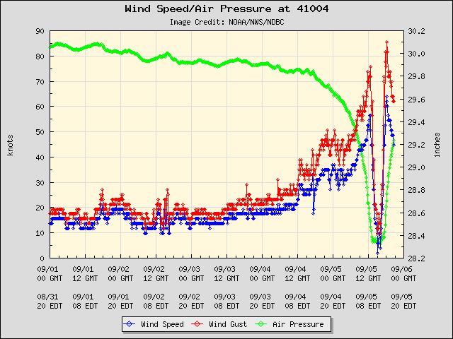
Plot of wind speed (blue), wind gust (red) and air pressure (green) for Buoy 41004
A sequence of VIIRS True Color Red-Green-Blue (RGB) and Infrared Window (11.45 µm) images from Suomi NPP and NOAA-20 as viewed using RealEarth are shown below.
![VIIRS True Color RGB and Infrared Window (11.45 µm) images from Suomi NPP and NOAA-20 [click to enlarge]](https://cimss.ssec.wisc.edu/satellite-blog/wp-content/uploads/sites/5/2019/09/190905_suomiNPP_noaa20_viirs_trueColor_infraredWindow_Dorian_anim.gif)
VIIRS True Color RGB and Infrared Window (11.45 µm) images from Suomi NPP and NOAA-20 [click to enlarge]
===== 06 September Update =====
![GOES-16 “Clean” Infrared Window (10.35 µm) images [click to play animation | MP4]](https://cimss.ssec.wisc.edu/satellite-blog/wp-content/uploads/sites/5/2019/09/190906_goes16_infrared_Dorian_anim.gif)
GOES-16 “Clean” Infrared Window (10.35 µm) images [click to play animation | MP4]