Blowing dust in southern Nevada
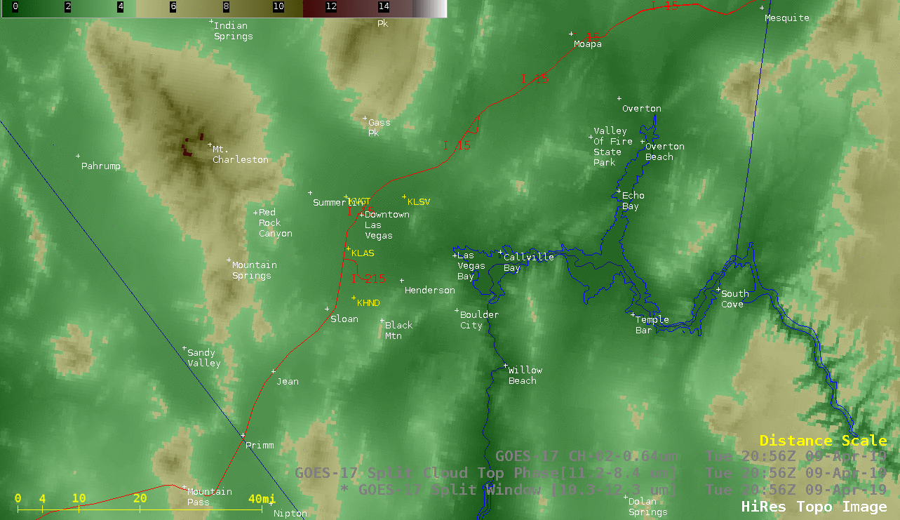
GOES-17 Split Window (10.3-12.3 µm), Split Cloud Top Phase (11.2-8.4 µm) and “Red” Visible (0.64 µm) images [click to play animation | MP4]
This dust plume was also apparent over far southern Nevada in GOES-17 True Color Red-Green-Blue (RGB) images from the AOS site (below).
![GOES-17 True Color RGB images [click to play animation | MP4]](https://cimss.ssec.wisc.edu/satellite-blog/wp-content/uploads/sites/5/2019/04/190409_goes17_truecolor_LAS_blowing_dust_anim.gif)
GOES-17 True Color RGB images [click to play animation | MP4]
![Time series plot of surface data at Henderson [click to enlarge]](https://cimss.ssec.wisc.edu/satellite-blog/wp-content/uploads/sites/5/2019/04/190409_KHND_SFCMG.GIF)
Time series plot of surface data at Henderson [click to enlarge]
![Time series plot of surface data at McCarran International Airport [click to enlarge]](https://cimss.ssec.wisc.edu/satellite-blog/wp-content/uploads/sites/5/2019/04/190409_KLAS_SFCMG.GIF)
Time series plot of surface data at McCarran International Airport [click to enlarge]
![Time series plot of surface data at Nellis Air Force Base [click to enlarge]](https://cimss.ssec.wisc.edu/satellite-blog/wp-content/uploads/sites/5/2019/04/190409_KLSV_SFCMG.GIF)
Time series plot of surface data at Nellis Air Force Base [click to enlarge]
![Time series plot of surface data at Boulder City Municipal Airport [click to enlarge]](https://cimss.ssec.wisc.edu/satellite-blog/wp-content/uploads/sites/5/2019/04/190409_KBVU_SFCMG.GIF)
Time series plot of surface data at Boulder City Municipal Airport [click to enlarge]
![NOAA-19 AVHRR Visible (0.63 µm), Shortwave Infrared (3.8 µm) and Split Window (10.8-12.0 µm) images, with plots of 23 UTC surface reports [click to enlarge]](https://cimss.ssec.wisc.edu/satellite-blog/wp-content/uploads/sites/5/2019/04/190409_2335utc_noaa19_visible_shortwaveInfrared_splitWindowDifference_LAS_blowing_dust_anim.gif)
NOAA-19 AVHRR Visible (0.63 µm), Shortwave Infrared (3.8 µm) and Split Window (10.8-12.0 µm) images, with plots of 23 UTC surface reports [click to enlarge]
Dust plume visible on @nevadadot cam blowing across I-15 near the NV/CA border! Be prepared for reduced visibility! #NVwx #CAwx pic.twitter.com/hkwlgp9IzJ
— NWS Las Vegas (@NWSVegas) April 9, 2019
#VegasWeather – it’s pretty bad out there in some areas. https://t.co/mdzeGNnMSL
— Clark County Nevada (@ClarkCountyNV) April 9, 2019