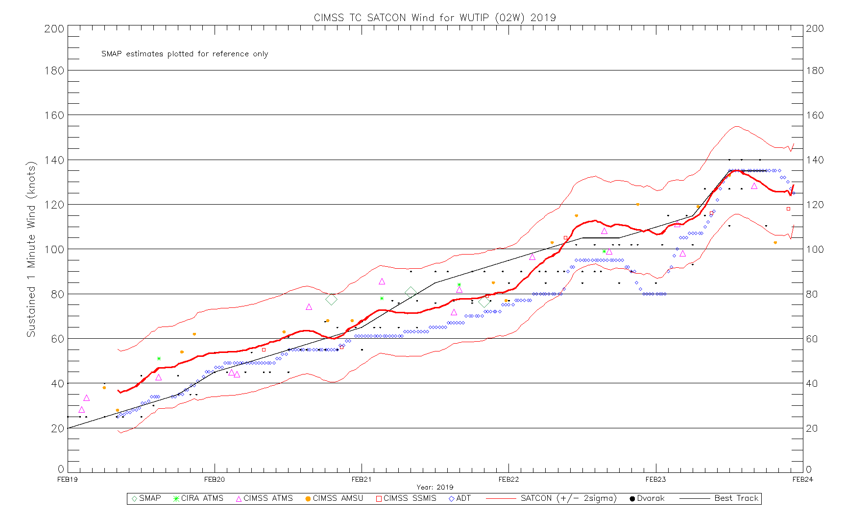
Typhoon Wutip in the West Pacific Ocean
![NOAA-20 VIIRS Day/Night Band (0.7 µm) and Infrared Window (11.45 µm) images at 1502 UTC [click to enlarge]](https://cimss.ssec.wisc.edu/satellite-blog/wp-content/uploads/sites/5/2019/02/190221_1502utc_noaa20_viirs_dayNightBand_infraredWindow_Typhoon_Wutip_anim.gif)
NOAA-20 VIIRS Day/Night Band (0.7 µm) and Infrared Window (11.45 µm) images at 1502 UTC [click to enlarge]
Notable features included deep convection near the storm’s center of circulation (with the presence of subtle cloud-top gravity waves), and transverse banding along the eastern periphery of the cold central dense overcast. Bright pixels seen in the Suomi NPP Day/Night Band image were the result of clouds being illuminated by lightning activity. VIIRS images courtesy of William Straka, CIMSS.
![Suomi NPP VIIRS Day/Night Band (0.7 µm) and Infrared Window (11.45 µm) images at 1552 UTC [click to enlarge]](https://cimss.ssec.wisc.edu/satellite-blog/wp-content/uploads/sites/5/2019/02/190221_1552utc_suomiNPP_viirs_dayNightBand_infraredWindow_Typhoon_Wutip_anim.gif)
Suomi NPP VIIRS Day/Night Band (0.7 µm) and Infrared Window (11.45 µm) images at 1552 UTC [click to enlarge]
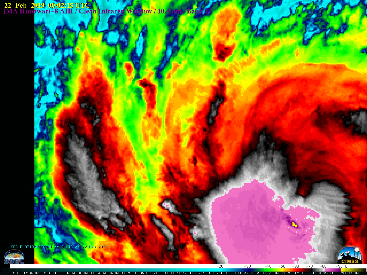
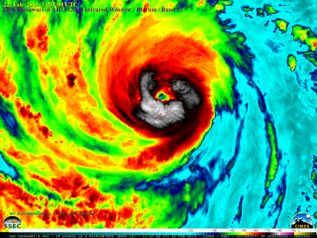
===== 22 February Update =====
![Himawari-8 Infrared Window (10.4 µm) images [click to play MP4 animation]](https://cimss.ssec.wisc.edu/satellite-blog/wp-content/uploads/sites/5/2019/02/HIM08_IR_WUTIP_22FEB2019_2019053_121215_HIMAWARI-8_0001PANEL.GIF)
Himawari-8 Infrared Window (10.4 µm) images [click to play MP4 animation]
Himawari-8 “Red” Visible (0.64 µm) images of Wutip (below) showed that a distinct cloud-free eye did not form during that time period.
![Himawari-8 "Red" Visible (0.64 µm) images [click to play MP4 animation]](https://cimss.ssec.wisc.edu/satellite-blog/wp-content/uploads/sites/5/2019/02/HIM08_VIS_WUTIP_22FEB2019_2019053_034215_HIMAWARI-8_0001PANEL.GIF)
Himawari-8 “Red” Visible (0.64 µm) images [click to play MP4 animation]
![DMSP-17 SSMIS Microwave (85 GHz) image [click to enlarge]](https://cimss.ssec.wisc.edu/satellite-blog/wp-content/uploads/sites/5/2019/02/190222_0916utc_dmsp17_ssmis_microwave_Wutip.png)
DMSP-17 SSMIS Microwave (85 GHz) image [click to enlarge]
![Sea Surface Temperature and Ocean Heat Content [click to enlarge]](https://cimss.ssec.wisc.edu/satellite-blog/wp-content/uploads/sites/5/2019/02/190221_sst_ohc_Wutip_anim.gif)
Sea Surface Temperature and Ocean Heat Content [click to enlarge]
===== 23 February Update =====
![Himawari-8 Infrared Window (10.4 µm) images [click to play MP4 animation]](https://cimss.ssec.wisc.edu/satellite-blog/wp-content/uploads/sites/5/2019/02/HIM08_IR_WUTIP_23FEB2019_2019054_120215_HIMAWARI-8_0001PANEL.GIF)
Himawari-8 Infrared Window (10.4 µm) images [click to play MP4 animation]
In a toggle between NOAA-20 VIIRS Day/Night Band (0.7 µm) and Infrared Window (11.45 µm) images at 1602 UTC (below), these mesovortices were also apparent — with the help of reflected moonlight — in the Day/Night Band.
![NOAA-20 VIIRS Day/Night Band (0.7 µm) and Infrared Window (11.45 µm) images at 1604 UTC [click to enlarge]](https://cimss.ssec.wisc.edu/satellite-blog/wp-content/uploads/sites/5/2019/02/190223_1604utc_noaa20_dayNightBand_infraredWindow_Wutip_anim.gif)
NOAA-20 VIIRS Day/Night Band (0.7 µm) and Infrared Window (11.45 µm) images at 1604 UTC [click to enlarge]
![Himawari-8 Water Vapor (6.9 µm) images with plots of middle/upper-tropospheric derived motion winds [click to enlarge]](https://cimss.ssec.wisc.edu/satellite-blog/wp-content/uploads/sites/5/2019/02/190223_waterVapor_winds_Wutip_anim.gif)
Himawari-8 Water Vapor (6.9 µm) images with plots of middle/upper-tropospheric derived motion winds [click to enlarge]