Rope cloud in the East Pacific Ocean
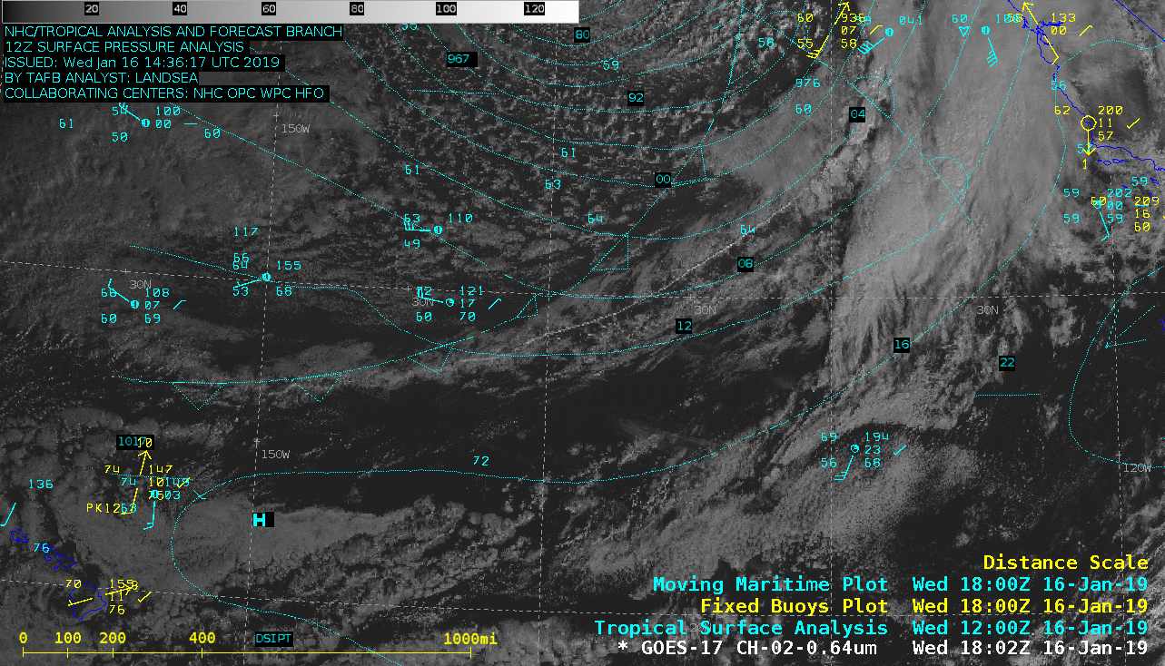
GOES-17 “Red” Visible (0.64 µm) image, with an overlay of the 12 UTC surface analysis [click to enlarge]
* GOES-17 images shown here are preliminary and non-operational *
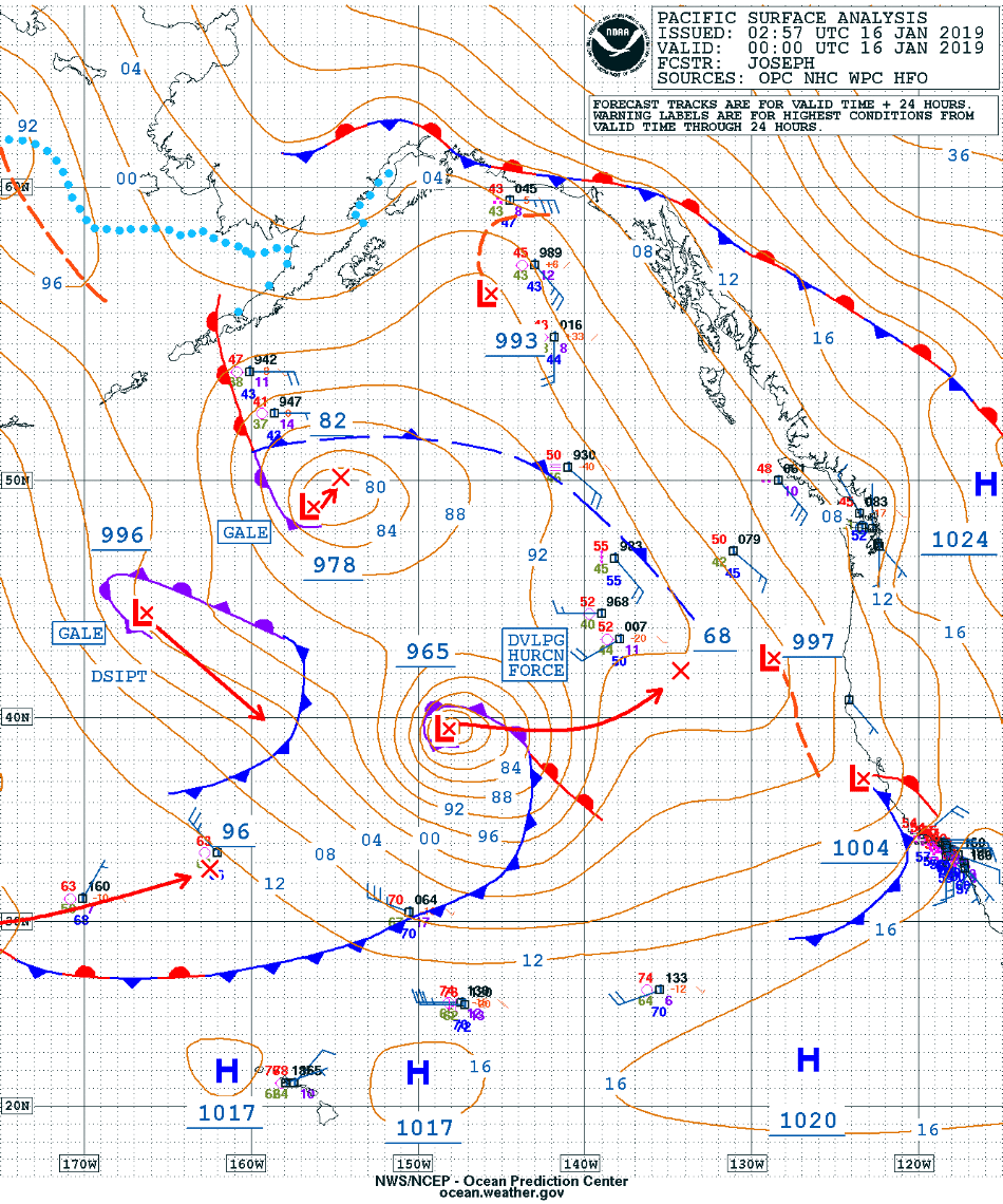
An 1802 UTC GOES-17 “Red” Visible (0.64 µm) image with an overlay of the 12 UTC surface analysis (above) revealed a well-defined rope cloud which stretched for nearly 1000 miles, marking the cold front position at the time of the image. Rope clouds can therefore be used to diagnose the exact location of the leading edge of a cold frontal boundary between times when surface analyses are available. In this case, the cold front was associated with a Hurricane Force low over the East Pacific Ocean on 16 January 2019 (surface analyses).
![GOES-17 "Red" Visible (0.64 µm) images [click to play animation]](https://cimss.ssec.wisc.edu/satellite-blog/wp-content/uploads/sites/5/2019/01/190116_goes17_visible_East_Pacific_rope_cloud_anim.gif)
GOES-17 “Red” Visible (0.64 µm) images [click to play animation]
![GOES-17 "Red" Visible (0.64 µm) images [click to play animation]](https://cimss.ssec.wisc.edu/satellite-blog/wp-content/uploads/sites/5/2019/01/190116_goes17_visible_East_Pacific_rope_cloud_zoom_anim.gif)
GOES-17 “Red” Visible (0.64 µm) images [click to play animation]
![GOES-17 "Red" Visible (0.64 µm) images [click to enlarge]](https://cimss.ssec.wisc.edu/satellite-blog/wp-content/uploads/sites/5/2019/01/rope_zoom2_vis-20190116_194219.png)
GOES-17 “Red” Visible (0.64 µm) images [click to enlarge]
![1802 UTC GOES-17 "Red" Visible (0.64 µm) image, with an overlay of the 18 UTC surface analysis [click to enlarge]](https://cimss.ssec.wisc.edu/satellite-blog/wp-content/uploads/sites/5/2019/01/190116_1802utc_goes17_visible_18utc_surface_analysis_anim.gif)
1802 UTC GOES-17 “Red” Visible (0.64 µm) image, with an overlay of the 18 UTC surface analysis [click to enlarge]
![NOAA-15 AVHRR Visible (0.63 µm) and Infrared Window (10.8 µm) images at 1617 UTC [click to enlarge]](https://cimss.ssec.wisc.edu/satellite-blog/wp-content/uploads/sites/5/2019/01/190116_1617utc_noaa15_visible_infrared_Rope_Cloud_anim.gif)
NOAA-15 AVHRR Visible (0.63 µm) and Infrared Window (10.8 µm) images at 1617 UTC [click to enlarge]
![NOAA-18 AVHRR Visible (0.63 µm) and Infrared Window (10.8 µm) images [click to enlarge]](https://cimss.ssec.wisc.edu/satellite-blog/wp-content/uploads/sites/5/2019/01/190116_1710utc_noaa18_visible_infrared_Rope_Cloud_anim.gif)
NOAA-18 AVHRR Visible (0.63 µm) and Infrared Window (10.8 µm) images at 1710 UTC [click to enlarge]
Check out this “rope cloud” in this morning’s MN2 pass. Pretty defined. UltraTrack with Doppler compensation along with XHRPT. pic.twitter.com/Bc1xtk4hGj
— ??? ???¢?? (@usa_satcom) January 16, 2019
===== 17 January Update =====
![GOES-17 True Color RGB images [click to play animation | MP4]](https://cimss.ssec.wisc.edu/satellite-blog/wp-content/uploads/sites/5/2019/01/190117_goes17_truecolor_HI_anim.gif)
GOES-17 True Color RGB images [click to play animation | MP4]
Surface observations plotted on GOES-17 Visible images (below) showed the wind shift from southwest to north as the cold front moved through Lihue on Kauwa’i around 00 UTC.
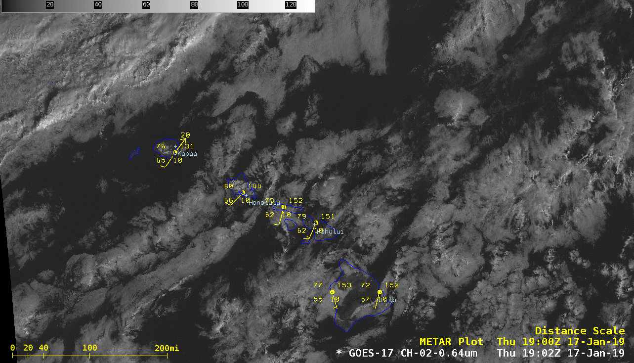
GOES-17 “Red” Visible (0.64 µm) images, with plots of surface reports [click to play animation | MP4]
===== 18 January Update =====
![Suomi NPP VIIRS Day/Night Band (0.7 µm) image, with and without buoy observations [click to enlarge]](https://cimss.ssec.wisc.edu/satellite-blog/wp-content/uploads/sites/5/2019/01/190118_0748utc_suomiNPP_viirs_DayNightBand_Gulf_of_Mexico_rope_cloud_anim.gif)
Suomi NPP VIIRS Day/Night Band (0.7 µm) image, with and without buoy observations [click to enlarge]
A sequence of VIIRS Day/Night Band images from NOAA-20 and Suomi NPP (below) showed the movement of the rope cloud during a time span of about 1.5 hours.
![NOAA-20 and Suomi NPP VIIRS Day/Night Band (0.7 µm) images [click to enlarge]](https://cimss.ssec.wisc.edu/satellite-blog/wp-content/uploads/sites/5/2019/01/190118_noaa20_suomiNPP_viirs_dayNightBand_Gulf_of_Mexico_anim.gif)
NOAA-20 and Suomi NPP VIIRS Day/Night Band (0.7 µm) images [click to enlarge]