Lake effect clouds downwind of Fort Peck Lake, Montana
GOES-17 (left) and GOES-16 (right) “Red” Visible (0.64 µm, top) and Shortwave Infrared (3.9 µm, bottom) images [click to play animation | MP4]
* GOES-17 images shown here are preliminary and non-operational *
A comparison of GOES-17 (soon to become GOES-West) and GOES-16 (GOES-East) “Red” Visible (0.64 µm) and Shortwave Infrared (3.9 µm) images (above) revealed a plume of lake effect clouds streaming south of Fort Peck Lake in northeastern Montana on 11 January 2019. As a cold front moved south-southwestward across the region (surface analyses), surface winds shifted to northerly at Glasgow KGGW which brought a flow of colder air across the still-unfrozen lake. Note that before sunrise the initial formation of the lake effect clouds could be seen on Shortwave Infrared imagery — and after sunrise, the feature appeared progressively warmer (shades of orange) on 3.9 µm images as the supercooled water droplets at the cloud top reflected increasing amounts of incoming solar radiation.
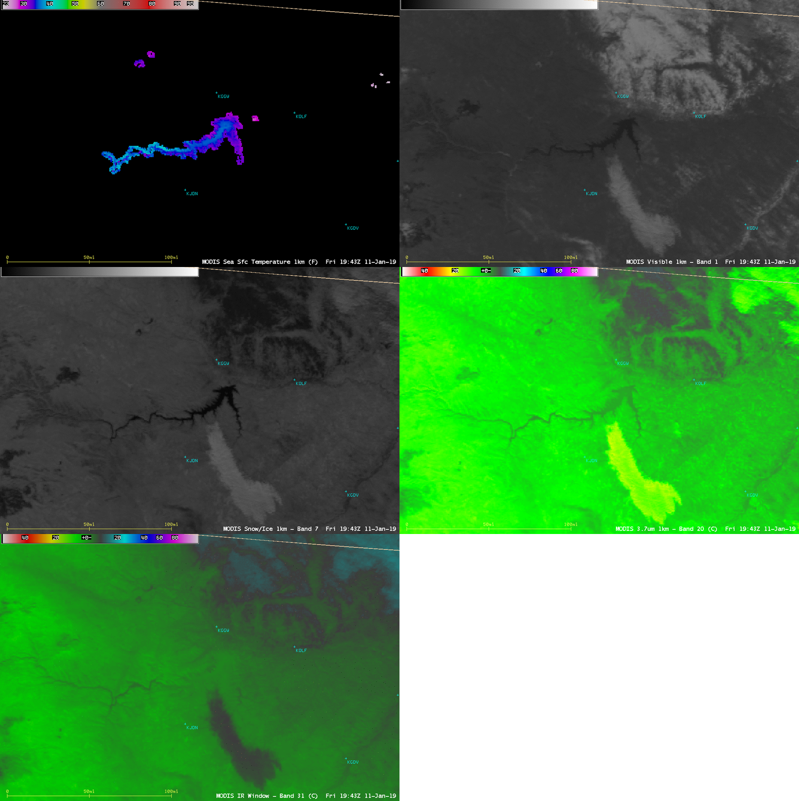
An Aqua MODIS Sea Surface Temperature product at 1942 UTC (below) showed that mid-lake water temperatures south of Glasgow were as warm as 36ºF (lighter shades of blue) — significantly warmer than Glasgow’s early morning surface air temperatures that were as cold as 17ºF at 14 UTC.
A comparison of the Sea Surface Temperature product with the corresponding Aqua MODIS Visible (0.65 µm), Near-Infrared “Snow/Ice” (1.61 µm), Shortwave Infrared (3.9 µm) and Infrared Window (11.0 µm) images at 1942 UTC (below) showed the lake effect cloud plume as well as a patch of snow cover northeast of the lake — snow absorbs radiation at the 1.61 µm wavelength, making it appear dark on the “Snow/Ice” image.
Aqua MODIS Sea Surface Temperature, Visible (0.65 µm), Near-Infrared “Snow/Ice” (1.61 µm), Shortwave Infrared (3.9 µm) and Infrared Window (11.0 µm) images [click to enlarge]


![Aqua MODIS Sea Surface Temperature product [click to enlarge]](https://cimss.ssec.wisc.edu/satellite-blog/wp-content/uploads/sites/5/2019/01/MODIS_SST_20190111_1943.png)
![Terra and Aqua MODIS True Color and False Color RGB images [click to enlarge]](https://cimss.ssec.wisc.edu/satellite-blog/wp-content/uploads/sites/5/2019/01/190111_terra_aqua_modis_truecolor_falsecolor_MT_anim.gif)