Ferguson Fire in California forms a pyrocumulonimbus cloud
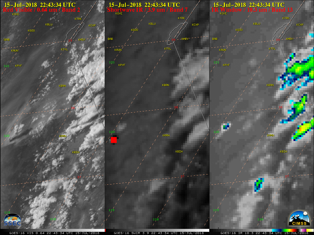
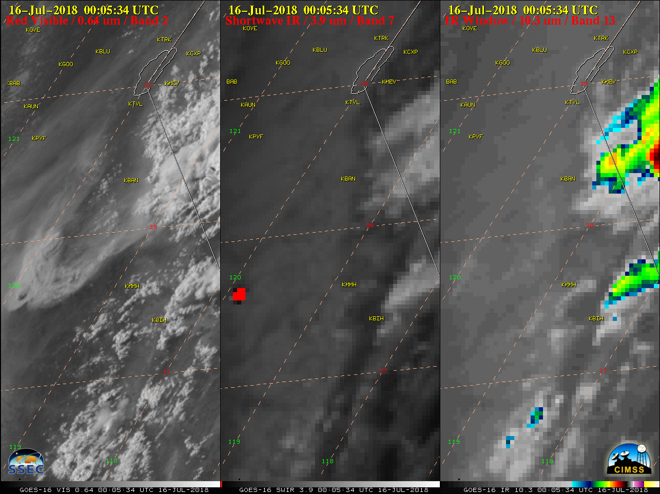
GOES-16 “Red” Visible (0.64 µm, left), Shortwave Infrared (3.9 µm, center) and “Clean” Infrared Window (10.3 µm, right) images [click to play MP4 animation]
* GOES-17 images shown here are preliminary and non-operational *
The Ferguson Fire in central California produced a pyrocumulonimbus (pyroCb) cloud during the afternoon hours on 15 July 2018. GOES-16 (GOES-East) “Red” Visible (0.64 µm), Shortwave Infrared (3.9 µm) and “Clean” Infrared Window (10.3 µm) images (above) showed that the high-altitude portion of the pyroCb cloud then drifted northeastward toward the California/Nevada border, where cloud-top infrared brightness temperatures cooled to near -55ºC (orange enhancement) as it crossed the border around 0005 UTC on 16 July.
A comparison of Visible images from GOES-15 (0.63 µm), GOES-17 (0.64 µm) and GOES-16 (0.64 µm) is shown below — with the imagery displayed in the native projection of each satellite. Images from GOES-16/17 are at 5-minute intervals, while images from GOES-15 are every 5-15 minutes depending on the operational scan schedule of that GOES-West satellite. GOES-17 was at its post-launch checkout position of 89.5ºW longitude, so it offered a more direct view of the pyroCb cloud.
![Visible images from GOES-15 (0.63 µm, left), GOES-17 (0.64 µm, center) and GOES-16 (0.64 µm, right) [click to play animation]](https://cimss.ssec.wisc.edu/satellite-blog/wp-content/uploads/sites/5/2018/07/180715_goes15_goes17_goes16_visible_Ferguson_Fire_CA_pyrocb_anim.gif)
Visible images from GOES-15 (0.63 µm, left), GOES-17 (0.64 µm, center) and GOES-16 (0.64 µm, right) [click to play animation]
![NOAA-19 Visible (0.63 µm), Shortwave Infrared (3.7 µm) and Infrared Window (10.8 µm) images [click to enlarge]](https://cimss.ssec.wisc.edu/satellite-blog/wp-content/uploads/sites/5/2018/07/180715_2327utc_noaa19_visible_shortwaveIR_IRwindow_Ferguson_Fire_CA_pyrocb_anim.gif)
NOAA-19 Visible (0.63 µm), Shortwave Infrared (3.7 µm) and Infrared Window (10.8 µm) images [click to enlarge]
![Time lapse [click to play YouTube video]](https://cimss.ssec.wisc.edu/satellite-blog/wp-content/uploads/sites/5/2018/07/180715_Ferguson_Fire_time_lapse_capture.jpeg)
Time lapse [click to play YouTube video]