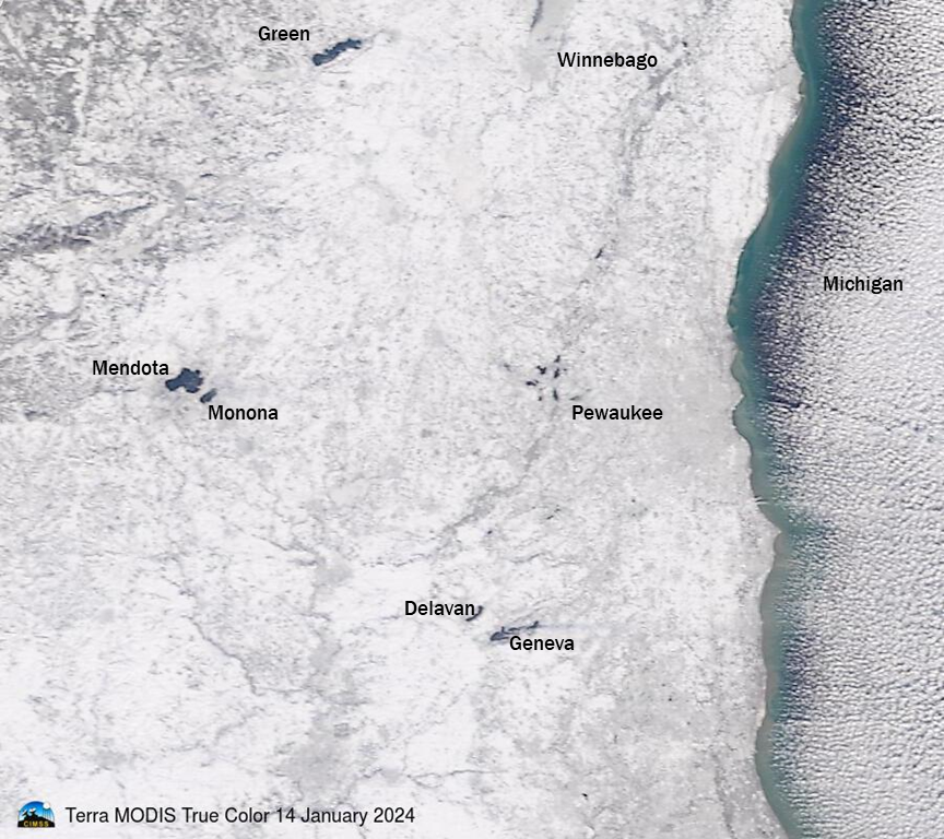
Tropical Storm Alberto

May 19th, 2012
AVHRR 10.8 µm, MODIS 11.0 µm, and VIIRS 11.45 µm IR images

AVHRR 10.8 µm, MODIS 11.0 µm, and VIIRS 11.45 µm IR images

The 2012 Atlantic Basin tropical cyclone season began with the formation of Tropical Storm Alberto off the coast of South Carolina on 19 May 2012. A sequence of AWIPS images of 1-km resolution POES AVHRR 10.8 µm, Terra/Aqua MODIS 11.0 µm, and Suomi NPP VIIRS 11.45 µm IR images (above) showed the growth of deep convecion associated with Alberto as the system moved southwestward — cloud top IR brightness temperatures were as cold as -72º C on the MODIS image at 16:03 UTC.

A comparison of the 18:27 UTC 1-km resolution Suomi NPP VIIRS 11.45 µm IR image with the 18:15 UTC 4-km resolution GOES-13 10.7 µm IR image (below) demonstrated the improvement in cloud top feature identification with higher spatial resolution, as well as showed the effect of parallax due to the large satellite viewing angle from GOES-13.

GOES-13 10.7 µm IR + Suomi NPP VIIRS 11.45 µm IR image

GOES-13 10.7 µm IR + Suomi NPP VIIRS 11.45 µm IR image

An animation of GOES-13 0.63 µm visible channel images from the CIMSS Tropical Cyclones site (below) showed the development of a more organized cloud structure during the day. In addition, a 21 UTC ship report near the center of Alberto noted wind gusts to 65 knots, which promted NHC to issue an update to note an increase in intensity.

GOES-13 0.63 µm visible channel images + Ship reports

GOES-13 0.63 µm visible channel images + Ship reports

========== 20 May Update ==========

An AWIPS night-time image of the Suomi NPP VIIRS 0.7 µm “Day/Night Band” (below) revealed some of the cloud structure associated with Tropical Storm Alberto at 06:45 UTC (2:45 am local time). Given that there was a “New Moon” phase at this time, not a great deal of reflected light was avaiable to allow the Day/Night Band imagery to show more cloud detail.

Lights from cities and towns across the far southeastern US could also be seen in the Day/Night Band image (although some of the urban area light signatures were attenuated somewhat by overhead cloud cover).

Suomi NPP VIIRS 0.7 µm Day/Night Band image

Suomi NPP VIIRS 0.7 µm Day/Night Band image

GOES-15 Super Rapid Scan Operations (SRSO) imagery

May 17th, 2012
GOES-15 0.63 µm visible channel images (click image to play animation)

GOES-15 0.63 µm visible channel images (click image to play animation)

The GOES-15 satellite was placed into Super Rapid Scan Operations (SRSO) mode on 17 May 2012, in support of the Deep Convective Clouds and Chemistry (DC3) field experiment. SRSO provides bursts of imagery at 1-minute intervals (compared to the standard operational 15-minute interval). McIDAS images of 1-km resolution GOES-15 0.63 µm visible channel data (above; click image to play animation) showed the development of widespread deep convection over Colorado and the adjacent states during the afternoon hours.

The cloud motions revealed the presence of a strong cyclonic circulation aloft over the region, which was verified by satellite-derived atmospheric motion vectors and NAM model 500 hPa heights plotted on an AWIPS image of MODIS 6.7 µm water vapor channel data at 19:35 UTC (below).

MODIS 6.7 µm water vapor image + Satellite atmospheric motion vectors + NAM 500 hPa height

MODIS 6.7 µm water vapor image + Satellite atmospheric motion vectors + NAM 500 hPa height

AWIPS images of 1-km resolution Suomi NPP VIIRS 11.45 µm, POES AVHRR 12.0 µm, and MODIS 11.0 µm IR channel data at 19:04, 19:14, and 19:35 UTC (below) revealed that cloud top IR brightness temperatures were as cold as -60 to -62 C (darker red color enhancement) with many of the stronger areas of convection.

VIIRS 11.45 µm, AVHRR 12.0 µm, and MODIS 11.0 µm IR channel images

VIIRS 11.45 µm, AVHRR 12.0 µm, and MODIS 11.0 µm IR channel images

Lake breeze boundary around Lake Superior

May 10th, 2012
MODIS Sea Surface Temperature product

MODIS Sea Surface Temperature product

An AWIPS image of the 1-km resolution MODIS Sea Surface Temperature (SST) product on 10 May 2012 (above) revealed that much of Lake Superior exhibited SST values in the 40s F (darker blue color enhancement), with the coldest SST value being 39.1 F off the coast of far northeastern Minnesota.

After several hours of daytime heating and generally light winds across the region, 1-km resolution GOES-13 0.63 µm visible channel images (below; click image to play animation) showed that a well-defined lake breeze boundary began to appear on the cumulus cloud field. Note that there was a similar lake breeze boundary seen surrounding Lake Nipigon in southern Ontario, Canada (where SST values were as low as 33.5 F).

GOES-13 0.63 µm visible channel images (click image to play animation)

GOES-13 0.63 µm visible channel images (click image to play animation)

A comparison of 1-km resolution MODIS visible channel, Land Surface Temperature (LST), and Normalized Difference Vegetation Index (NDVI) is shown below. LST values were generally in the 60s to 70s F surrounding Lake Superior, creating a large thermal contrast to the cold waters of the lake. To the northwest and southwest of Lake Superior, there were a number of areas exhibiting much warmer LST values (in the 80s  to around 90 F, darker red color enhancement) — and these areas of warmer LST values generally corresponded to features with a lower NDVI value. In particular, the large Pagami Creek wildfire burn scar (located east of Ely, Minnesota — station identifier KELO) had a maximum LST value of 96 F, with NDVI values less than 0.3 within the large burn scar.

MODIS 0.65 µm visible channel + Land Surface Temperature + Normalized Difference Vegetation Index

MODIS 0.65 µm visible channel + Land Surface Temperature + Normalized Difference Vegetation Index