Upper Midwest Severe Thunderstorm Outbreak
An outbreak of severe thunderstorms developed across the Upper Midwest states on 07 June 2007 — SPC storm reports showed widespread tornadoes (including the EF-3 Langlade WI tornado), large hail, and damaging winds over much of the region. GOES-12 Visible (0.65 µm) images (above; click to play animation) revealed a large area of boundary layer wave clouds that developed during the morning hours over a good deal of western Wisconsin and extreme northeastern Iowa and southeastern Minnesota.GOES-12 Infrared (10.7 µm) images (below; click to play animation) depicted cloud top brightness temperatures as cold as -69º C / -92º F (dark red enhancement) as the storms intensified during the afternoon. The dynamics associated with this severe weather outbreak were quite strong, with very fast jet stream winds at the 500 hPa and 250 hPa pressure levels. The 1-km resolution MODIS 6.7 µm water vapor imagery indicated a broad area of potential clear air turbulence downwind of the Rocky Mountains, with the characteristic “herringbone signature” extending as far eastward as western Kansas.
CIMSS employee Derrick Herndon was chasing these storms in central Wisconsin, and took a photo of some very large hail near Wisconsin Rapids (below). The largest hail listed on the SPC storm reports for that day was 4.25 inches in diameter at Wisconsin Rapids.![Hail near Wisconsin Rapids [click to enlarge]](https://cimss.ssec.wisc.edu/satellite-blog/wp-content/uploads/sites/5/2007//06/070607_hail_WI_Rapids.jpg)
Hail near Wisconsin Rapids [click to enlarge]
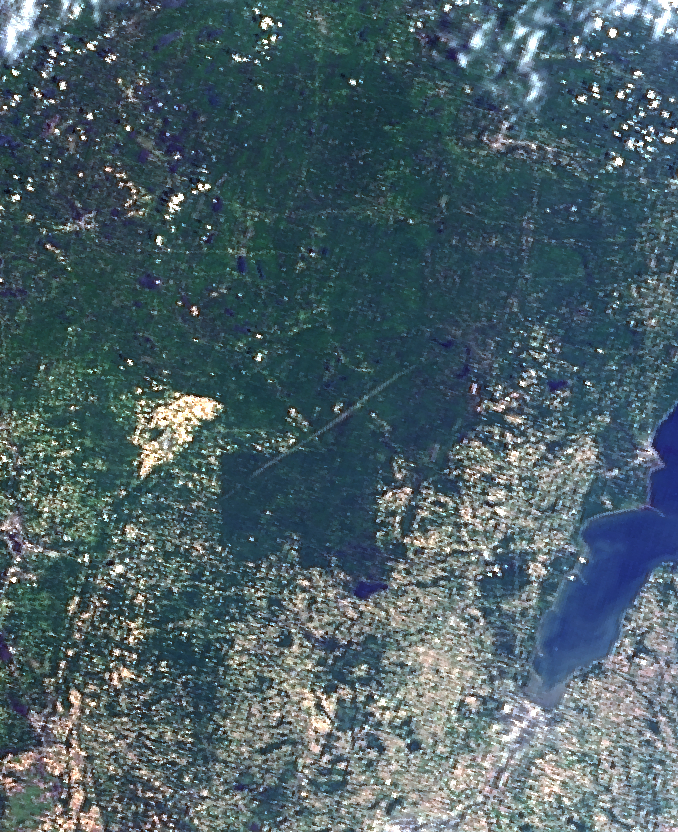
2 days later (on 09 June), the long-track tornado damage path across northeastern Wisconsin was very evident on a Terra MODIS true-color image (below), courtesy of the Environmental Remote Sensing Center.
===== 07 June 2017 Update =====
On the 10-year anniversary of this event, a storm summary was published by NWS Green Bay. The tornado damage path was still evident on monthly Aqua MODIS true-color Red/Green/Blue (RGB) images from 06 January to 07 June 2017 (below). Previous blog posts had shown this tornado damage path on 15 July 2015 and 03 December 2007.


![MODIS true-color RGB images [clck to enlarge]](https://cimss.ssec.wisc.edu/satellite-blog/wp-content/uploads/sites/5/2017/06/1701-1706_modis_truecolor_WI_tornado_damage_path_anim.gif)