
GOES-14 10.7 µm IR images
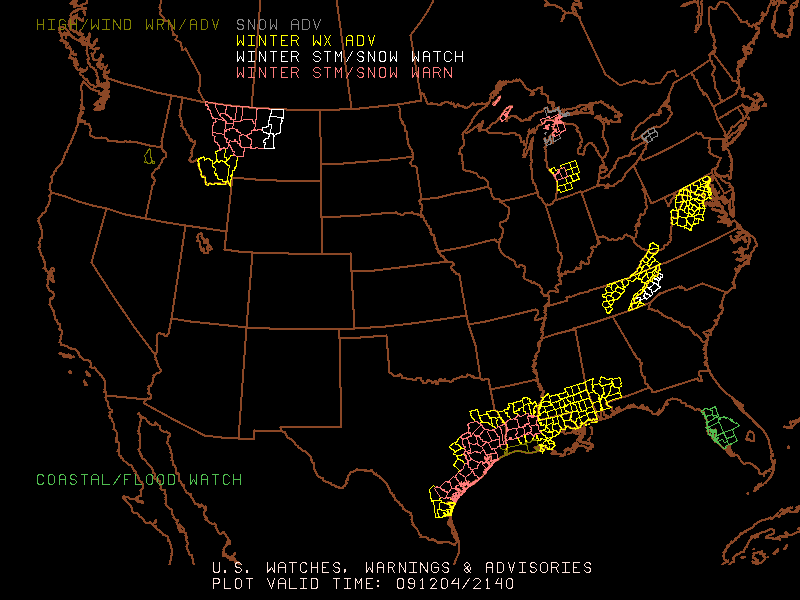
An historic snowfall event (SPC watches and warnings) impacted parts of the Gulf Coast region of the US on 04 December 2009 — this event produced the earliest snowfall on record at both Houston, Texas and Lake Charles, Louisiana, and total snowfall amounts were as high as 5.0 inches in Mississippi, 4.0 inches in Texas, and 3.0 inches in Louisiana. McIDAS images of the GOES-14 10.7 µm IR channel data (above) showed the development of the bands of elevated convection that produced the snowfall (the symbols of precipitation type are also plotted on the IR images).
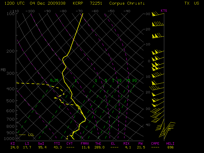
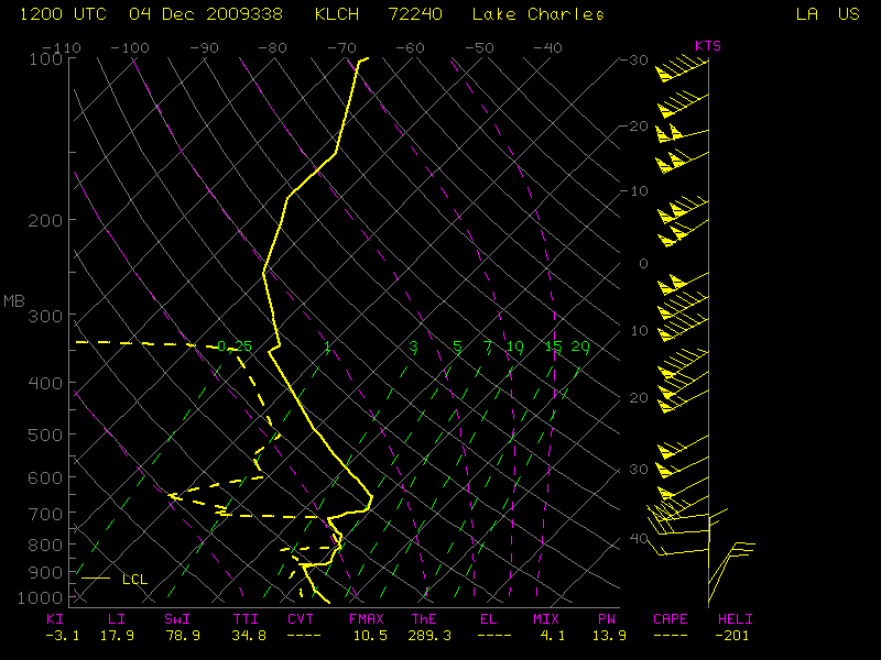
AWIPS images of the GOES-12 10.7 µm IR channel data with overlays of surface METAR reports and cloud-to-ground lightning strikes (below) did indicate that there were a few lightning strikes early in the development of the bands of elevated convection over far southeast Texas (with a small number of strikes immediately offshore later in the morning), but as the snowfall event was unfolding farther north toward the Houston area there were no cloud-to-ground strikes seen. GOES-14 and GOES-12 IR cloud top brightness temperatures were in the -40 to -50º C range, which was near the tropopause on the Corpus Christi, Texas and Lake Charles, Louisiana rawinsonde data.

GOES-12 10.7 µm IR images + METARs + Cloud-to-Ground Lightning
1-km resolution MODIS visible channel, 2.1 µm near-IR “snow/ice channel”, and 11.0 µm IR channel images (below) offered a view of the event at 16:58 UTC or 10:58 AM local time. Shadows from the tall convective elements could be seen on the visible image — and since the tops of the elevated convection were glaciated, they showed up as darker features on the snow/ice image. As was seen on the GOES-12 and GOES-14 IR images above, the IR cloud top brightness temperatures were in the -40 to -50º C range.

MODIS visible, 2,1 µm near-IR "snow/ice", and 11.0 µm IR channel images
1-km resolution AVHRR cloud products at 20:11 UTC or 2:11 PM local time (below) showed that the glaciated cirrus cloud type elements (red enhancement) had cloud top heights in the 9-10 km range (cyan color enhancement), with cloud top temperatures in the -40 to -50º C range (darker blue enhancement).

AVHRR Cloud Type, Cloud Top Height, and Cloud Top Temperature products
UPDATE: On the following morning, GOES-14 visible images (below) revealed the areal extent of the resulting snow cover that had not yet melted. Note the brighter white band of deeper snow cover near the Texas coast, where Lane City and Boling had received 4.0 inches. Some of the bright features seen in southwestern Louisiana were low stratiform clouds that were burning off as daytime heating increased.

GOES-14 visible images
")
MODIS true color image (displayed using Google Earth)
MODIS true color images (displayed using Google Earth) showed another view of the remaining snow cover on the late morning hours on 05 December over Texas (above) and over Louisiana and Mississippi (below). The highest snowfall totals reported in each region are noted on the images.
")
MODIS true color image (displayed using Google Earth)
View only this post Read Less


