This website works best with a newer web browser such as Chrome, Firefox, Safari or Microsoft Edge. Internet Explorer is not supported by this website.

Of large eyes and midget tropical cyclones

GOES-13 visible imagery (above) revealed the rather large eye of Hurricane Norbert on 08 October 2008 — Norbert was a Category 4 storm at that time, and the eye appeared to be about 30-35 nautical... Read More

GOES-13 visible images (Hurricane Norbert)

GOES-13 visible images (Hurricane Norbert)

GOES-13 visible imagery (above) revealed the rather large eye of Hurricane Norbert on 08 October 2008 — Norbert was a Category 4 storm at that time, and the eye appeared to be about 30-35 nautical miles in diameter.  Hurricane Norbert underwent a period of rapid intensification during the pre-dawn hours on 08 October, which was clearly seen on a plot of the Advanced Dvorak Technique intensity estimate (below) from the CIMSS Tropical Cyclones site.

CIMSS Advanced Dvorak Technique

CIMSS Advanced Dvorak Technique

To illustrate the diversity of tropical cyclone spatial scales, it is interesting to compare the large eye of Hurricane Norbert (in the eastern Pacific Ocean) with the small cluster of deep convection around the core of Tropical Storm Marco (2 days earlier in the Gulf of Mexico) — Marco is not much larger than the eye of Norbert! The visible and IR images shown below are from the same satellite (GOES-13) at the same time of day (20:00 UTC), displayed with the same magnification (zoomed in to an effective 0.5 km resolution). According to the National Hurricane Center discussions, Tropical Storm Marco may have been one of the smallest tropical cyclones on record, with tropical storm force winds only extending about 10 nautical miles away from the center.

GOES-13 visible images (Hurricane Norbert and Tropical Storm Marco)

GOES-13 visible images (Hurricane Norbert and Tropical Storm Marco)

GOES-13 IR images (Hurricane Norbert and Tropical Storm Marco)

GOES-13 IR images (Hurricane Norbert and Tropical Storm Marco)

View only this post Read Less

River valley fog in the Northeast US

AWIPS images of the GOES-12 and MODIS fog/stratus product around 07:30 UTC or 3:30 AM local time   (above) told two very different stories regarding the formation of river valley fog across parts of the Northeast US on 07 October 2008. In... Read More

AWIPS images of GOES and MODIS fog/stratus product

AWIPS images of GOES and MODIS fog/stratus product

AWIPS images of the GOES-12 and MODIS fog/stratus product around 07:30 UTC or 3:30 AM local time   (above) told two very different stories regarding the formation of river valley fog across parts of the Northeast US on 07 October 2008. In general, there was a surprising amount of disagreement between to two images: the 4-km resolution GOES-12 fog/stratus product suggested that fog was forming over places like the Finger Lakes region of New York and the Lake Champlain region along the Vermont/New York border, while the 1-km resolution MODIS fog/stratus product indicated significant areas of river valley fog across parts of northern Pennsylvania into southern New York.

A closer view (below) helps to illustrate the problem of fog/stratus product verification — there was a lack of reporting stations in the actual areas where river valley fog was forming.

AWIPS images of GOES and MODIS fog/stratus product

AWIPS images of GOES and MODIS fog/stratus product

A 1-km resolution NOAA-15 AVHRR fog/stratus product (below) from a few hours later (11:10 UTC or 7:10 AM local time) indicated that the fingers of river valley fog across northern Pennsylvania and southern New York had increased in the hours leading up to sunrise.

NOAA-15 fog/stratus product

NOAA-15 fog/stratus product

Post-sunrise GOES-12 and GOES-13 visible images (below) revealed the widespread coverage of river valley fog across the Pennsylvania/New York border region, which dissipated rather quickly by 15:00 UTC or 11 AM local time.

GOES-12 and GOES-13 visible images

GOES-12 and GOES-13 visible images

View only this post Read Less
Pacific moisture plume and strong jet

AWIPS images of geostationary satellite water vapor channel data (above) showed a long moisture plume moving across the Pacific Ocean toward the west coast of the US on 02-03 October 2008. A comparison of GOES-11 water vapor channel data with POES (AMSU) and SSM/I Total Precipitable Water (TPW) products (below)... Read More

AWIPS images of water vapor composite

AWIPS images of geostationary satellite water vapor channel data

AWIPS images of geostationary satellite water vapor channel data (above) showed a long moisture plume moving across the Pacific Ocean toward the west coast of the US on 02-03 October 2008. A comparison of GOES-11 water vapor channel data with POES (AMSU) and SSM/I Total Precipitable Water (TPW) products (below) revealed that TPW values were as high as 50-60 mm (2.0-2.4 inches) within this moisture plume. The MIMIC TPW product suggested that this moisture plume originated over the western Pacific Ocean, southeast of Japan.

AWIPS images of POES TPW products and GOES water vapor channel

AWIPS images of POES TPW products and GOES water vapor channel

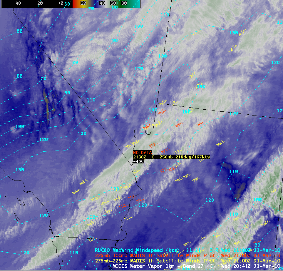
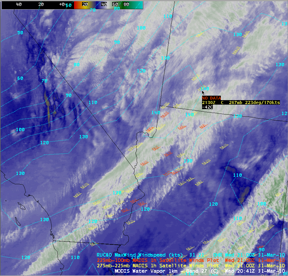
This moisture plume was associated with a strong polar jet stream, as seen by an overlay of hourly MADIS atmospheric motion vectors on GOES water vapor channel imagery (below).

GOES water vapor images + MADIS winds

GOES water vapor images + MADIS winds

The 18 UTC GFS model fields were forecasting maximum winds in the core of the jet to reach 170 knots (below) — there were a few MADIS wind vectors with speeds of 177-181 knots around that time (and a MADIS wind vector with a speed of 191 knots was seen at 21 UTC).

GFS winds + MADIS winds

GFS winds + MADIS winds

View only this post Read Less
Stratus clouds in central Canada

A patch of stratus cloud was easily identifiable on AWIPS images of the GOES-12 and MODIS fog/stratus product (above) across parts of eastern Saskatchewan and western Manitoba in central Canada on 02 October 2008. Note how much sharper the cloud edge appeared... Read More

AWIPS images of the GOES-12 and MODIS fog/stratus product

AWIPS images of the GOES-12 and MODIS fog/stratus product

A patch of stratus cloud was easily identifiable on AWIPS images of the GOES-12 and MODIS fog/stratus product (above) across parts of eastern Saskatchewan and western Manitoba in central Canada on 02 October 2008. Note how much sharper the cloud edge appeared on the 1-km resolution MODIS image compared to the 4-km resolution GOES-12 image.

MODIS Cloud Top Temperature, Cloud Phase, and GOES-12 Low Cloud Base products

MODIS Cloud Top Temperature, Cloud Phase, and GOES-12 Low Cloud Base products

Other AWIPS satellite products such as the MODIS Cloud Top Temperature and Cloud Phase, and the GOES-12 Low Cloud Base (above) indicated that this particular stratus cloud feature would likely not have posed a hazard to aircraft icing, given that the cloud phase was water droplets which exhibited cloud top temperatures  in the +3 to +6º C range. The lowest cloud bases appeared to be along the western portions of the stratus feature, which was confirmed by a ceiling report of 400 feet above ground level at Key Lake, Saskatchewan (station identifier CYKJ) versus 800 feet at The Pas, Manitoba (station identifier CYQD).

GOES-12 and GOES-13 visible images

GOES-12 and GOES-13 visible images

The daytime dissipation of this area of stratus cloud could then be monitored using visible channel imagery from GOES-12 and GOES-13 (above). The stratus deck burned off over the Key Lake (CYKJ) area around 18:00 UTC (Noon local time). Note that the surface features on the GOES-13 animations exhibit less image-to-image movement compared to GOES-12 — improvements to the GOES-13 spacecraft Image Navigation and Registration (INR) system  include the use of star trackers to provide more precise image navigation.

Lake Athabasca (which staddles the Alberta/Saskatchewan border region) was seen in the upper left portion of the GOES-12 imagery, due to the different viewing angle from that satellite — note the brighter white features along parts of the southern shore of the lake. The initial question of “Could those bright white features be ice that had formed in the lake?”  was addressed by examining a 4-panel comparison of MODIS Visible, Snow/Ice, Land Surface Temperature, and Sea Surface Temperature (below); ice would have exhibited a darker signal on the 1.6 µm near-IR Snow/Ice image, but this feature was brighter white on both the Visible and the Snow/Ice images. In addition, the MODIS sea surface temperatures in the lake were in the mid 40s F (green colors), which argues against ice formation.

MODIS Visible, Snow/ice, Land Surface Temperature, Sea Surface Temperature

MODIS Visible, Snow/ice, Land Surface Temperature, Sea Surface Temperature

A quick look at a map of the area provided the complete answer: the brighter white features seen along the southern shore of the lake are actually Athabasca Sand Dunes Provincial Park.

View only this post Read Less