The third major storm of the 2010/2011 winter season (storm #1 | storm #2) impacted much of the Mid-Atlantic and Northeast states on 26 January 2011 – 27 January 2011. An AWIPS image of Read More

MODIS 6.7 µm water vapor image
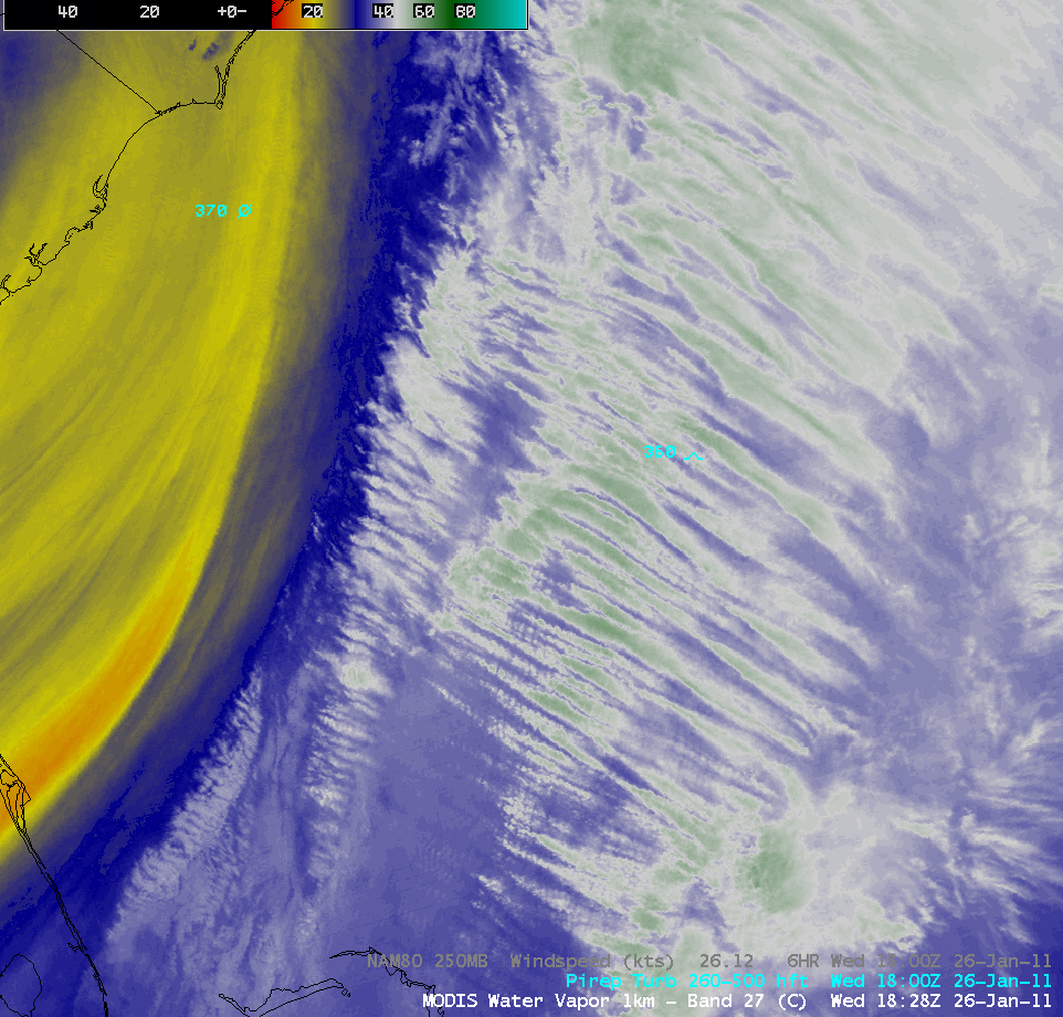
The third major storm of the 2010/2011 winter season (storm #1 | storm #2) impacted much of the Mid-Atlantic and Northeast states on 26 January 2011 – 27 January 2011. An AWIPS image of MODIS 6.7 µm water vapor channel data at 18:28 UTC (above) revealed a large and complex dry slot, with convective elements developing ahead of the leading edge of the dry slot across Virginia. In addition, to the east of the dry slot over the western Atlantic Ocean a well-defined packet of high altitude “transverse bands” was seen (close-up view) which was forming in the right entrance region of an upper level jet streak.
On a POES AVHRR false-color Red/Green/Blue (RGB) image at that same time (below), high cloud features appeared brighter white, with low clouds taking on a slight yellow tint.
 false color image")
POES AVHRR Red/Green/Blue (RGB) false color image
An animation of GOES-13 10.7 µm IR images (below; click image to play animation) showed the development of the transverse banding cloud structures — the bands were oriented perpendicular to the southwesterly high-altitude wind flow over that region. This transverse banding pattern is a cloud signature that is often associated with areas of turbulence — and in this case there were two pilot reports of moderate turbulence at altitudes of 34,000 feet and 36,000 feet.
")
GOES-13 10.7 µm IR images (click image to play animation)
A comparison of a GOES-13 10.7 µm IR image with the corresponding MODIS 11.0 µm IR image (below) demonstrated the advantage of higher spatial resolution, with the fine transverse band structure more apparent on the 1-km resolution MODIS image. The coldest IR brightness temperatures within the bands on the MODIS image were -58º C (red color enhancement).

MODIS 11.0 µm IR + GOES-13 10.7 µm IR images
A number of cloud-to-ground lightning strikes were associated with the convective elements that had formed over Virginia (below), ahead of the leading edge of the dry slot that was seen on water vapor imagery. Thundersnow was reported across a wide portion of the Mid-Atlantic and Northeast states, with snowfall rates as high as 1-4 inches per hour at some locations.

MODIS 11.0 µm IR image + lightning strikes + METAR surface reports
=========== 27 JANUARY UPDATE ===========
")
MIMIC Total Precipitable Water product (click image to play animation)
This storm was not particularly intense in terms of a low central pressure or strong winds, but it was able to tap a significant plume of deep moisture (in excess of 30-40 mm or 1.2-1.6 inches) from the Gulf of Mexico and the Caribbean, as can be seen on AWIPS images of the MIMIC Total Precipitable Water (TPW) product (above; click image to play animation) and the Blended Total Precipitable Water product (below; click image to play animation). This contributed to the high snowfall totals at many locations (Weather Underground blog| WeatherMatrix blog).
")
Blended Total Precipitable Water product (click image to play animation)
Parts of this plume of moisture represented TPW values in excess of 200% of normal (below; click image to play animation).
")
Percent of Normal TPW product (click image to play animation)
View only this post
Read Less
")


")
")
")
")


 images (Green Bay WI region)")
 images (Milwaukee WI and Chicago IL region)")
 images")
