This website works best with a newer web browser such as Chrome, Firefox, Safari or Microsoft Edge. Internet Explorer is not supported by this website.

“Groundhog Day” Blizzard of of 01-02 February 2011

 AWIPS images of GOES-13 6.5 µm water vapor channel data (above; click image to play an animated GIF; also available as a QuickTime movie) showed the evolution of the “Groundhog Day Blizzard” of 01 February... Read More


GOES-13 6.5 µm water vapor imagery (click on image to play animation)

GOES-13 6.5 µm water vapor imagery (click on image to play animation)

AWIPS images of GOES-13 6.5 µm water vapor channel data (above; click image to play an animated GIF; also available as a QuickTime movie) showed the evolution of the “Groundhog Day Blizzard” of 01 February 02 February 2011. This was a particularly large storm, impacting a swath of the US over 2500 miles long and 700 miles wide with snow, sleet, and ice from New Mexico to Maine — snowfall amounts were as high as 27.0 inches at Antioch, Illinois (HPC storm summary). As the storm developed, the water vapor imagery displayed a very pronounced dry slot, along with an extensive cloud shield.

MODIS 6.7 µm water vapor image

MODIS 6.7 µm water vapor image

With  higher spatial resolution (1 km) MODIS water vapor imagery, several interesting details could be seen, such as bands of convection in Texas (above) and “lee waves” within the dry slot, downwind of the areas of higher terrain on northern Arkansas and southern Missouri (below).

MODIS 6.7 µm water vapor image

MODIS 6.7 µm water vapor image

One area that was hit particularly hard with heavy snow and blizzard conditions was northern Illinois (NWS Chicago summary) and southeastern Wisconsin (NWS Milwaukee summary) — in the Chicago area, the 20.1 inches of snow at O’Hare airport and 20.9 inches at Midway airport were the third largest snowfall amounts on record. Thundersnow was reported at a number of locations, where accompanying snowfall rates were several inches per hour; much of the lightning was likely in-cloud and/or cloud-to-cloud, but there were  several cloud-to-ground lightning strikes seen overlaid on GOES-13 10.7 µm IR images  (below; click image to play animation).


GOES-13 10.7 µm IR images + lightning (click image to play animation)

GOES-13 10.7 µm IR images + lightning (click image to play animation)

=========== 03 February Update ==========


MODIS true color and false color images


In the aftermath of the winter storm, a comparison of MODIS true color and false color images from the SSEC MODIS Today site (above) showed extensive snow cover across the Upper Midwest region, along with ice forming in parts of Lake Michigan, Lake Huron, and most of Lake Erie (snow and ice appear as shades of cyan on the MODIS false color image, in contrast to supercooled water droplet clouds which are brighter white features). In fact, some movement of the ice features in the Great Lakes could be seen — especially in Lake Erie –  in a comparison of MODIS false color images from the Terra satellite overpass at 16:03 UTC and the Aqua overpass at 19:23 UTC (below), due to brisk southwesterly surface winds across the region.


Terra and Aqua MODIS false color images


View only this post Read Less

Occluding cyclone over the eastern North Pacific Ocean

An animation of 8-km resolution GOES-11 6.7 µm “water vapor channel” images (above; click image to play animation) revealed a mid-latitude cyclone over the eastern North Pacific Ocean on 28 January29 January 2011 —... Read More

GOES-11 6.7 µm water vapor channel images (click image to play animation)

GOES-11 6.7 µm water vapor channel images (click image to play animation)

An animation of 8-km resolution GOES-11 6.7 µm “water vapor channel” images (above; click image to play animation) revealed a mid-latitude cyclone over the eastern North Pacific Ocean on 28 January29 January 2011 — and this cyclone was reaching the occluded stage of its life cycle, as seen by the classic water vapor image signature of dry air wrapping into the center of the circulation.

AWIPS images of the 10-km resolution GOES-11 sounder Total Column Ozone product (below) showed there were elevated levels of ozone (350 to 400 Dobson Units, green to red color enhancement) associated with this occluding cyclone.

GOES-11 sounder Total Column Ozone images

GOES-11 sounder Total Column Ozone images

An AWIPS comparison of the 1-km resolution MODIS 6.7 µm water vapor image with the corresponding 8-km resolution GOES-11 6.7 µm water vapor image  (below) demonstrated the advantage of higher spatial resolution for visualizing some of the finer details of the cyclone structure.

MODIS 6.7 µm and GOES-11 6.7 µm water vapor images

MODIS 6.7 µm and GOES-11 6.7 µm water vapor images

View only this post Read Less

Yet another Northeast US winter storm

The third major storm  of the 2010/2011 winter season  (storm #1 | storm #2) impacted much of the Mid-Atlantic and Northeast states on 26 January 2011 – 27 January 2011. An AWIPS image  of Read More

MODIS 6.7 µm water vapor image

MODIS 6.7 µm water vapor image

The third major storm  of the 2010/2011 winter season  (storm #1 | storm #2) impacted much of the Mid-Atlantic and Northeast states on 26 January 2011 27 January 2011. An AWIPS image  of MODIS 6.7 µm water vapor channel data at 18:28 UTC  (above) revealed a large and complex dry slot, with convective elements developing ahead of the leading edge of the dry slot across Virginia. In addition, to the east of the dry slot over the western Atlantic Ocean a well-defined packet of high altitude “transverse bands” was seen (close-up view) which was forming in the right entrance region of an upper level jet streak.

On a POES AVHRR false-color Red/Green/Blue (RGB) image at that same time (below), high cloud features appeared brighter white, with low clouds taking on a slight yellow tint.

POES AVHRR Red/Green/Blue (RGB) false color image

POES AVHRR Red/Green/Blue (RGB) false color image

An animation of GOES-13 10.7 µm IR images (below; click image to play animation) showed the development of the transverse banding cloud structures — the bands were oriented perpendicular to the southwesterly high-altitude wind flow over that region. This transverse banding pattern is a cloud signature that is often associated with areas of turbulence — and in this case there were two pilot reports of moderate turbulence at altitudes of 34,000 feet and 36,000 feet.

GOES-13 10.7 µm IR images (click image to play animation)

GOES-13 10.7 µm IR images (click image to play animation)

A comparison of a GOES-13 10.7 µm IR image with the corresponding MODIS 11.0 µm IR image (below) demonstrated the advantage of higher spatial resolution, with the fine transverse band structure more apparent on the 1-km resolution MODIS image. The coldest IR brightness temperatures within the bands on the MODIS image were -58º C (red color enhancement).

MODIS 11.0 µm IR + GOES-13 10.7 µm IR images

MODIS 11.0 µm IR + GOES-13 10.7 µm IR images

A number of cloud-to-ground lightning strikes were associated with the convective elements that had formed over Virginia (below), ahead of the leading edge of the dry slot that was seen on water vapor imagery. Thundersnow was reported across a wide portion of the Mid-Atlantic and Northeast states, with snowfall rates as high as 1-4 inches per hour at some locations.

MODIS 11.0 µm IR image + lightning strikes + METAR surface reports

MODIS 11.0 µm IR image + lightning strikes + METAR surface reports

=========== 27 JANUARY UPDATE ===========

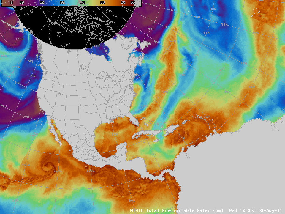
MIMIC Total Precipitable Water product (click image to play animation)

MIMIC Total Precipitable Water product (click image to play animation)

This storm was not particularly intense in terms of a low central pressure or strong winds, but it was able to tap a significant plume of deep moisture (in excess of 30-40 mm or 1.2-1.6 inches) from the Gulf of Mexico and the Caribbean, as can be seen on AWIPS images of the MIMIC Total Precipitable Water (TPW) product (above; click image to play animation) and the Blended Total Precipitable Water product (below; click image to play animation). This contributed to the high snowfall totals at many locations (Weather Underground blog| WeatherMatrix blog).

Blended Total Precipitable Water product (click image to play animation)

Blended Total Precipitable Water product (click image to play animation)

Parts of this plume of moisture represented TPW values in excess of 200% of normal (below; click image to play animation).

Percent of Normal TPW product (click image to play animation)

Percent of Normal TPW product (click image to play animation)

View only this post Read Less

The “warming effects” of the Arctic Ocean

The North Slope region of far northern Alaska had been abnormally cold for a number of days in late January 2011: for example, Barrow had minimum temperatures of -43ºF / -42ºC and -45ºF / -43ºC on 23 January and 24 January, respectively (the normal low temperature on those days is... Read More

POES AVHRR 12.0 µm IR images

POES AVHRR 12.0 µm IR images

The North Slope region of far northern Alaska had been abnormally cold for a number of days in late January 2011: for example, Barrow had minimum temperatures of -43ºF / -42ºC and -45ºF / -43ºC on 23 January and 24 January, respectively (the normal low temperature on those days is -20ºF/-29ºC). While the sun actually rose at Barrow on 23 January for the first time in 2011 (from 1:05 pm to 2:14 pm local time), it had little effect on warming the temperatures there (which were around -40ºF/-40ºC at the time).

However, a sequence of AWIPS images of POES AVHRR 12.0 µm IR data (above) revealed something that did appear to have a pronounced effect on the warming of surface air temperatures at Barrow: a shift of winds from southerly (offshore, from the cold interior) on 24 January 2011 to northeasterly (onshore, from off the Arctic Ocean) on 25 January 2011.  Around the same time as the northeasterly wind shift, a number of long, narrow features — resembling large “cracks” in the sea ice — began to exhibit significantly warmer IR brightness temperatures (-20º to -30ºC, yellow to orange color enhancement) just offshore of Barrow. Apparently a great deal of heat was able to “bleed upward” through these thinner areas of sea ice, which was then transported toward the coast of Alaska by northeasterly winds.

Although the temperature at Barrow (station identifier PABR) rose to -24ºF / -31ºC by 15:09 UTC on 25 January, farther to the southeast the temperature at Nuiqsut (station identifier PAQT) remained at a very cold -51ºF / -46ºC. Note that North is to the upper right, due to the AWIPS “North America” projection of these particular images.

The much larger yellow to orange colored features seen across the interior of Alaska and also over parts of the Arctic Ocean were clouds. The purple colored areas farther inland were regions that exhibited surface IR brightness temperatures of -47ºC or colder.

View only this post Read Less