This website works best with a newer web browser such as Chrome, Firefox, Safari or Microsoft Edge. Internet Explorer is not supported by this website.

Super Rapid Scan Operations (SRSO) images of Tropical Storm Don

The GOES-R Proving Ground requested that the GOES-13 satellite be placed into Super Rapid Scan Operations (SRSO) mode to monitor the development of Tropical Storm Don as it approached the far southern coast of Texas on 29 July 2011:Subject: Administrative, GOES-13 (GOES-East) SRSO scheduled for July 29 *Topic*: GOES-13 (GOES-East) SRSO is scheduled for: July 29,... Read More

GOES-13 0.63 µm visible channel images (click image to play animation)

GOES-13 0.63 µm visible channel images (click image to play animation)

The GOES-R Proving Ground requested that the GOES-13 satellite be placed into Super Rapid Scan Operations (SRSO) mode to monitor the development of Tropical Storm Don as it approached the far southern coast of Texas on 29 July 2011:

Subject: Administrative, GOES-13 (GOES-East) SRSO scheduled for July 29

*Topic*: GOES-13 (GOES-East) SRSO is scheduled for: July 29, 2011

*Correction*: *Product(s) or Data Impacted:* GOES-13 (GOES-East)
Imager Data and Products

*Date/Time Issued*: July 29, 2011 1705 UTC

*Product(s) or Data Impacted:* GOES-13 (GOES-West) Imager Data and
Products

*Date/Time of Initial Impact*: July 29, 2011 J/date 210 1815 UTC

*Date/Time of Expected End*: July 29, 2011 J/date 211 0115 UTC

*Length of Event*: 7 hours

*Impacts on Users and Significance*: Smaller PACUS frame with shortened Southern Hemisphere scan (Southern Hemisphere scan hourly). Increased frequency of images over area of interest (see Details)

*User Actions*: None.

*Details/Specifics of Change*: GOES-R Proving Grounds Testing Over Tropical Storm Don in the Gulf of Mexico at 27 North and 96 West

*Requestor: *CIRA

McIDAS images of GOES-13 0.63 µm visible channel data (above; click image to play animation; also available as a QuickTime movie) showed a number of convective bursts associated with the tropical storm — note that there were several periods where images were available at 1-minute intervals while GOES-13 was in SRSO mode. The ABI instrument on GOES-R will actually be able to provide images as frequently as every 30 seconds over special regions of interest (such as tropical cyclones or severe thunderstorms).

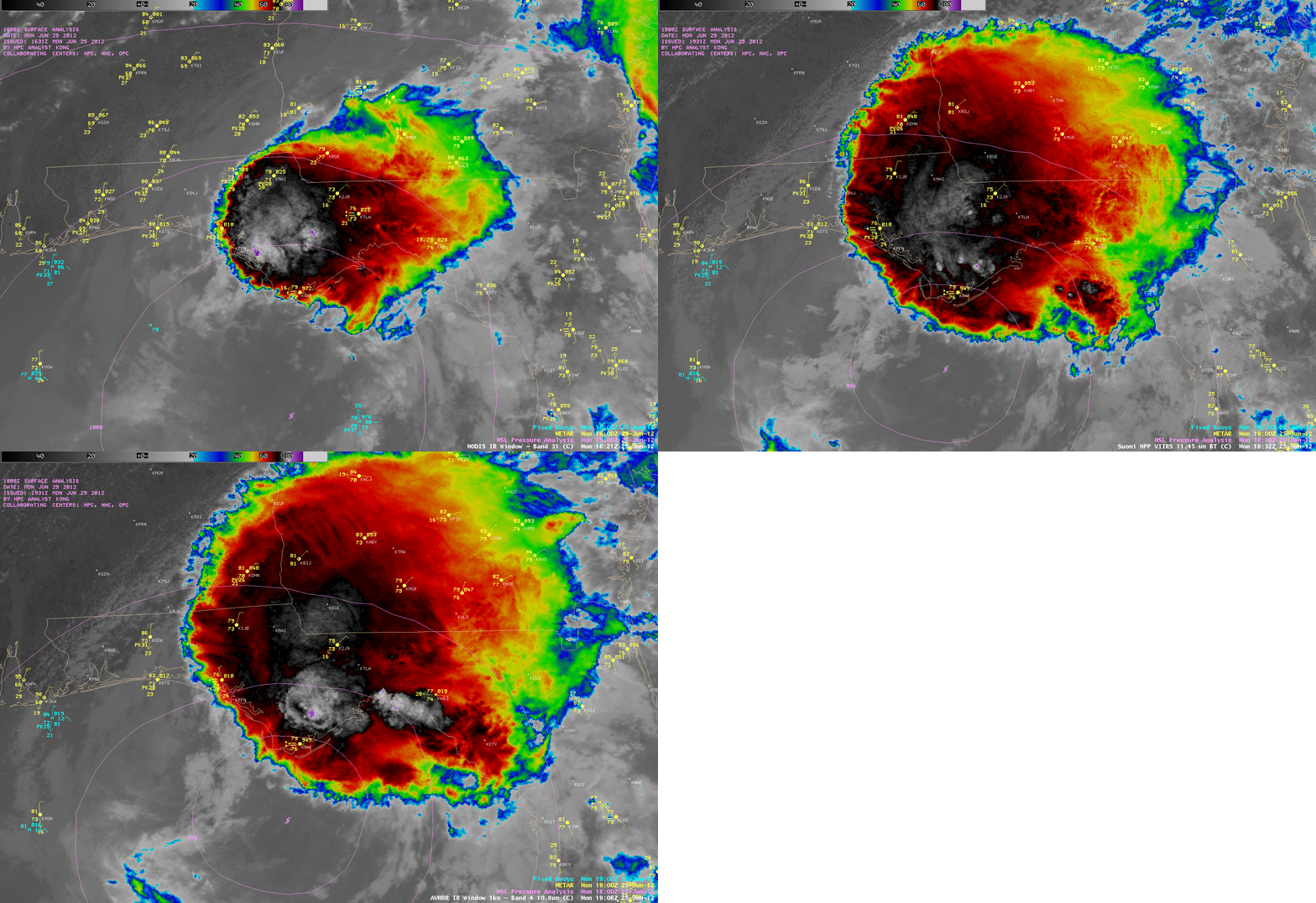
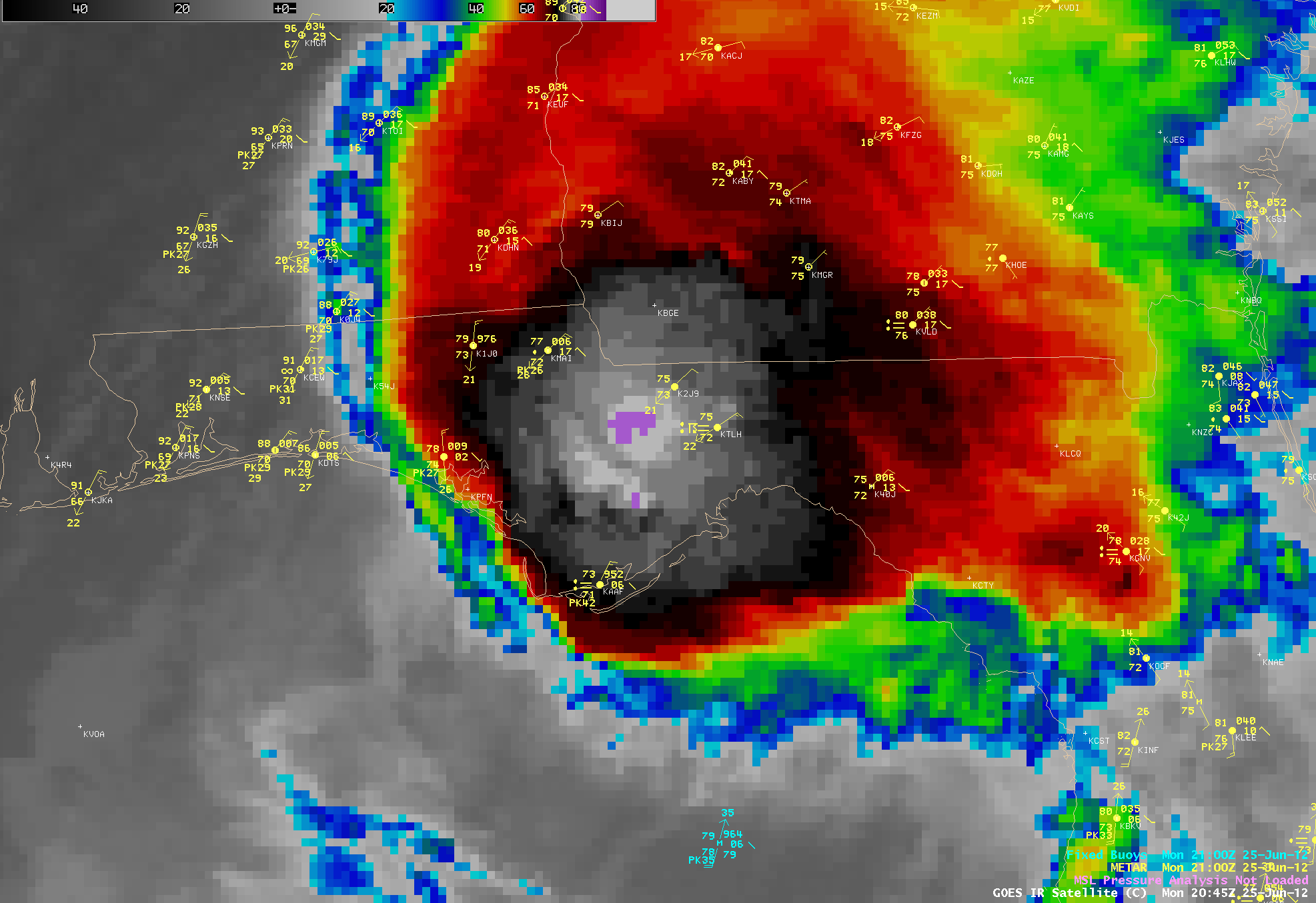
A sequence of three AWIPS images of 1-km resolution MODIS and POES AVHRR IR data (below) displayed intricate cloud top structures and very cold cloud top IR brightness temperatures — as cold as -90ºC (darker violet color enhancement) on the 14:23 UTC MODIS image and the 20:21 UTC POES AVHRR image.

MODIS 11.0 µm and POES AVHRR 10.8 µm IR images

MODIS 11.0 µm and POES AVHRR 10.8 µm IR images

For the three individual 1-km resolution MODIS and POES AVHRR IR images above, comparisons with the corresponding 4-km resolution GOES-13 IR images are shown below. There are slight time differences between the MODIS/AVHRR IR and the GOES-13 IR images — but the majority of the northwestward shift in the location of features on the GOES images is due to parallax.

Even though the spatial resolution of the IR channels on the ABI instrument on GOES-R will be 2-km, these 1-km resolution comparisons still serve to demonstrate that improved spatial resolution should allow better detection of such detailed cloud top structures and cold cloud top IR brightness temperatures associated with tropical cyclones.

08:09 UTC MODIS 11.0 µm IR and 08:15 UTC GOES-13 10.7 µm IR images

08:09 UTC MODIS 11.0 µm IR and 08:15 UTC GOES-13 10.7 µm IR images

14:23 UTC POES AVHRR 10.8 µm IR image and 14:32 UTC GOES-13 10.7 µm IR image

14:23 UTC POES AVHRR 10.8 µm IR image and 14:32 UTC GOES-13 10.7 µm IR image

20:21 UTC POES AVHRR 10.8 µm IR image and 20:30 UTC GOES-13 10.7 µm IR image

20:21 UTC POES AVHRR 10.8 µm IR image and 20:30 UTC GOES-13 10.7 µm IR image

View only this post Read Less

Tropical Storm Don Forms in the Gulf of Mexico

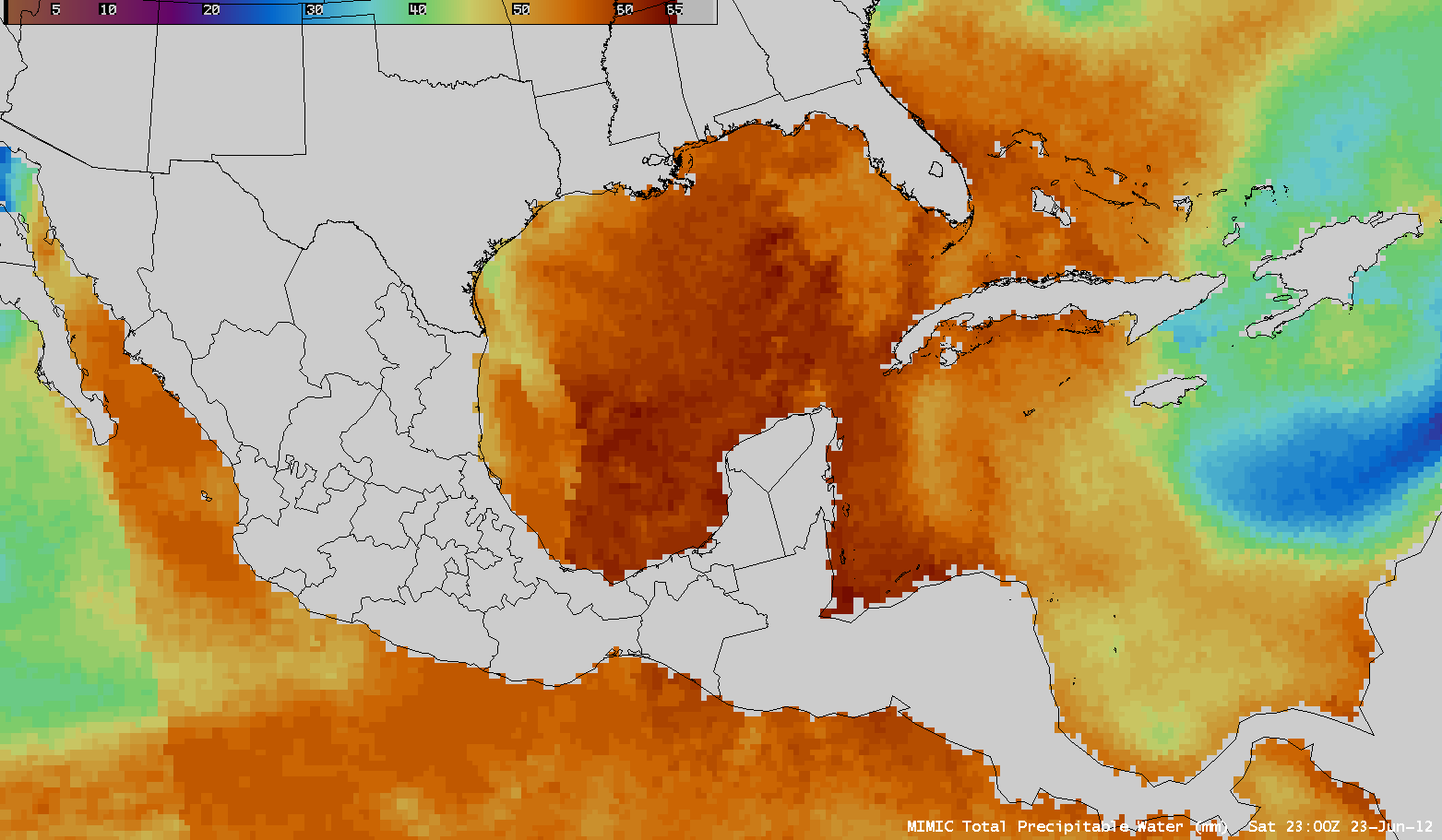
Microwave estimates of total precipitable water (from the CIMSS MIMIC website), above, from 24-27 July 2011, show the progression of a tropical wave through the northwest Caribbean Sea into the southern Gulf of Mexico. Late in the day on 27 July, Air Force Reconaissance found a closed circulation with winds that were... Read More

MIMIC TPW

MIMIC TPW

Microwave estimates of total precipitable water (from the CIMSS MIMIC website), above, from 24-27 July 2011, show the progression of a tropical wave through the northwest Caribbean Sea into the southern Gulf of Mexico. Late in the day on 27 July, Air Force Reconaissance found a closed circulation with winds that were strong enough to earn the system a tropical storm designation.

GOES 15 Visible Image 2245 UTC 27 July

GOES 15 Visible Image 2245 UTC 27 July

Visible imagery from late in the day (above) on the 27th shows extensive convection, with some overshooting tops over the Yucatan Channel and over the adjacent landmass. Forecasts are for Don to strengthen slowly as it moves towards the west-northwest. Oceanic heat content estimates from RSMAS as displayed at the CIMSS Tropical Weather website show a region of high heat content (associated with the Loop Current in the Gulf of Mexico) north of the projected path of Don. Intensification of Don could be more rapid if the storm moves farther to the north, over the region of higher heat content.

Shear values around Don are low. That and the warm sea surface temperatures over the Gulf argue for slow intensification.

Don’s projected path into south Texas takes it to a region suffering from extreme drought, as shown here.

View only this post Read Less
GOES-15 is out of storage

The earth-viewing instruments on the GOES-15 spacecraft, which is above 90 W longitude, were turned on July 25th, and will be sending Imager and Sounder data for the next two weeks. Satellites in storage are periodically awakened to test functionality. GOES-West, currently GOES-11, will be retired at the end of... Read More

GOES 15/GOES 13 Sounder loop

GOES 15/GOES 13 Sounder loop

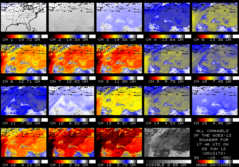
The earth-viewing instruments on the GOES-15 spacecraft, which is above 90 W longitude, were turned on July 25th, and will be sending Imager and Sounder data for the next two weeks. Satellites in storage are periodically awakened to test functionality. GOES-West, currently GOES-11, will be retired at the end of the year and GOES-15 is a candidate to replace that Geostationary Satellite at 135 W Longitude.

The above loop shows Sounder data from GOES-15 and GOES-13, both remapped to the same projection, for 1746 UTC on July 27th. Note that the most bands of the Sounder imagery from GOES-15 shows cleaner signals; colder detectors onboard GOES-15 (because GOES-15 has a different configuration than GOES-13) mean that the same signal has less noise.

Visible imagery from GOES-15 and GOES-13 gives similar views of the developing tropical system off the coast of Yucatan, in part because the satellites are only separated by 15 degrees of longitude (GOES-13 sits on the Equator at 75 degrees West Longitude)

GOES-15 imager data differs from GOES-11. Whereas GOES-11 has a 12.0 micrometer channel, which is useful for observations of dust and ash (when used in conjunction with the 10.7 micrometer channel), GOES-15 has a 13.3 micron channel, which data are useful for cloud-top properties.

GOES 15/GOES 13 Imager Water Vapor loop

GOES 15/GOES 13 Imager Water Vapor loop

The GOES-15 Imager water vapor channel has 4-km resolution versus 8-km resolution on GOES-11. In the loop above, note the better depiction of gradients (despite the vastly different view angles) and the better depiction of the mid-level vortex at the southwest edge of the image.

Another comparison of 8-km resolution GOES-11 6.7 µm water vapor images with corresponding 4-km resolution GOES-15 6.5 µm water vapor images can be seen below, viewing a lobe of middle-tropospheric vorticity that was moving southeastward over Nunavut, Canada (GOES water vapor image with an overlay of GFS 500 hPa vorticity). Again, the satellite viewing angles are different, but the features and gradients (even at the high latitude of 65 degrees North) are much clearer on the GOES-15 water vapor images.

GOES-11 6.7 µm (top panels) and GOES-15 6.5 µm water vapor channel images (bottom panels)

GOES-11 6.7 µm (top panels) and GOES-15 6.5 µm water vapor channel images (bottom panels)

View only this post Read Less
New AVHRR and MODIS cloud and fog products

Accurately diagnosing cloud properties can be a challenge, especially over regions such as the panhandle of southeastern Alaska where upstream upper air report information is sparse. New satellite products such as those derived using POES AVHRR and MODIS spectral bands (channels) can be helpful in such situations. On 22 July... Read More

POES AVHRR visible image + surface analysis

POES AVHRR visible image + surface analysis

Accurately diagnosing cloud properties can be a challenge, especially over regions such as the panhandle of southeastern Alaska where upstream upper air report information is sparse. New satellite products such as those derived using POES AVHRR and MODIS spectral bands (channels) can be helpful in such situations. On 22 July 2011, the Area Forecast Discussion issued by the National Weather Service forecast office at Juneau, Alaska included the following:

SOUTHEAST ALASKA FORECAST DISCUSSION
NATIONAL WEATHER SERVICE JUNEAU AK
529 AM AKDT FRI JUL 22 2011

.SHORT TERM…A LOW OVER THE SW GULF WILL MOVE TO THE S-CNTRL GULF BY LATE AFTERNOON…THEN BEGIN TO TURN SE TONIGHT. ASSOCIATED OCCLUDED FRONT WILL MOVE INTO THE SERN GULF BY LATE THIS AFTERNOON…THEN SLOWLY WEAKEN AS IT NEARS THE SRN OUTER COAST TONIGHT. USED A BLEND OF THE 00Z GFS AND ECMWF FOR THE SHORT TERM PERIOD.

OTHERWISE CLOUDS WILL BE A TRICKY CALL AS THERE WILL LIKELY BE SEVERAL AREAS OF THIN MID-LEVEL CLOUDS ALONG WITH SOME LOWER CLOUDS ALONG THE COAST AND WRN PARTS OF INNER CHANNELS. THINK A LOT OF THE LOWER CLOUDS WILL BREAK UP TODAY AS FLOW TURNS MORE ELY AHEAD OF APPROACHING FRONT. THE MID-LEVEL BANDS WILL BE A TRICKIER ISSUE…AND THINK A BAND WILL HANG ALONG THE COAST MTNS FROM THE PAJN AREA SEWD…BUT BE THIN AND BROKEN ENOUGH TO ALLOW SUNSHINE TO PEEK THROUGH MUCH OF THE TIME.

AWIPS images of the 1-km resolution POES AVHRR visible channel (above) and corresponding 1-km resoltion POES AVHRR IR channel (below) showed the cloud band associated with the occluded front as it approached the Alaska Panhandle.

POES AVHR IR image + surface analysis

POES AVHR IR image + surface analysis

A comparison of the 1-km resolution POES AVHRR Cloud Type, Cloud Top Temperature, and Cloud Height products (below) offered a bit more information about the composition and properties of various parts of this cloud band. The coldest cloud top temperature value within the cloud band was -54ºC, and the highest cloud top heights were 11 km.

POES AVHRR Cloud Type, Cloud Top Temperature, and Cloud Height products

POES AVHRR Cloud Type, Cloud Top Temperature, and Cloud Height products

Taking a closer look at the far southern Alaska Panhandle region using a comparison of the 1-km resolution MODIS Fog Depth, MODIS MVFR Probability, and MODIS IFR Probability products (below) indicated a number of localized ares where the fog depth was higher, and higher probabilities of Marginal Visual Flight Rules (MVFR) and Instrument Flight Rules (IFR) conditions existed.

MODIS Fog Depth, MVFR Probability, and IFR Probability products

MODIS Fog Depth, MVFR Probability, and IFR Probability products

CIMSS participation in GOES-R Proving Ground activities includes the development and testing of these types of products, along with their dissemination to select NWS offices for evaluation and feedback.

View only this post Read Less