")
GOES-15 and GOES-13 6.5 µm water vapor images (click image to play animation)
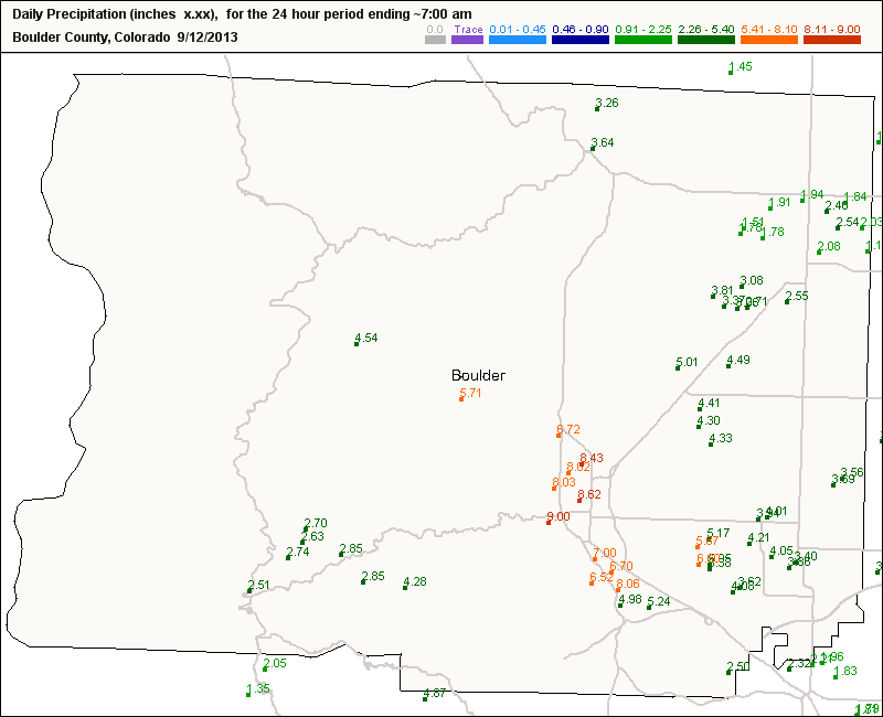
Heavy rain fell over much of the Front Range of Colorado overnight, with Boulder receiving an all-time 24-hour total of 9.08 inches (Weather Underground blog). Numerous CoCoRAHS locations in Boulder County reported 24-hour rainfall amounts in excess of 6″, in a region where monthly precipitation records are close to 6″. This event could be classified as a 500- to 1000-year event (as shown at NOAA’s Precipitation Data Frequency Server).
A composite of GOES-15 and GOES-13 6.5 µm water vapor imagery (above) showed the large-scale environment that supported heavy rains over Colorado. A quasi-stationary upper-level cyclonic circulation was over the western United States; that circulation was drawing moisture northward from off the Pacific coast of Mexico (some of this moisture may have been associated with tropical cyclone Lorena, which dissipated off Baja California last week). In addition, a lower-tropospheric anticyclonic circulation pushing into the Midwest was shunting moisture westward towards the Front Range (03 UTC surface analysis). Several circulations, therefore, were helping to move moisture-rich air towards eastern Colorado.

Percent of Normal Total Precipitable Water
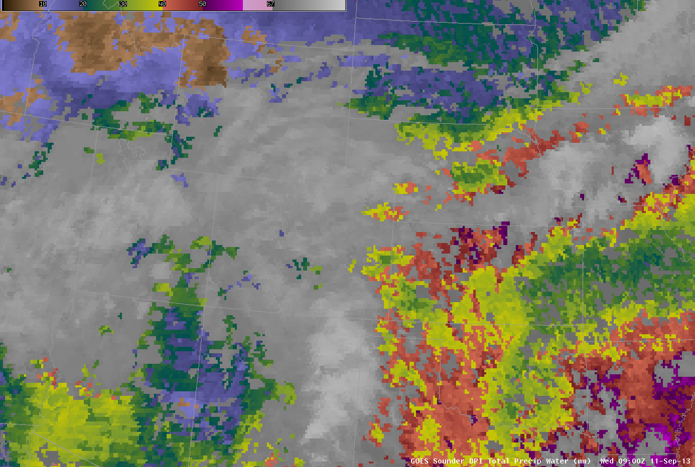
Moisture content of the air can be defined by total precipitable water (TPW). For example, the percent of normal as determined from the blended TPW product, above, showed a thin ribbon of values approaching 200% of normal banked up against the Front Range. An animation of GOES Sounder Derived Product Imagery (DPI) TPW (here) showed values (in between small breaks in the persistent cloudiness) exceeding 30 mm or 1.2 inches — in fact, the 1.33 inches of TPW derived from the 12 UTC Denver rawinsonde data set a new record for the month of September at that site (Weather Underground blog). The sounder data also demonstrates how the Front Range capably prevented moisture from moving from eastern to western Colorado: TPW values are smaller over central and western Colorado.
")
GOES-15 and GOES-13 10.7 µm IR images (click image to play animation)
GOES-15 (GOES-West) and GOES-13 (GOES-East) Imager 10.7 µm IR channel data, above, show that the convection that produced the flooding rains was relatively unimpressive on satellite imagery: cloud tops were not particularly cold. This suggests that warm-cloud processes were very efficient in producing the extraordinary rains in this event.One notable convective burst was seen to develop over the Boulder area (station identifier KBJC) after about 03 UTC on 12 September (10 PM local time on 11 September).
 images at ~0440 UTC")
MODIS and GOES-13 Longwave IR (~10.7 µm) images at ~0440 UTC
 images at ~0900 UTC")
MODIS and GOES-13 Longwave IR (~10.7 µm) images at ~0900 UTC
The relatively small-scale nature of this event suggests that high-resolution polar-orbiter data might be useful in describing the environment surrounding the storms. MODIS, for example, provided high-resolution imagery twice overnight, and comparisons between the MODIS and concomitant GOES imagery is shown above. MODIS data does have somewhat cooler cloud-top IR brightness temperatures (-54 to -55 C on MODIS, vs -48 to -50 C on GOES). The strongest convection is over the region that reported very heavy rains. Note that the MODIS imagery does not suffer from the parallax shift inherent in GOES imagery.

Suomi/NPP VIIRS Day/Night Band imagery at 0826 UTC
Suomi/NPP VIIRS data was also available over Colorado during the overnight hours. The Day/Night Band imagery at 0826 UTC or 2:26 AM local time, above, showed a region of clouds over the Front Range of Colorado (city lights nevertheless do shine through the clouds). There is little indication of widespread intense lightning (characterized in Day/Night Band imagery as a smear of light along a scan line) — in fact, only a single negative cloud-to-ground strike was seen in the Denver area at that time.
Heavy rains over the Front Range of Colorado are typically accompanied by easterly (upslope) flow. The image below shows METAR data plotted over the Suomi/NPP VIIRS 11.45 µm IR data. Easterly flow is common at many of the reporting sites.

Suomi/NPP VIIRS 11.45 µm IR imagery at 0826 UTC
Two 12-day animations from GOES-13 (immediately below) and GOES-15 (below GOES-13) show the large-scale environment before, during and after the heavy rains.
")
GOES-13 6.5 µm water vapor images, 5-16 September 2013 (click image to play animation)
")
GOES-15 6.5 µm water vapor images, 5-16 September 2013 (click image to play animation)

Weekly Precipitation ending 16 September 2013
Weekly storm totals from this event (from this NOAA site) show widespread heavy rains over both Colorado and New Mexico. A large area exceeded 600% of normal for the week!
View only this post Read Less

")
")
 - click image to play animation")
")
")
")
")
")
")
