This website works best with a newer web browser such as Chrome, Firefox, Safari or Microsoft Edge. Internet Explorer is not supported by this website.

Diagnosing areas of light winds over water

An AWIPS image of 1-km resolution Suomi NPP VIIRS 0.64 µm visible channel data (above) revealed a large patch of water within the eastern Gulf of Mexico “sun glint” region that exhibited a much darker appearance than the surrounding waters off the west coast of Florida on Read More

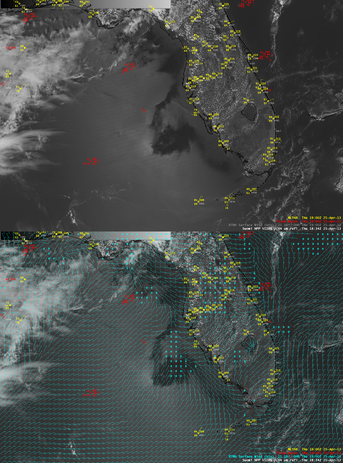
Suomi NPP VIIRS 0.65 µm visible channel image with overlays of surface reports and RTMA surface winds

Suomi NPP VIIRS 0.65 µm visible channel image with overlays of surface reports and RTMA surface winds

An AWIPS image of 1-km resolution Suomi NPP VIIRS 0.64 µm visible channel data (above) revealed a large patch of water within the eastern Gulf of Mexico “sun glint” region that exhibited a much darker appearance than the surrounding waters off the west coast of Florida on 25 April 2013. This patch of darker water generally corresponded to a region of very light to calm winds, as verified by an overlay of the Real-Time Mesoscale Analysis (RTMA) surface winds. As explained in a previous blog post, there is often a significant amount of sun glint off the wind-driven rough water surfaces below a polar-orbiting satellite overpass — due to scattering of light these areas of sun glint make the rougher water surfaces appear brighter on visible imagery. However, in an area of calm winds, the water surface becomes very flat; this flat water surface then reflects incoming sunlight like a mirror (with all the light being reflected back in one direction — but in this case, that one direction was not directly back toward the satellite).

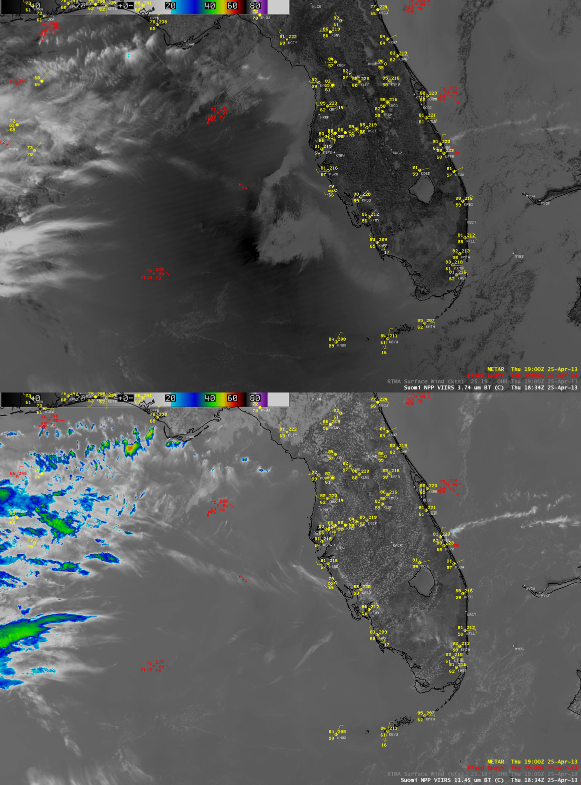
Another interesting signature of the flat water surface is seen in a comparison of 1-km resolution Suomi NPP VIIRS 3.74 µm shortwave IR channel and 11.45 µm longwave IR or “IR window” channel images (below). The shortwave IR channel is very sensitive to reflected solar radiation, and will often exhibit a much warmer, darker signal over areas of sun glint. However, note that the areas of darker water seen in the visible image above appear significantly cooler (lighter gray enhancement) on the shortwave IR image. Again, in the case of smooth, flat water in light wind regions, the incoming solar radiation is reflected back in a direction that happens to be away from the satellite sensors. Since the 11.45 µm IR channel is not sensitive to reflected solar radiation, no such signature was seen in that particular image.

Suomi NPP VIIRS 3.74 µm shortwave IR channel and 11.45 µm longwave IR or

Suomi NPP VIIRS 3.74 µm shortwave IR channel and 11.45 µm longwave IR or “IR window” channel images

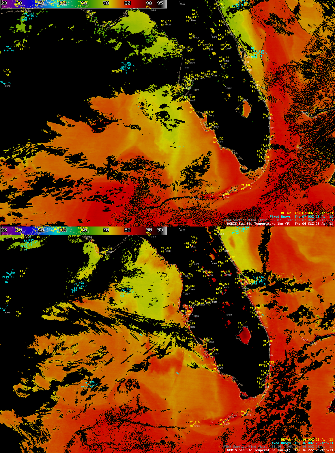
A nighttime vs daytime comparison of the 1-km resolution MODIS Sea Surface Temperature (SST) product (below) showed that the SST values over the patch of calm water increased from the low to middle 70s F at 06:58 UTC (2:58 AM local time) to the upper 70s to 80º F at 16:22 UTC (12:22 PM local time). Such an increase in SST within a relatively short 10-hour period was possible due to the fact that the presence of very light winds also allowed the skin temperature of the water surface to warm very quickly (as we have previously seen over Lake Michigan).

MODIS Sea Surface Temperature product

MODIS Sea Surface Temperature product

View only this post Read Less
Hail-producing thunderstorm at Kandahar, Afghanistan

A thunderstorm produced golf-ball-size hail that reportedly lasted up to 30 minutes at Kandahar, Afghanistan on 23 April 2013. This hail was responsible for 3 fatalities, and damaged dozens of US and British military helicopters and aircraft stationed at Kandahar International Airport. McIDAS images of EUMETSAT Meteosat-7 0.7 µm visible... Read More

EUMETSAT Meteosat-7 0.7 µm visible channel images (click image to play animation)

EUMETSAT Meteosat-7 0.7 µm visible channel images (click image to play animation)

A thunderstorm produced golf-ball-size hail that reportedly lasted up to 30 minutes at Kandahar, Afghanistan on 23 April 2013. This hail was responsible for 3 fatalities, and damaged dozens of US and British military helicopters and aircraft stationed at Kandahar International Airport. McIDAS images of EUMETSAT Meteosat-7 0.7 µm visible channel images (above; click image to play animation) and 11.5 µm IR channel images (below; click image to play animation) showed the rapid development of the relatively compact thunderstorm as it passed over Kandahar International Airport (denoted by the “*” symbol). Shadow-casting overshooting tops were evident on the visible imagery, and the cloud-top IR brightness temperature cooled to -66 C (dark red color enhancement) at 08:30 UTC.

EUMETSAT Meteosat-7 11.5 µm IR channel images (click image to play animation)

EUMETSAT Meteosat-7 11.5 µm IR channel images (click image to play animation)

View only this post Read Less
“Southerly surge” of stratus along the coast of California

McIDAS images of GOES-15 0.63 µm visible channel data (above; click image to play animation) revealed a well-defined “southerly surge” of stratus clouds, which were moving northward along the coast of the Big Sur region of central California on 22 April 2013.AWIPS images... Read More

GOES-15 0.63 µm visible channel images (click image to play animation)

GOES-15 0.63 µm visible channel images (click image to play animation)

McIDAS images of GOES-15 0.63 µm visible channel data (above; click image to play animation) revealed a well-defined “southerly surge” of stratus clouds, which were moving northward along the coast of the Big Sur region of central California on 22 April 2013.

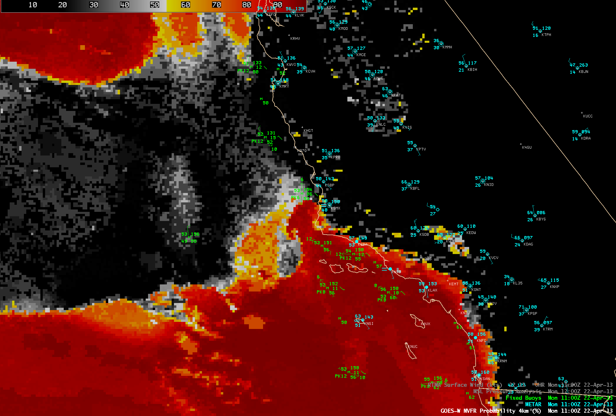
AWIPS images of the GOES-R Marginal Visual Flight Rules (MVFR) product algorithm applied to GOES-15 data (below; click image to play animation) showed the northward progression of the narrow band of stratus clouds, as a mesoscale reversal in the boundary layer winds just off the coast (from northerly, to southerly) was seen in the buoy data.

GOES-15 Marginal Visual Flight Rules (MVFR) Probability product (click image to play animation)

GOES-15 Marginal Visual Flight Rules (MVFR) Probability product (click image to play animation)

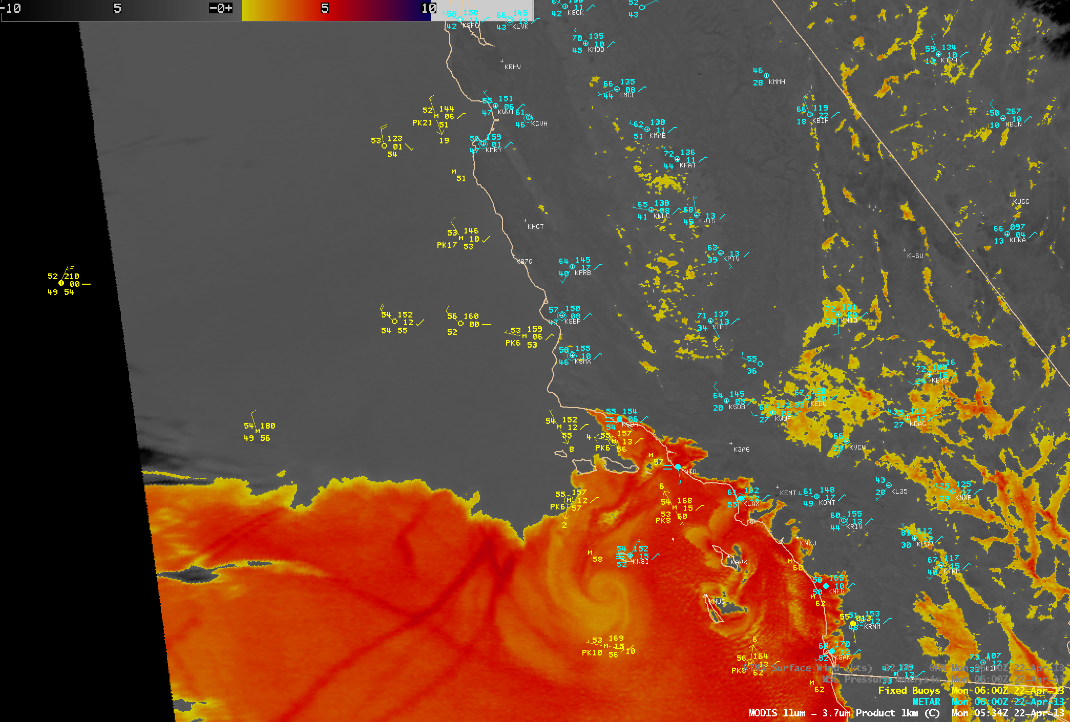
A 1-km resolution MODIS 11-3.7 µm IR brightness temperature difference (BTD) “fog/stratus product” image at 05:34 UTC or 10:34 PM local time (below) showed the initial stages of the southerly surge stratus cloud feature, in the Santa Barbara Channel north of the Channel Islands off the coast of southern California (and south of Point Conception). Farther offshore, the BTD image also displayed a well-defined eddy and a few ship tracks embedded within the marine boundary layer stratus clouds.

MODIS IR brightness temperature difference

MODIS IR brightness temperature difference “fog/stratus product”

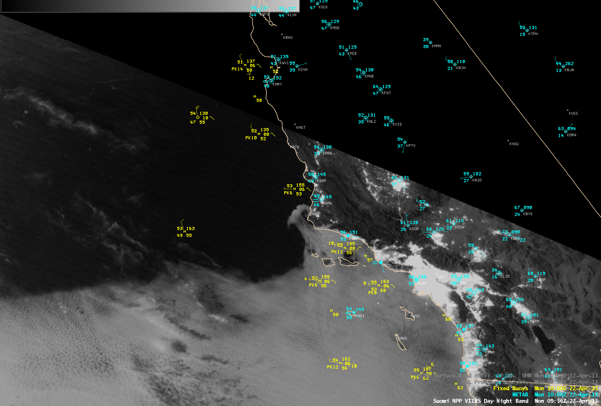
Several hours later, a 1-km resolution Suomi NPP VIIRS 0.7 µm Day/Night Band (DNB) image at 09:56 UTC or 2:26 AM local time (below) indicated that the leading edge of the southerly surge stratus cloud feature had moved to the north of Point Conception. This demonstrates that the VIIRS DNB can provide a “visible image at night”, given sufficient illumination by the Moon (or other light sources). On this night the Moon was in the waxing gibbous phase, at 95% full.

Suomi NPP VIIRS 0.7 µm Day/Night Band image

Suomi NPP VIIRS 0.7 µm Day/Night Band image

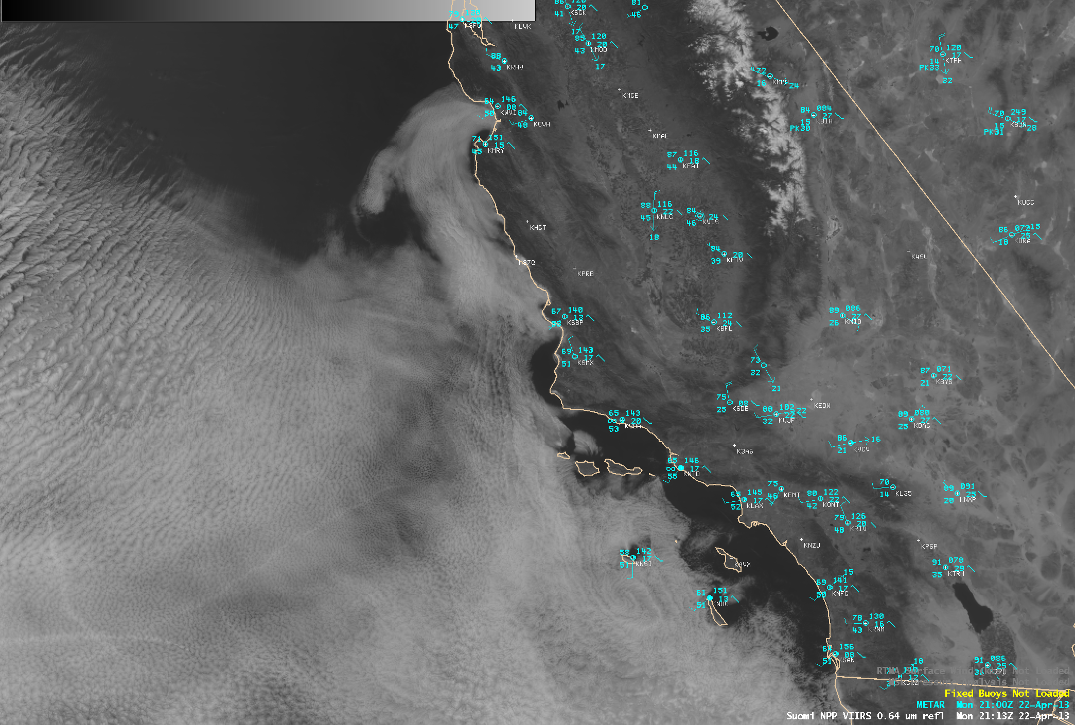
A Suomi NPP VIIRS 0.64 µm visible channel image at 21:13 UTC or 2:13 PM local time (below) showed leading edge of the southward surge stratus feature as it was curving eastward into the Monterey Bay area. Not far to the north, San Francisco reached a record high temperature of 83º F.

Suomi NPP VIIRS 0.64 µm visible channel image

Suomi NPP VIIRS 0.64 µm visible channel image

===== 23 April Update =====

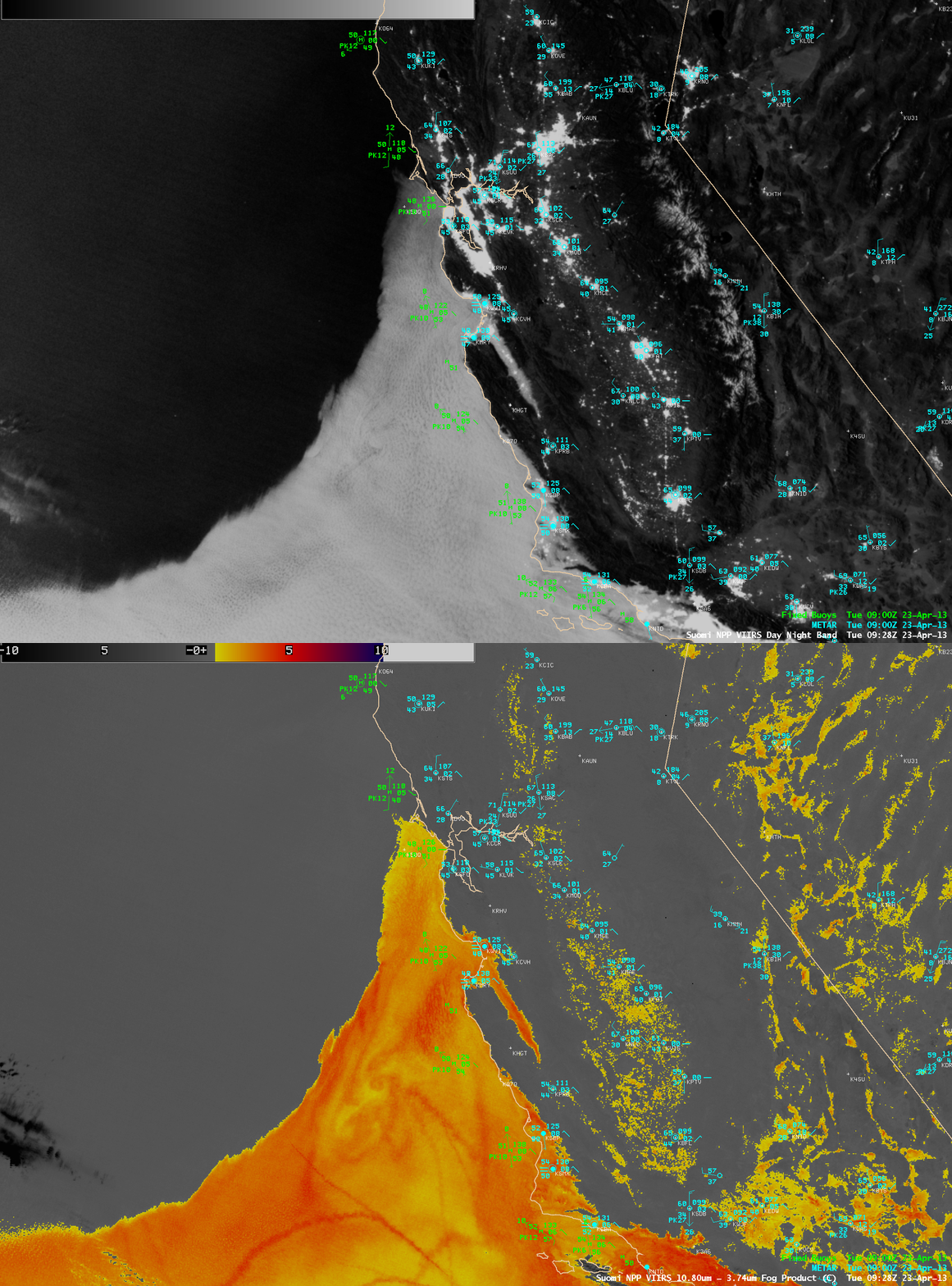
A comparison of 1-km resolution Suomi NPP VIIRS 0.7 µm Day/Night Band and IR brightness temperature difference (BTD) “Fog/stratus product” images at 09:28 UTC or 2:29 AM local time (below) showed that the leading edge of the southerly surge stratus clouds had progressed just to the north of Point Reyes. Once again, the BTD image revealed the presence of cloud eddies and ship tracks within the marine boundary layer stratus clouds.

Suomi NPP VIIRS 0.7 µm Day/Night Band and IR brightness temperature difference

Suomi NPP VIIRS 0.7 µm Day/Night Band and IR brightness temperature difference “Fog/stratus product” images


View only this post Read Less
Earth Day 2013

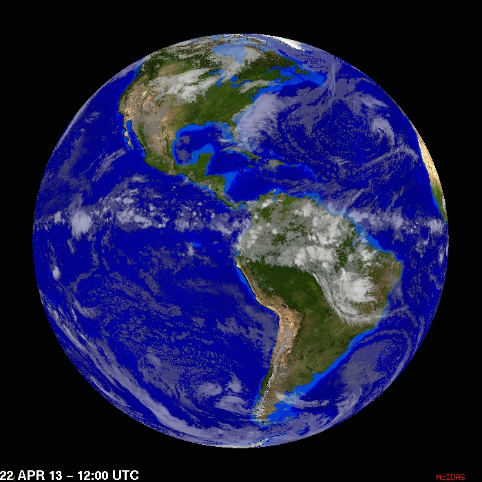
In honor of Earth Day, we offer a glimpse of the cloud cover across the planet, using a rotating global composite of geostationary IR images (data from the GOES-East, GOES-West, Meteosat, and MTSAT satellites) at 12:00 UTC on 22 April 2013 (above; click image to play animation).... Read More

Global composite of geostationary IR images at 12:00 UTC (click image to play animation)

Global composite of geostationary IR images at 12:00 UTC (click image to play animation)

In honor of Earth Day, we offer a glimpse of the cloud cover across the planet, using a rotating global composite of geostationary IR images (data from the GOES-East, GOES-West, Meteosat, and MTSAT satellites) at 12:00 UTC on 22 April 2013 (above; click image to play animation). The most recent rotating global IR composite (updated every 3 hours) can be seen here.

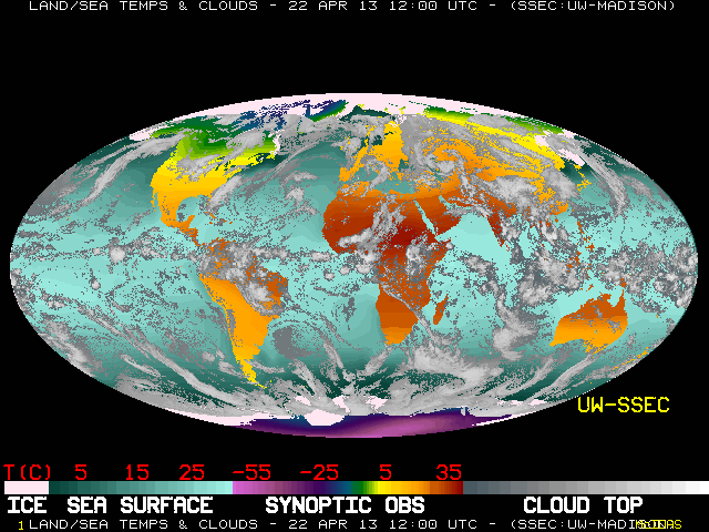
lobal composite of IR imagery, land surface temperature, and sea surface temperature (click image for most recent animation)

Global composite of IR imagery, land surface temperature, and sea surface temperature (click image for most recent animation)

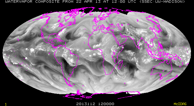
Other global satellite image composites created at SSEC include IR, surface air temperature, and sea surface temperature (above; click image for most recent animation) and water vapor channel  imagery (below; click image for most recent animation).

Global composite of water vapor imagery (click image for most recent animation)

Global composite of water vapor imagery (click image for most recent animation)

View only this post Read Less