This website works best with a newer web browser such as Chrome, Firefox, Safari or Microsoft Edge. Internet Explorer is not supported by this website.

Strong July storm “Zeljko” affects parts of central Europe

EUMETSAT Meteosat-10 6.25 µm water vapor channel images (above; click image to play animation; also available as an MP4 movie file) showed the well-defined circulation associated with an unusually strong (for July) storm centered just north of the Netherlands on 25 July 2015. Some locations experienced hurricane-force surface winds with this storm... Read More

Meteosat-10 6.25  µm water vapor channel images [click to play animation]

Meteosat-10 6.25 µm water vapor channel images [click to play animation]

EUMETSAT Meteosat-10 6.25 µm water vapor channel images (above; click image to play animation; also available as an MP4 movie file) showed the well-defined circulation associated with an unusually strong (for July) storm centered just north of the Netherlands on 25 July 2015. Some locations experienced hurricane-force surface winds with this storm — which was given the name “Zeljko” by the Free University of Berlin (surface analyses) — and it was described as the most violent July storm on record for the Netherlands, where a wind gust of 121 km/hour (65 knots, or 75 mph) was reported. Peak wind gusts at major airports are plotted on the water vapor imagery above, which showed 55 knots or 63 mph at Amsterdam in the Netherlands at 13 UTC, and 47 knots or 54 mph at Münster-Osnabrück in northern Germany at 17 UTC. Strong winds disrupted both rail and air traffic in some areas; the winds made for some challenging landings at the Amsterdam Schiphol airport (one of which was documented in this YouTube video).

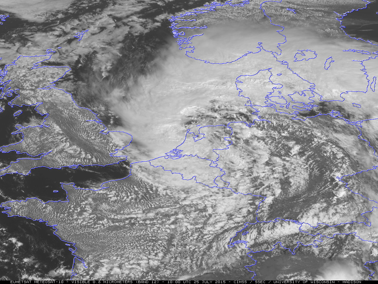
Meteosat-10 0.8 µm High Resolution Visible images (below; click image to play animation; also available as an MP4 movie file) displayed better detail of the center of the storm circulation when it was immediate off the coast of the Netherlands during the middle of the day.

Meteosat-10 0.8 µm visible channel images [click to play animation]

Meteosat-10 0.8 µm visible channel images [click to play animation]

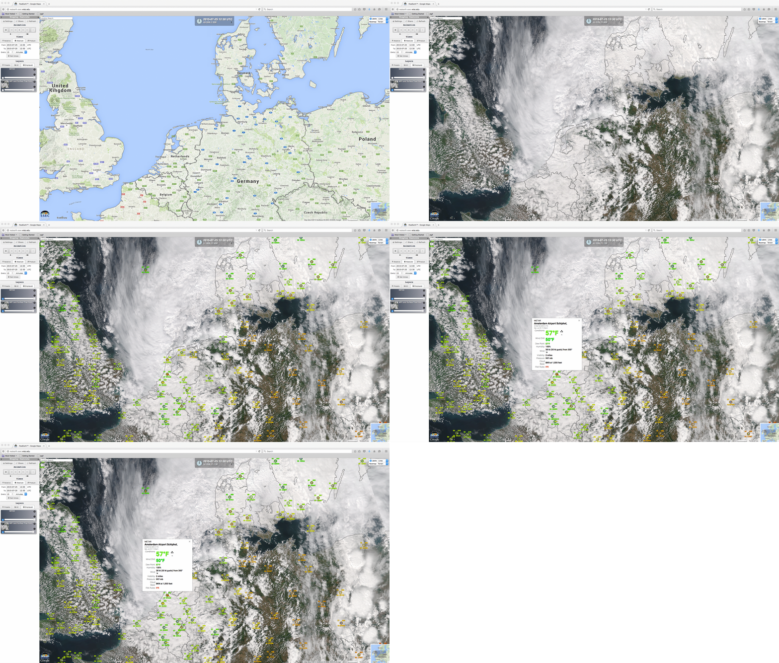
A Suomi NPP VIIRS true-color Red/Green/Blue (RGB) image visualized using the SSEC RealEarth web map server (below)  showed the center of the strong mid-latitude cyclone just off the coast of the Netherlands; at the time, winds were gusting to 50 knots at the Amsterdam Schiphol airport.

Suomi NPP VIIRS true-color image, with METAR surface reports

Suomi NPP VIIRS true-color image, with METAR surface reports

View only this post Read Less

Reynolds Creek Fire in Glacier National Park, Montana

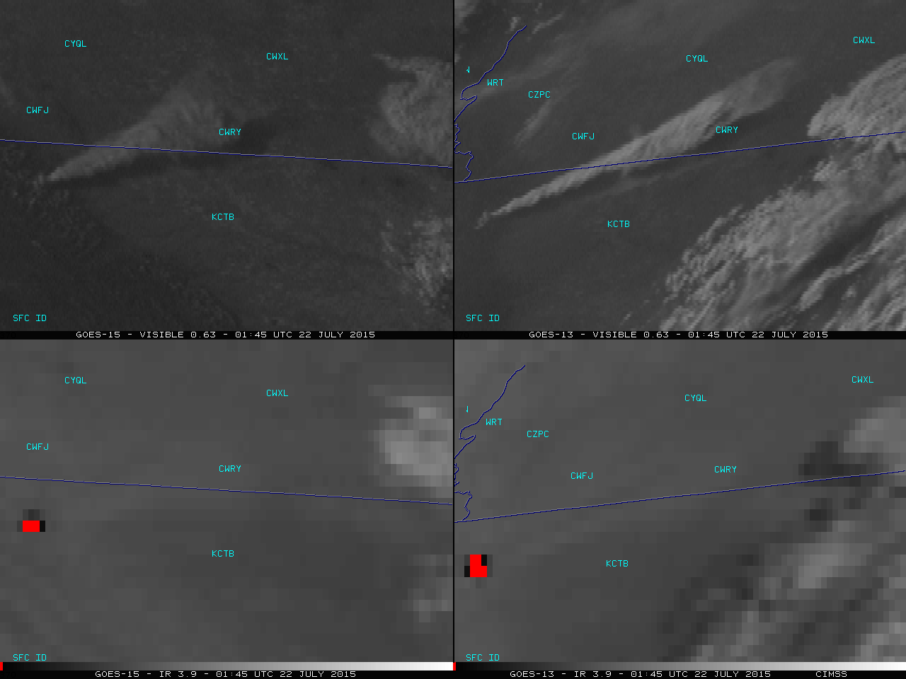
Shown above (click image to play animation; also available as an MP4 movie file) is a 4-panel comparison of GOES-15 (GOES-West, left panels) and GOES-13 (GOES-East, right panels) 0.63 µm visible channel images (top) and 3.9 µm shortwave IR images (bottom) which showed the development of the the long smoke plume and... Read More

GOES-15 (left) and GOES-13 (right) visible and shorwave IR images [click to play animation]

GOES-15 (left) and GOES-13 (right) visible and shorwave IR images [click to play animation]

Shown above (click image to play animation; also available as an MP4 movie file) is a 4-panel comparison of GOES-15 (GOES-West, left panels) and GOES-13 (GOES-East, right panels) 0.63 µm visible channel images (top) and 3.9 µm shortwave IR images (bottom) which showed the development of the the long smoke plume and the fire hot spot (dark black to red shortwave IR pixels)  associated with the Reynolds Creek Fire (InciWeb | Wildfire Today) which began to burn in the eastern portion of the Glacier National Park in Montana around 2145 UTC or 3:43 pm local time on 21 July 2015. A Red Flag Warning was in effect for the region, due to the combination of warm temperature with low relative humidity, and strong southwesterly winds (gusting to 30 mph at Cut Bank and 29 mph at Browning).

Another sequence of GOES-15 visible channel images is shown below (click image to play animation; also available as a MP4 movie file). Another smaller smoke plume can be seen originating from a fire in far southeastern British Columbia.

GOES-15 visible channel images [click to play animation]

GOES-15 visible channel images [click to play animation]

As it continued to burn into the following night; a comparison of Suomi NPP VIIRS 3.74 µm shortwave IR and 0.8 µm Day/Night Band images at 0958 UTC or 3:58 am local time (below) revealed the hot spot (yellow to red to black pixels) and the bright glow of the fire.

Suomi NPP VIIRS shortwave IR and Day/Night Band images [click to enlarge]

Suomi NPP VIIRS shortwave IR and Day/Night Band images [click to enlarge]

—————————————————————————

Suomi NPP VIIRS 3.74 µm shortwave IR images [click to enlarge]

Suomi NPP VIIRS 3.74 µm shortwave IR images [click to enlarge]

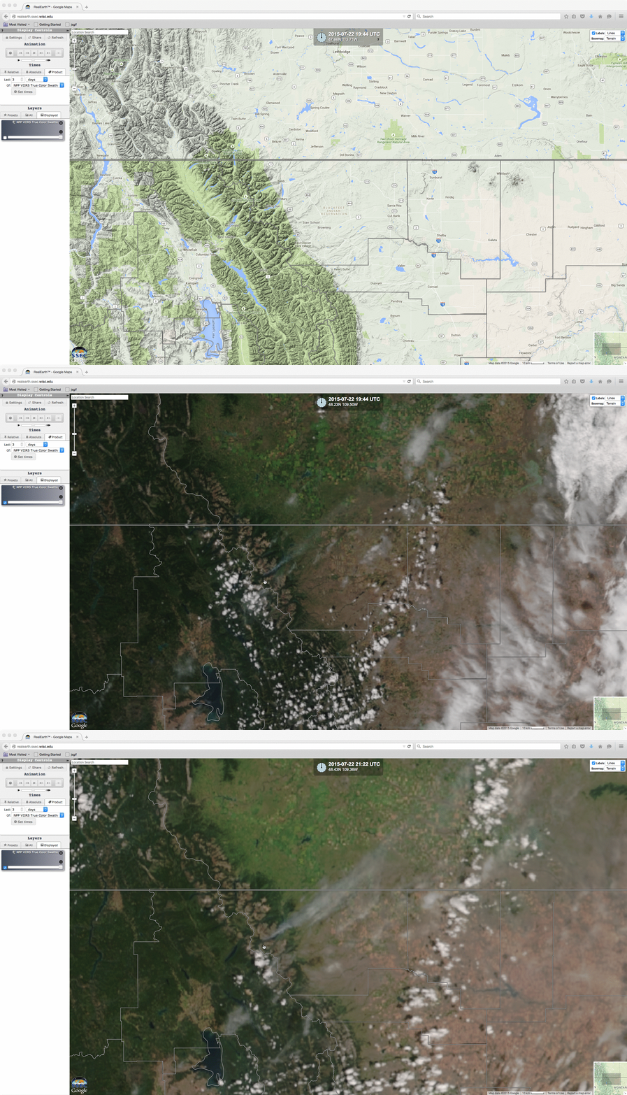
On the following day (22 July), consecutive afternoon (1944 and 2122 UTC) Suomi NPP VIIRS 3.74 µm shortwave IR channel images (above) revealed changes in the shape and areal coverage of the fire hot spot (dark black pixels); the corresponding VIIRS Red/Green/Blue (RGB) true-color images (below) still showed a smoke plume, though is was not as large as that seen on the GOES visible imagery from the previous day.

Suomi NPP VIIRS true-color RGB images

Suomi NPP VIIRS true-color RGB images

—————————————————————————

On 23 July, daytime (1925 and 2104 UTC) Suomi NPP VIIRS 3.74 µm shortwave IR and true-color RGB images (below) continued to display large fire hot spots and a smoke plume drifting toward the east-northeast. The size of the Reynolds Creek Fire was estimated to have increased to 4000 acres.

Suomi NPP VIIRS 3.74 µm shortwave IR and true-color RGB images [click to enlarge]

Suomi NPP VIIRS 3.74 µm shortwave IR and true-color RGB images [click to enlarge]

View only this post Read Less

Flooding Rains in southern California

Unusual rains causing flooding and mudslides hit southern California (San Diego in particular) on 18-19 July 2015. The two-day rain total (1.69″) at Lindbergh Field broke the monthly record for July (previous record, 1.29″) and exceeded the January-April 2015 rainfall (the typical wet season) at the station. The San Diego... Read More

GOES-15 Infrared Water Vapor (6.5 µm) Images  (click to play animation)

GOES-15 Infrared Water Vapor (6.5 µm) Images (click to play animation)

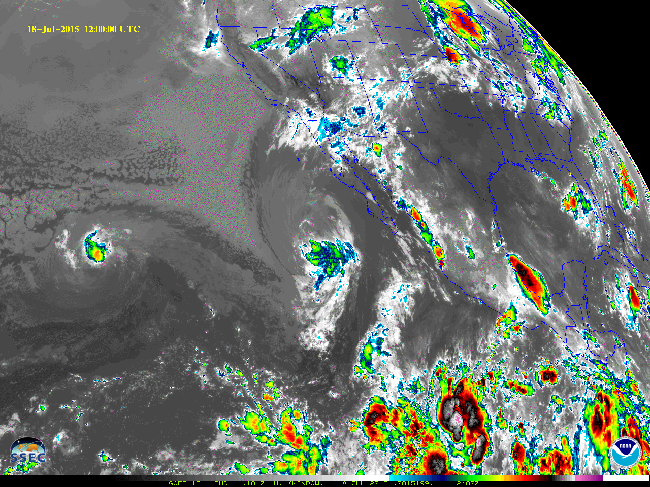
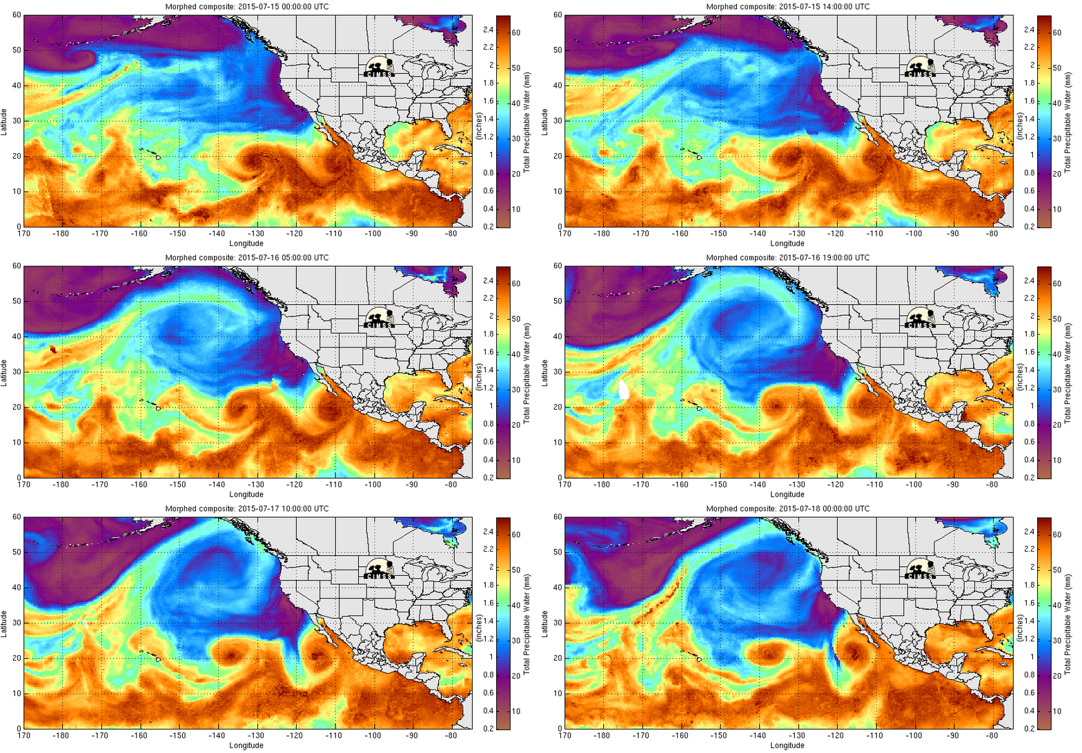
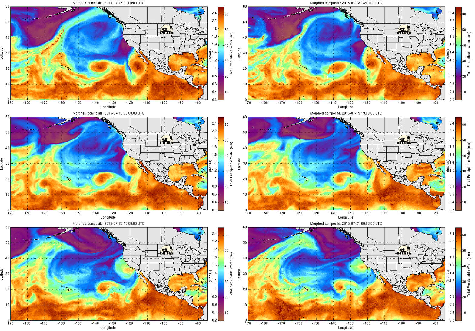
Unusual rains causing flooding and mudslides hit southern California (San Diego in particular) on 18-19 July 2015. The two-day rain total (1.69″) at Lindbergh Field broke the monthly record for July (previous record, 1.29″) and exceeded the January-April 2015 rainfall (the typical wet season) at the station. The San Diego Padres had their first July rainout ever, and the Anaheim Angels had their first rainout since 1995! What caused the rains? The water vapor imagery, above, shows the three systems that contributed. Pacific Hurricane Dolores (Track) was declared post-tropical off the coast of Baja California at 0300 UTC on 19 July. Farther to the west, Pacific Tropical Storm Enrique was declared post-tropical at 0300 on 18 July. High pressure aloft was helping support a Gulf Surge, a surge of moisture up the Gulf of California towards the desert southwest. Two animations of MIMIC Total Precipitable Water, below, show the surge and also show that moisture associated with main circulation of Dolores remains mostly offshore until late on the 19th, after the heavy rains had ended.

MIMIC Total Precipitable Water, 0000 UTC on 15 July through 0000 UTC on 18 July 2015 (click to enlarge)

MIMIC Total Precipitable Water, 0000 UTC on 15 July through 0000 UTC on 18 July 2015 (click to enlarge)

MIMIC Total Precipitable Water, 0000 UTC on 18 July through 0000 UTC on 21 July 2015  (click to enlarge)

MIMIC Total Precipitable Water, 0000 UTC on 18 July through 0000 UTC on 21 July 2015 (click to enlarge)

The Blended Precipitable Water Product (data collected from this site), below, also shows evidence of a Gulf Surge of moisture moving northward through the Gulf of California in the few days preceding the rains.

NESDIS Blended Total Precipitable Water (left) and Percent of Normal (right), 1200 UTC on 15 July through 1200 UTC on 20 July 2015 (click to animate)

NESDIS Blended Total Precipitable Water (left) and Percent of Normal (right), 1200 UTC on 15 July through 1200 UTC on 20 July 2015 (click to animate)

The animation of 10.7 µm imagery, below, suggests that the precipitation on Saturday the 18th was associated more with the Gulf Surge of moisture (which surge was likely influenced both by the large scale synoptic flow and by the circulation of Dolores); precipitation on Sunday the 19th seems more directly influenced by Dolores.

GOES-15 Infrared (10.7 µm) Images  (click to play animation)

GOES-15 Infrared (10.7 µm) Images (click to play animation)

What part did the upper-level outflow jets from the two tropical cyclones play in this event? Consider the water vapor animation below, zoomed in from the larger-scale view at the top of this post. Outflow from Enrique moves from the southwest part of the domain towards the southern California coast (the low-level circulation of Enrique are at the southwest edge of the domain), moving inland as convection develops on Saturday 18 July 2015. The Total Precipitable Water imagery suggests that convection starts as the leading edge of the Gulf Surge arrives; water vapor imagery suggests a tie to Enrique.

GOES-15 Infrared Water Vapor (6.5 µm) Images  (click to play animation)

GOES-15 Infrared Water Vapor (6.5 µm) Images (click to play animation)

GOES-15 Visible Imagery, below, from Saturday the 18th and from Saturday the 19th suggest rain on 19 July was more directly tied to the circulation of Dolores. On both days, the convective nature of the precipitation is apparent, with numerous overshooting tops present. Convection on Sunday the 19th started over higher terrain first, and then was joined by tropical convection moving in from the ocean.

GOES-15 Visible (0.65 µm) Images, 1300 UTC 18 July through 0300 UTC 19 July 2015  (click to play animation)

GOES-15 Visible (0.65 µm) Images (click to play animation)

GOES-15 Visible (0.65 µm) Images, 1300 UTC 19 July through 0300 UTC 20 July 2015  (click to play animation)

GOES-15 Visible (0.65 µm) Images (click to play animation)

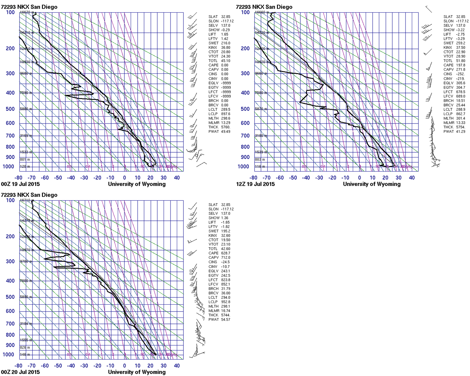
As might be expected, the San Diego sounding (source) shows deep tropical moisture late on the 18th and late on the 19th as the heavy rains occurred. The precipitable water value of 2.10″ at 0000 UTC on 20 July was a top 5 value for July (Source). The rains caused two spikes in the flow of the San Diego River (Link, courtesy Alex Tardy, NWS San Diego).

Stuve plots of radiosonde data at 72293, 0000 and 1200 UTC 19 July and 0000 UTC 20 July 2015  (click to enlarge)

Stuve plots of radiosonde data at 72293, 0000 and 1200 UTC 19 July and 0000 UTC 20 July 2015 (click to enlarge)

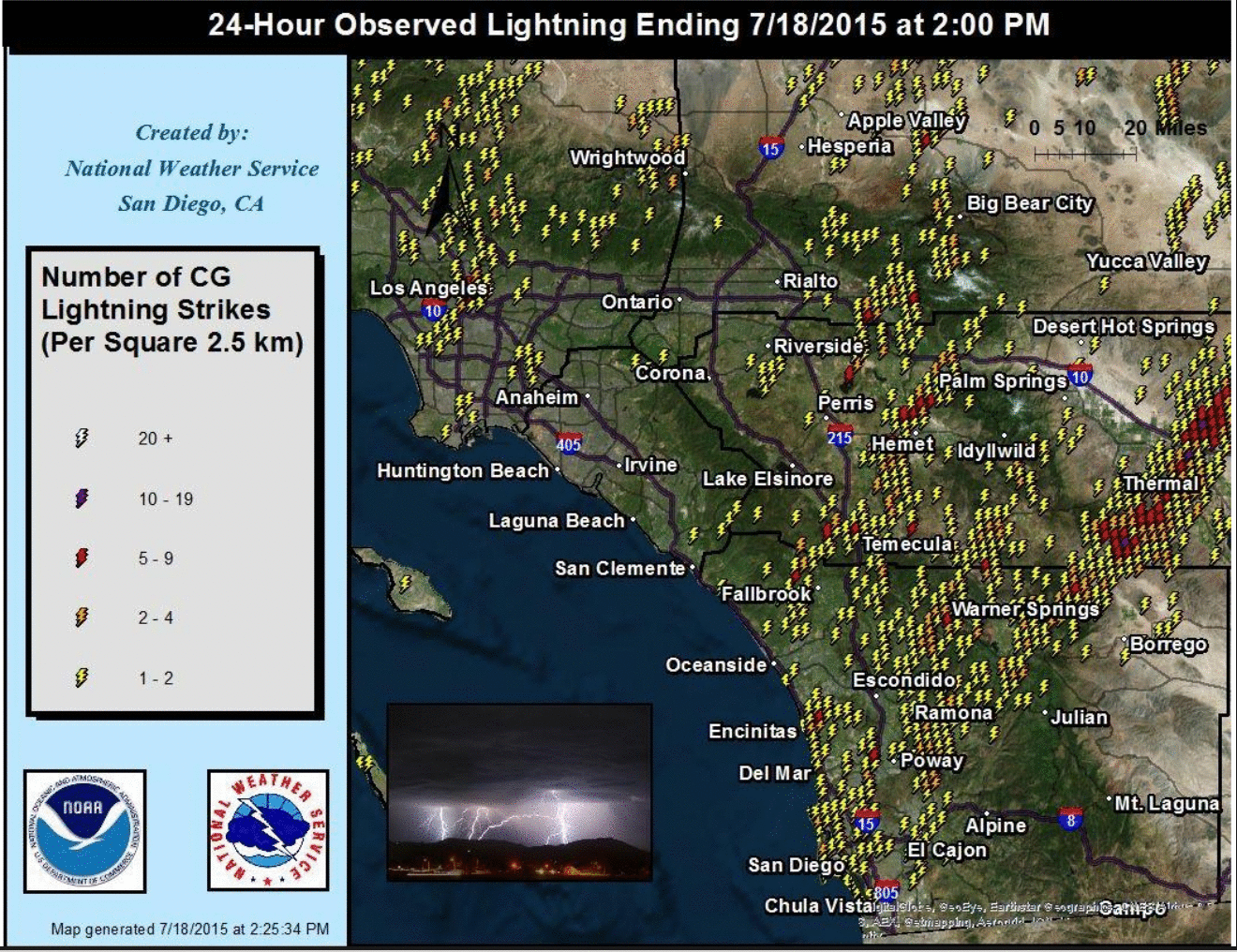
The convection over San Diego produced many lightning strikes on Saturday, as shown on the map below, courtesy of Alex Tardy, NWS San Diego.

Lightning Strikes for the 24 hours ending 2 PM PDT on Saturday 18 July 2015 (click to enlarge)

Lightning Strikes for the 24 hours ending 2 PM PDT on Saturday 18 July 2015 (click to enlarge)

View only this post Read Less

Wildfire smoke: from Alaska to Norway, via the Arctic and Atlantic Oceans

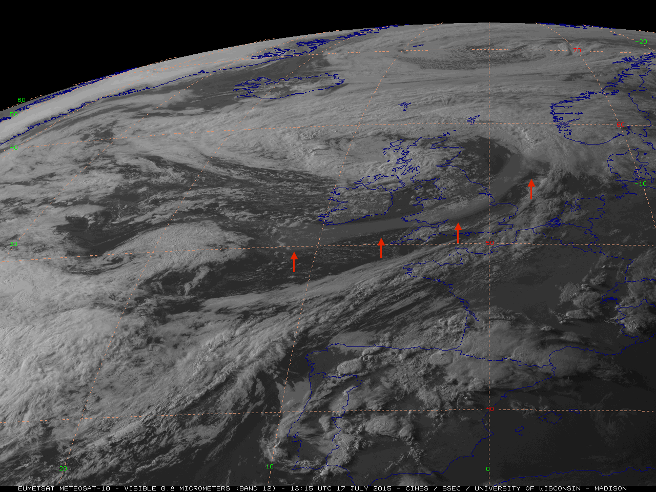
EUMETSAT Meteosat-10 High Resolution Visible (0.8 µm) images (above; click to play animation; also available as an MP4 movie file) revealed the hazy signature of what appeared to be a ribbon of smoke aloft being transported eastward across the North Atlantic Ocean by the circulation of a large area of low pressure... Read More

Meteosat-10 0.8 µm visible channel images [click to play animation]

Meteosat-10 0.8 µm visible channel images [click to play animation]

EUMETSAT Meteosat-10 High Resolution Visible (0.8 µm) images (above; click to play animation; also available as an MP4 movie file) revealed the hazy signature of what appeared to be a ribbon of smoke aloft being transported eastward across the North Atlantic Ocean by the circulation of a large area of low pressure (surface | 500 hPa) on 17 July 2015. Early in the day, the smoke feature stretched from the east coast of Greenland to the central Atlantic Ocean; by the end of the day, the leading edge of the smoke had moved over the British Isles and was headed toward Scandinavia.

A portion of the smoke plume could be seen on Aqua MODIS and Suomi NPP VIIRS true-color Red/Green/Blue (RGB) images (below) as it was approaching the southern portion of Great Britain.

Aqua MODIS and Suomi NPP VIIRS true-color images [click to enlarge]

Aqua MODIS and Suomi NPP VIIRS true-color images [click to enlarge]

On the following morning, Meteosat-10 visible images (below; click to play animation) showed that the leading edge of the smoke ribbon was moving over southern Norway.

Meteosat-10 0.8 µm visible channel images [click to play animation]

Meteosat-10 0.8 µm visible channel images [click to play animation]

The transport pathway of this smoke feature was rather interesting, as we shall explore with the following sets of images.

Suomi NPP VIIIRS 3.74 µm shortwave IR and 0.64 µm visible images on 06 July [click to enlarge]

Suomi NPP VIIIRS 3.74 µm shortwave IR and 0.64 µm visible images on 06 July [click to enlarge]

The 2015 wildfire season in Alaska had been very active — as of 17 July, it was rated as the 4th worst in terms of total acreage burned. In early July, numerous wildfires burning across the interior of Alaska were producing a large amount of smoke, as can be seen in a comparison of of Suomi NPP VIIRS 3.74 µm shortwave IR and 0.64 µm visible channel images at 2131 and 2312 UTC on 06 July (above). The thermal signature of the wildfire “hot spots” showed up as yellow to red to black pixels on the 2 shortwave IR images, while the widespread smoke plumes from the fires are evident on the 2 visible images; even in the relatively short 101 minutes separating the two sets of VIIRS images, notable changes in fire activity could be seen.

Looking a bit farther to the north and west, a sequence of VIIRS 0.64 µm visible images centered over Cape Lisburne (station identifier PALU) in northwestern Alaska covering a 2-day period from 06 to 08 July (below) showed the initial transport of large amounts of smoke from the interior of Alaska northwestward over the Chukchi Sea between Alaska and Russia.

Suomi NPP VIIRS 0.64 µm visible channel images covering the 06-08 July period [click to enlarge]

Suomi NPP VIIRS 0.64 µm visible channel images covering the 06-08 July period [click to enlarge]

Daily composites of Suomi NPP OMPS Aerosol Index covering the period of 04-17 July (below; courtesy of Colin Seftor; see his OMPS Blog post) showed the strong signal of this dense Alaskan smoke (denoted by the red arrows) as it moved from east to west over the far southern Arctic Ocean and along the far northern coast of Russia from 06-10 July. The Aerosol Index signal seemed to stall north of Scandinavia on 12-13 July, but then a small portion began to move toward Iceland and Greenland on 13-15 July around the periphery of a large upper-level low (500 hPa analyses). Finally, some of this smoke was then transported eastward across the Atlantic Ocean around the southern periphery of this upper-level low on 17 July, as was seen on the Meteosat-10 visible images at the beginning of this blog post.

Suomi NPP OMPS Aerosol Index images, covering the period 04-17 July [click to enlarge]

Suomi NPP OMPS Aerosol Index images, covering the period 04-17 July [click to enlarge]

CALIOP lidar data from the CALIPSO satellite (below) showed the vertical distribution of the Alaskan smoke over and off the coast of northern Norway on 11 July. The signal of the smoke was located in the center portion of the images; while there appeared to be some smoke at various altitudes within the middle to upper troposphere, a significant amount of smoke was seen in the lower stratosphere in the 10-12 km altitude range.

CALIPSO CALIOP lidar data showing the smoke over northern Norway on 11 July [click to enlarge]

CALIPSO CALIOP lidar data showing the smoke over northern Norway on 11 July [click to enlarge]

View only this post Read Less