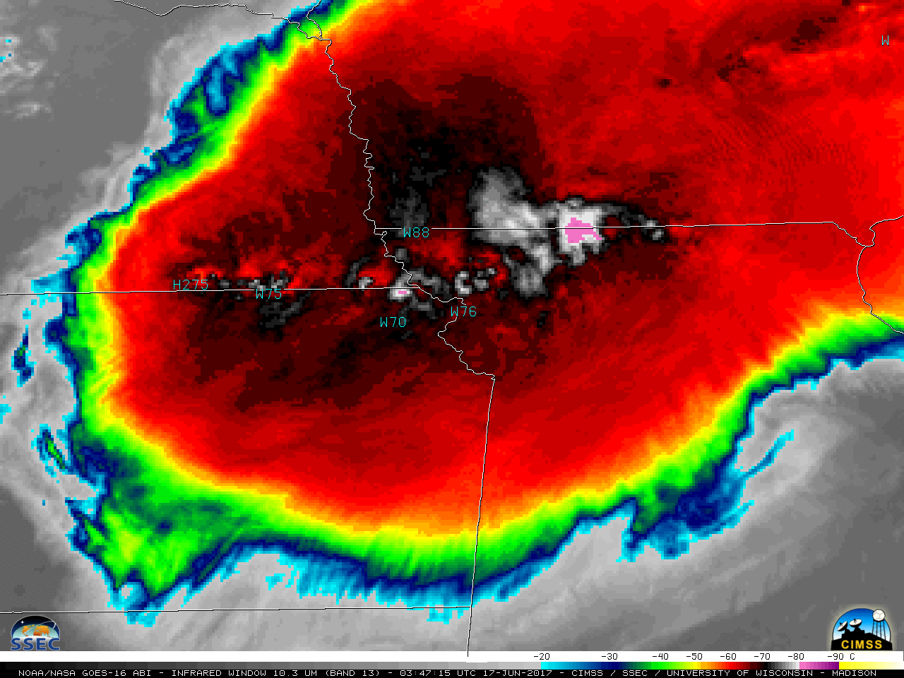
This website works best with a newer web browser such as Chrome, Firefox, Safari or Microsoft Edge. Internet Explorer is not supported by this website.

Meso-vortex over Qinghai Lake, China

We received the following notification on Twitter from Walt Clark: great meso-B MCV over Qinghai Lake in first light himawari 2230-630+Z. tough to get a good image loop of it tho. @CIMSS_Satellite — Walt Clark (@waclark4) December 18, 2015 Good catch Walt, and thanks for the heads-up! Using the Location Search feature... Read More

We received the following notification on Twitter from Walt Clark:

Good catch Walt, and thanks for the heads-up! Using the Location Search feature of RealEarth, we found that Qinghai Lake is located in central China, and Wikipedia told us it’s also the largest lake in China. (Qinghai Lake is slightly smaller than the Great Salt Lake in Utah) The mesoscale vortex can be seen over the lake on a Himawari-8 true-color Red/Green/Blue (RGB) image at 0400 UTC on 18 December 2015 (below).

Himawari-8 true-color image at 0400 UTC [click to play zoom-in animation]

Himawari-8 true-color image at 0400 UTC [click to play zoom-in animation]

Daytime Himawari-8 Visible (0.64 µm, 0.5-km resolution) images (below) showed the feature spinning cyclonically over Qinghai Lake as it slowly migrated northward.

Himawari-8 Visible (0.64 µm) images [click to play animation]

Himawari-8 Visible (0.64 µm) images [click to play animation]

However, we’re not certain that this was a Mesoscale Convective Vortex (MCV); while there was some convection over the mountains north of the lake during the preceding nighttime hours on 17 December which exhibited cloud-top IR brightness temperatures around -40º C (color-enhanced Himawari-8 Infrared animation), it appears more likely that this might have been a convective outflow boundary from those mountain thunderstorms which became trapped within the “bowl” of high terrain that nearly surrounds the lake. A long animation which concatenates the earlier nighttime Himawari-8 Infrared (10.4 µm, 2-km resolution) and the later daytime Himawari-8 Visible (0.64 µm, 0.5-km resolution) images is shown below. It is difficult to trace the origin of the vortex feature as being from the aforementioned convective activity.

Himawari-8 Infrared (10.4 µm) and Visible (0.64 µm) images [click to play animation]

Himawari-8 Infrared (10.4 µm) and Visible (0.64 µm) images [click to play animation]

The meso-vortex was also seen on a MODIS true-color RGB image from the Aqua satellite, which did an overpass of the region around 0642 UTC (below). While some small patches of ice did appear to be forming along the edges of Qinghai Lake, it remained predominantly ice-free (unlike the smaller and presumably more shallow Har Lake to the northwest, which looked to be totally ice-covered).

Aqua MODIS true-color RGB image, with Google maps background [click to enlarge]

Aqua MODIS true-color RGB image, with Google maps background [click to enlarge]

View only this post Read Less

Using RGB images for discrimination of clouds vs snow cover

On the afternoon of 16 December 2015, a toggle between Suomi NPP VIIRS Visible (0.64 µm, 375-m resolution) and False-color Red/Green/Blue (RGB) images (above) showed areas of snow cover (shades of red on the RGB image) that remained from separate snowfall events during the 13 December15 December time period (24-hour snowfall maps). Snow depth... Read More

Suomi NPP VIIRS Visible (0.64 µm) and False-color RGB images [click to enlarge]

Suomi NPP VIIRS Visible (0.64 µm) and False-color RGB images [click to enlarge]

On the afternoon of 16 December 2015, a toggle between Suomi NPP VIIRS Visible (0.64 µm, 375-m resolution) and False-color Red/Green/Blue (RGB) images (above) showed areas of snow cover (shades of red on the RGB image) that remained from separate snowfall events during the 13 December15 December time period (24-hour snowfall maps). Snow depth on the morning of 16 December was as high as 14 inches in the Foothills of eastern Colorado, 12 inches in both southeastern Wyoming and western Nebraska, and 4 inches in southwestern Kansas.

Comparing the false-color RGB image with the visible image made it easier to unambiguously discriminate between snow cover and supercooled water droplet cloud features (which appear as shades of white on the RGB image). In addition, consecutive VIIRS RGB images (below) showed the areas where snow cover was beginning to melt during the ~102 minutes between overpasses of the Suomi NPP satellite.

Suomi NPP VIIRS False-color RGB images at 1842 and 2025 UTC [click to enlarge]

Suomi NPP VIIRS False-color RGB images at 1842 and 2025 UTC [click to enlarge]

A late-morning overpass of the Landsat-8 satellite provided a 30-meter resolution view (below) of the circular and rectangular irrigated agricultural fields in far southwestern Kansas and parts of the Oklahoma panhandle. In this RGB image (viewed using RealEarth), snow cover appears as cyan; in areas without snow cover, bare ground is brown and vegetation (crops) are green.

Landsat-8 False-color RGB image, with Google maps background [click to enlarge]

Landsat-8 False-color RGB image, with Google maps background [click to enlarge]

View only this post Read Less

GOES-15 Rapid Scan Operations (RSO) sector for American Samoa

On 15 December 2015 NOAA/NESDIS conducted a test of the new GOES-15 (GOES-West) Rapid Scan Operations (RSO) sector for coverage of the American Samoa region (SSD message). GOES-15 Visible (0.63 µm, 1-km resolution) images during the test period between 1711 and 1957 UTC are shown above, with plots of surface observations for... Read More

GOES-15 Visible (0.63 µm) images [click to play animation]

GOES-15 Visible (0.63 µm) images [click to play animation]

On 15 December 2015 NOAA/NESDIS conducted a test of the new GOES-15 (GOES-West) Rapid Scan Operations (RSO) sector for coverage of the American Samoa region (SSD message). GOES-15 Visible (0.63 µm, 1-km resolution) images during the test period between 1711 and 1957 UTC are shown above, with plots of surface observations for Pago Pago (station identifier NSTU) and Faleolo (station identifier NSFA). Note that visible images from the Full Disk scan at 1800 UTC and Southern Hemisphere sectors at :22 past each hour are also included in the animation; during routine operations, there are periods when only 1 image per hour is available (from the Southern Hemisphere sector) which covers American Samoa.

The full size of the American Samoa RSO sector is shown below.

GOES-15 Visible (0.63 µm) image showing the size of the American Samoa RSO sector [click to enlarge]

GOES-15 Visible (0.63 µm) image showing the size of the American Samoa RSO sector [click to enlarge]

Displayed below is the American Samoa RSO sector is relation to the typical GOES-West Full Disk scan coverage.

GOES-15 Visible (0.63 µm) image showing the location of the American Samoa RSO sector in relation to the GOES-15 Full Disk scan coverage [click to enlarge]

GOES-15 Visible (0.63 µm) image showing the location of the American Samoa RSO sector in relation to the GOES-15 Full Disk scan coverage [click to enlarge]

The American Samoa RSO sector images were also successfully broadcast over the Satellite Broadcast Network (SBN) for display in AWIPS II; a sample GOES-15 Infrared (10.7 µm, 4-km resolution) image is shown below.

GOES-15 Infrared (10.7 µm) image, displayed using AWIPS II [click to enlarge]

GOES-15 Infrared (10.7 µm) image, displayed using AWIPS II [click to enlarge]

As a preview to the upcoming GOES-R series of satellites, we can examine JMA Himawari-8 Visible (0.64 µm, 0.5 km resolution) images for the same 3-hour time period, as seen below (sun glint over the open water is high during this time of day, due to the sun-satellite geometry of Himiwari-8 positioned at 140º East longitude). The images are available from the AHI instrument every 10 minutes, and show the development of organized clusters of convection just north and south of the larger islands of Samoa and Apia. Remote locations such as American Samoa will receive similar images every 5 minutes from the ABI instrument on GOES-R/S/T.

Himawari-8 Visible (0.64 µm) images [click to play animation]

Himawari-8 Visible (0.64 µm) images [click to play animation]

View only this post Read Less

Bore-like Gravity Wave Signatures over Texas

GOES-13 (above) and GOES-15 (below) both captured the propagation of gravity waves that displayed Bore-like attributes along an inversion with a cold front over central Texas. (Click here for an animation of GOES-13 and GOES-15 side-by-side that includes observed surface winds).There was a temperature drop across the front, and modest wind... Read More

GOES-13 Visible (0.63 µm) images [click to play animation]

GOES-13 Visible (0.63 µm) images [click to play animation]

GOES-13 (above) and GOES-15 (below) both captured the propagation of gravity waves that displayed Bore-like attributes along an inversion with a cold front over central Texas. (Click here for an animation of GOES-13 and GOES-15 side-by-side that includes observed surface winds).

GOES-15 Visible (0.63 µm) images [click to play animation]

GOES-15 Visible (0.63 µm) images [click to play animation]

There was a temperature drop across the front, and modest wind gusts occurred just after the lowest pressure associated with the feature passed, but those gusts occurred only in a narrow corridor in central Texas: KSNK (Snyder) reported gusts of 14 knots (0925 UTC); KSWW (Sweetwater) reported gusts of 15 knots (1035 UTC); KABI (Abilene) reported gusts to 17 knots (1152 UTC); KBWD (Brownwood) reported gusts to 24 knots at 1335 UTC; KMKN (Comanche) reported gusts of 22 knots at 1355 UTC (See also the image below). The narrowness of this corridor is likely related to the strength of the inversion along which the bore is propagating (The 1200 UTC Soundings from Fort Worth and from Del Rio both show a very strong inversion; perhaps there was a weakness in the inversion over central Texas that allowed for more vertical mixing).

GOES-13 Visible (0.63 µm) imagery at 1400 UTC; Station Locations are indicated, including the 5 stations with identifiable Wind Gusts associated with the Bore Feature [click to enlarge]

GOES-13 Visible (0.63 µm) imagery at 1400 UTC; Station Locations are indicated, including the 5 stations with identifiable Wind Gusts associated with the Bore Feature (Gust Strength in knots and time of Gust indicated) [click to enlarge]

During the preceding nighttime hours, the early stage of the undular bore feature was detected on an Aqua MODIS Water Vapor (6.7 µm) image, below, along the leading edge of the colder air and colder surface brightness temperatures (light to medium blue colors) seen on the corresponding MODIS Infrared (11.0 µm) image at 0807 UTC or 2:07 am local time.

Aqua MODIS Water Vapor (6.7 µm) and Infrared (11.0 µm) images [click to enlarge]

Aqua MODIS Water Vapor (6.7 µm) and Infrared (11.0 µm) images [click to enlarge]

(Hat tip to Mike Johnson, NWS in San Angelo for tweeting about this feature!)

View only this post Read Less