Suomi NPP VIIRS Visible (0.64 µm) and Infrared Window (11.45 µm) images (above) captured an unusually late thunderstorm that produced small hail at Anchorage PANC (surface observations) on 24 September 2018. The coldest cloud-top infrared brightness temperature was -53.8ºC, which was colder than the -46.3ºC tropopause temperature on the 00 UTC Anchorage sounding. This... Read More
![Suomi NPP VIIRS Visible (0.64 µm) and Infrared Window (11.45 µm) images [click to enlarge]](https://cimss.ssec.wisc.edu/satellite-blog/wp-content/uploads/sites/5/2018/09/180924_2215utc_suomiNPP_viirs_visible_infrared_PANC_TS_anim.gif)
Suomi NPP VIIRS Visible (0.64 µm) and Infrared Window (11.45 µm) images [click to enlarge]
Suomi NPP VIIRS Visible (0.64 µm) and Infrared Window (11.45 µm) images
(above) captured an unusually late thunderstorm that produced small hail at Anchorage PANC (
surface observations) on 24 September 2018. The coldest cloud-top infrared brightness temperature was -53.8ºC, which was colder than the -46.3ºC tropopause temperature on the
00 UTC Anchorage sounding. This particular thunderstorm (Anchorage averages only 1-2 per year) even featured a wall cloud:
In far northeastern Alaska, snow cover across the North Slope and Brooks Range was evident in a sequence of Suomi NPP VIIRS Visible (0.64 µm) images
(below). Since there were also areas of low cloud present (both north and south of the primary snow cover), the VIIRS Shortwave Infrared (3.74 µm) images could be used to discriminate between these low clouds — whose supercooled water droplets were effective reflectors of solar radiation, making then appear warmer or darker gray — and the cloud-free areas of snow cover.
![Sequence of 4 Suomi NPP VIIRS Visible (0.64 µm) and Shortwave Infrared (3.74 µm) images [click to enlarge]](https://cimss.ssec.wisc.edu/satellite-blog/wp-content/uploads/sites/5/2018/09/180924_suomiNPP_viirs_visible_shortwaveInfrared_Alaska_anim.gif)
Sequence of 4 Suomi NPP VIIRS Visible (0.64 µm) and Shortwave Infrared (3.74 µm) images [click to enlarge]
The presence of this snow cover aided strong nighttime radiational cooling as a ridge of high pressure moved over the North Slope (
surface analyses), and on the following morning temperatures dropped
as low as 4ºF (the temperature later reached 3ºF at Toolik Lake):
Finally, along the Alaska Peninsula, Suomi NPP VIIRS Day/Night Band (0.7 µm) and Shortwave Infrared (3.74 µm) images revealed the bright glow and hot thermal signature of the ongoing eruption of Mount Veniaminof at 1204 UTC and 1344 UTC (below).
![Suomi NPP VIIRS Day/Night Band (0.7 µm) and Shortwave Infrared (3.74 µm) images at 1204 UTC [click to enlarge]](https://cimss.ssec.wisc.edu/satellite-blog/wp-content/uploads/sites/5/2018/09/180925_1204utc_suomiNPP_viirs_DayNightBand_shortwaveInfrared_Veniaminof_AK_anim.gif)
Suomi NPP VIIRS Day/Night Band (0.7 µm) and Shortwave Infrared (3.74 µm) images at 1204 UTC [click to enlarge]
![Suomi NPP VIIRS Day/Night Band (0.7 µm) and Shortwave Infrared (3.74 µm) images at 1344 UTC [click to enlarge]](https://cimss.ssec.wisc.edu/satellite-blog/wp-content/uploads/sites/5/2018/09/180925_1344utc_suomiNPP_viirs_DayNightBand_shortwaveInfrared_Veniaminof_AK_anim.gif)
Suomi NPP VIIRS Day/Night Band (0.7 µm) and Shortwave Infrared (3.74 µm) images at 1344 UTC [click to enlarge]
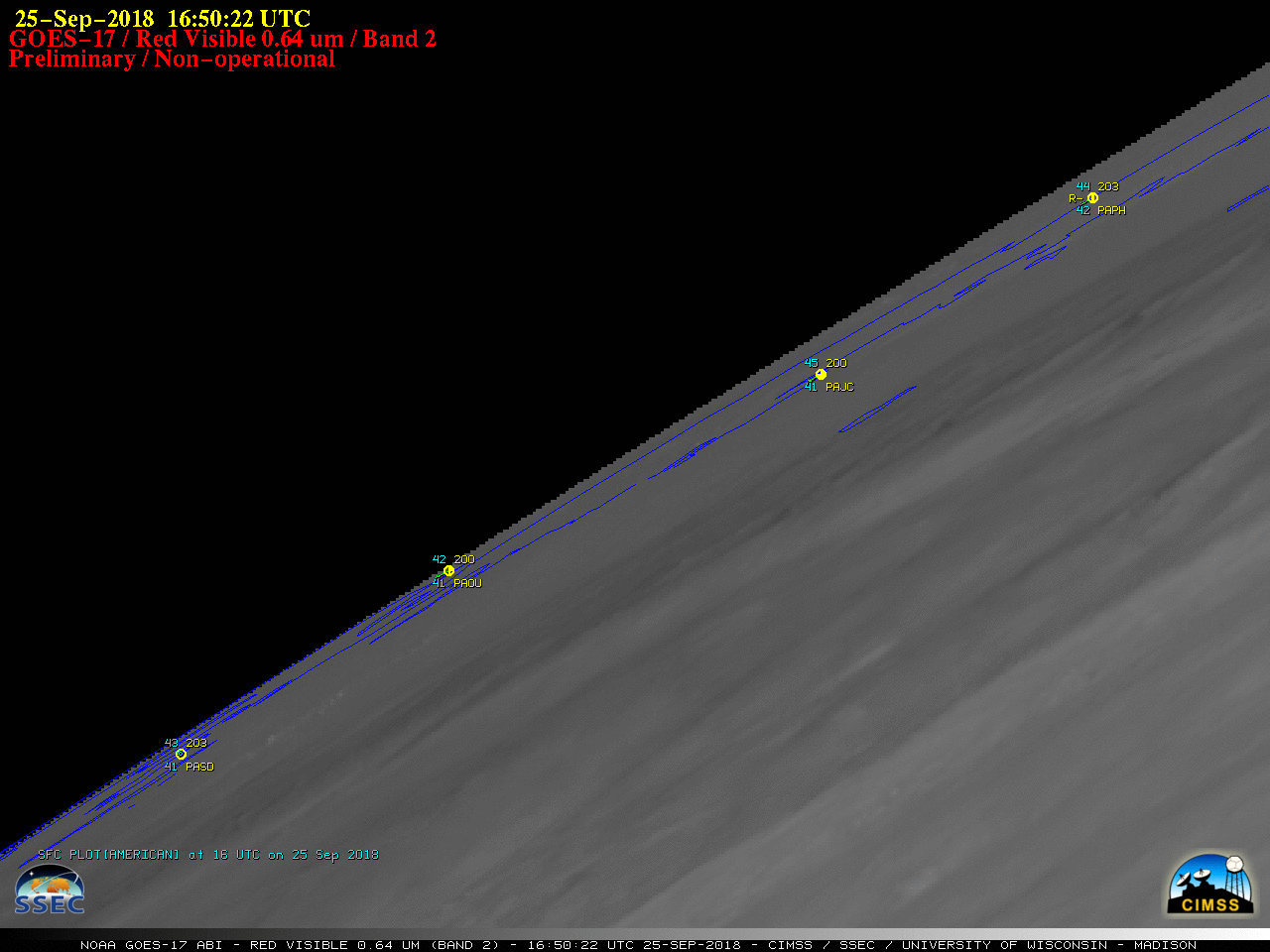
Coincidentally, on this day GOES-17 began a
test of Mode 6 operation which performs a Full Disk scan every 10 minutes. Although the Alaska Peninsula was on the extreme northwest limb of the Full Disk scan, Veniaminof’s thermal anomaly or “hot spot”
(darker black pixels) could still be detected and monitored at 10 minute intervals using Shortwave Infrared (
3.9 µm) imagery
(below). However, an increase in layered cloud cover southeast of that area later in the day (in tandem with the extreme satellite view angle) eventually masked the warm thermal signature — a more direct view from overhead with Suomi NPP VIIRS still showed a very hot volcano summit (96.9ºC)
at 2156 UTC.
![GOES-17 Shortwave Infrared (3.74 µm) images [click to play animation | MP4]](https://cimss.ssec.wisc.edu/satellite-blog/wp-content/uploads/sites/5/2018/09/G17_SWIR_VENIAMINOF_25SEP2018_960x1280_B7_2018268_151022_0001PANEL_00014.GIF)
GOES-17 Shortwave Infrared (3.74 µm) images [click to play animation | MP4]
Since there were no significant ash emissions from Mount Veniaminof on this day, no volcanic signature was evident on GOES-17 “Red” Visible (
0.64 µm) imagery
(below).

GOES-17 “Red” Visible (0.64 µm) images [click to play animation | MP4]
* GOES-17 images shown here are preliminary and non-operational *
View only this post
Read Less


![Suomi NPP VIIRS Visible (0.64 µm) and Infrared Window (11.45 µm) images [click to enlarge]](https://cimss.ssec.wisc.edu/satellite-blog/wp-content/uploads/sites/5/2018/09/180924_2215utc_suomiNPP_viirs_visible_infrared_PANC_TS_anim.gif)
![Sequence of 4 Suomi NPP VIIRS Visible (0.64 µm) and Shortwave Infrared (3.74 µm) images [click to enlarge]](https://cimss.ssec.wisc.edu/satellite-blog/wp-content/uploads/sites/5/2018/09/180924_suomiNPP_viirs_visible_shortwaveInfrared_Alaska_anim.gif)
![Suomi NPP VIIRS Day/Night Band (0.7 µm) and Shortwave Infrared (3.74 µm) images at 1204 UTC [click to enlarge]](https://cimss.ssec.wisc.edu/satellite-blog/wp-content/uploads/sites/5/2018/09/180925_1204utc_suomiNPP_viirs_DayNightBand_shortwaveInfrared_Veniaminof_AK_anim.gif)
![Suomi NPP VIIRS Day/Night Band (0.7 µm) and Shortwave Infrared (3.74 µm) images at 1344 UTC [click to enlarge]](https://cimss.ssec.wisc.edu/satellite-blog/wp-content/uploads/sites/5/2018/09/180925_1344utc_suomiNPP_viirs_DayNightBand_shortwaveInfrared_Veniaminof_AK_anim.gif)

![Himawari-8 Infrared Window (10.4 µm) images, with deep-layer wind shear analysis at 00 UTC [click to enlarge]](https://cimss.ssec.wisc.edu/satellite-blog/wp-content/uploads/sites/5/2018/09/180924_himawari8_infrared_00utc_shear_Trami_anim.gif)
![NOAA-20 VIIRS Day/Night Band (0.7 µm) and Infrared Window (11.45 µm) images [click to enlarge]](https://cimss.ssec.wisc.edu/satellite-blog/wp-content/uploads/sites/5/2018/09/180925_1634utc_noaa20_DayNightBand_InfraredWindow_Trami_anim.gif)


![VIIRS Day/Night Band (0.7 µm) images from Suomi NPP at 0743 UTC and NOAA-20 at 0832 UTC [click to enlarge]](https://cimss.ssec.wisc.edu/satellite-blog/wp-content/uploads/sites/5/2018/09/180923_suomiNPP_noaa20_viirs_DayNightBand_Lake_Michigan_anim.gif)
![Terra/Aqua MODIS Sea Surface Temperature product [click to enlarge]](https://cimss.ssec.wisc.edu/satellite-blog/wp-content/uploads/sites/5/2018/09/180923_modis_SeaSurfaceTemperature_Lake_Michigan_anim.gif)
![Terra/Aqua MODIS Sea Surface Temperature product, with RTMA surface winds [click to enlarge]](https://cimss.ssec.wisc.edu/satellite-blog/wp-content/uploads/sites/5/2018/09/180923_modis_SeaSurfaceTemperature_rtma_surface_winds_Lake_Michigan_anim.gif)
![Terra MODIS Sea Surface Temperature product, with RTMA surface winds and Metop ASCAT winds [click to enlarge]](https://cimss.ssec.wisc.edu/satellite-blog/wp-content/uploads/sites/5/2018/09/180923_terra_modis_sst_rtma_ascat_winds_anim.gif)
