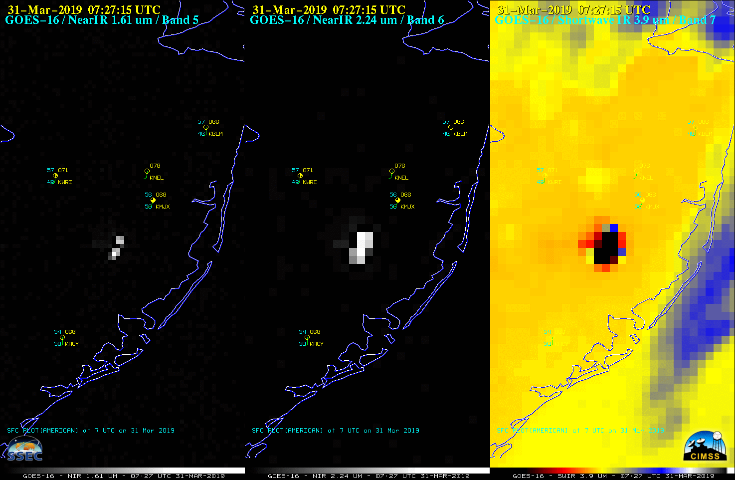
The Spring Hill Fire began to burn in central New Jersey around 1745 UTC (1:45 PM EDT) on 30 March 2019. GOES-16 (GOES-East) Near-Infrared “Snow/Ice” (1.61 µm), Near-Infrared “Cloud Particle Size” (2.24 µm) and Shortwave Infrared (3.9 µm) images (above) showed the hot thermal signature of the fire as it burned into the subsequent nighttime hours and... Read More
![GOES-16 Near-Infrared “Snow/Ice” (1.61 µm, left), Near-Infrared “Cloud Particle Size” (2.24 µm, center) and Shortwave Infrared (3.9 µm, right) images [click to play animation | MP4]](https://cimss.ssec.wisc.edu/satellite-blog/wp-content/uploads/sites/5/2019/03/G16_NIR_SWIR_NJ_FIRE_30MAR2019_2019090_072715_GOES-16_0003PANELS.GIF)
GOES-16 Near-Infrared “Snow/Ice” (1.61 µm, left), Near-Infrared “Cloud Particle Size” (2.24 µm, center) and Shortwave Infrared (3.9 µm, right) images [click to play animation | MP4]
The
Spring Hill Fire began to burn in central New Jersey around 1745 UTC (1:45 PM EDT) on
30 March 2019. GOES-16
(GOES-East) Near-Infrared “Snow/Ice” (
1.61 µm), Near-Infrared “Cloud Particle Size” (
2.24 µm) and Shortwave Infrared (
3.9 µm) images
(above) showed the hot thermal signature of the fire as it burned into the subsequent nighttime hours and the following morning. Smoke from the fire drifted northeastward, reducing the surface visibility at Lakehurst Naval Air Station (
KNEL), Toms River (
KMJX) and Belmar (
KBLM).
GOES-16 also initially viewed this area with 1-minute imagery from 1700-1859 UTC (since the Mesoscale Sector #1 normally covers New Jersey), and first displayed a fire hot spot around 1745 UTC. The animation below shows Visible imagery (0.64 µm), with Shortwave Infrared imagery in the background. One-minute data was valuable during these two hours because the rapidly moving clouds occasionally allowed brief views of the surface. It’s also easier to identify the smoke plume as a coherent structure with a 1-minute cadence (vs. the 5-minute cadence available with CONUS scans). At 1900 UTC, GOES-16 Mesoscale Sector #1 was repositioned to cover developing convection over the mid-Mississippi River Valley, so 1-minute views of New Jersey were terminated.

GOES-16 “Red” Visible (0.64 µm) imagery, with Shortwave Infrared (3.9 µm) pixels displayed through the semi-transparent visible images [click to play animation | MP4]
The GOES Fire Detection and Characterization Algorithm (the Baseline fire-detection product) is shown below. This product is not computed in Mesoscale Domains, so only CONUS imagery with a 5-minute cadence is shown. The widespread cloud cover affected the signal, but the fire was still detected. Note that the Fire Power product identified the fire pixels more frequently (consider the
1832 UTC image, for example).
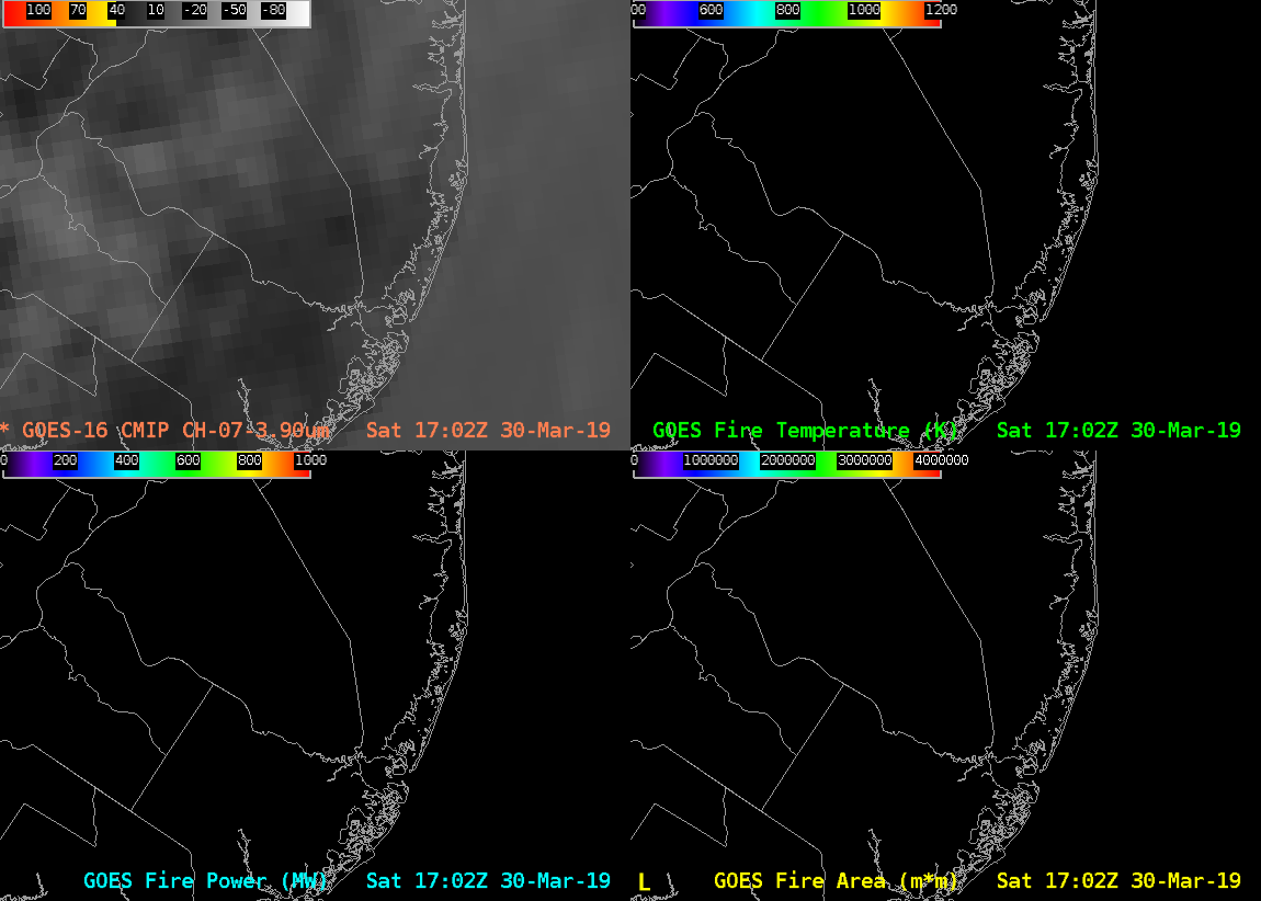
GOES-16 Shortwave Infrared (3.9 µm, upper left), GOES Fire Temperature (upper right), GOES Fire Area (lower right) and GOES Fire Power (lower left) [click to play animation | MP4]
The rapid growth of the fire thermal signature was apparent in a sequence of 3 daytime and 3 nighttime VIIRS Shortwave Infrared (3.74 µm) images from NOAA-20 and Suomi NPP
(below). Note: some of the NOAA-20 images — 1750 UTC on 30 March, along with 0609 and 0749 UTC on 31 March — are incorrectly labeled as Suomi NPP.
![NOAA-20 and Suomi NPP VIIRS Shortwave Infrared (3.74 µm) images [click to enlarge]](https://cimss.ssec.wisc.edu/satellite-blog/wp-content/uploads/sites/5/2019/03/190330_190331_viirs_shortwaveInfrared_Spring_Hill_Fire_NJ_anim.gif)
NOAA-20 and Suomi NPP VIIRS Shortwave Infrared (3.74 µm) images [click to enlarge]
Signatures of the fire were also seen in a comparison of Suomi NPP VIIRS Near-Infrared (1.61 µm and 2.24 µm), Shortwave Infrared (3.74 µm) and Day/Night Band (0.7 µm) images
(below, courtesy of William Straka, CIMSS).
![Suomi NPP VIIRS Near-Infrared (1.61 µm and 2.24 µm), Shortwave Infrared (3.74 µm) and Day/Night Band (0.7 µm) images [click to enlarge]](https://cimss.ssec.wisc.edu/satellite-blog/wp-content/uploads/sites/5/2019/03/190331_0703utc_suomiNPP_nearInfrared_shortwaveInfrared_dayNightBand_Spring_Hill_Fire_NJ_anim.gif)
Suomi NPP VIIRS Near-Infrared (1.61 µm and 2.24 µm), Shortwave Infrared (3.74 µm) and Day/Night Band (0.7 µm) images [click to enlarge]
===== 01 April Update =====
![Terra MODIS True Color and False Color images on 01 April [cick to enlarge]](https://cimss.ssec.wisc.edu/satellite-blog/wp-content/uploads/sites/5/2019/03/190401_terra_modis_truecolor_falsecolor_Spring_Hill_Fire_NJ_burn_scar_anim.gif)
Terra MODIS True Color and False Color RGB images on 01 April [click to enlarge]
In a comparison of Terra MODIS True Color and False Color RGB images on 01 April from the
MODIS Today site
(above) the fire burn scar was evident in the False Color image.
The appearance of the burn scar was also seen in a before/after toggle between Terra MODIS False Color RGB images on 27 March and 01 April (below).
![Terra MODIS False Color RGB images on 28 March and 01 April [click to enlarge]](https://cimss.ssec.wisc.edu/satellite-blog/wp-content/uploads/sites/5/2019/03/190327_190401_terra_modis_falsecolor_Spring_Hill_Fire_NJ_burn_scar_anim.gif)
Terra MODIS False Color RGB images on 28 March and 01 April [click to enlarge]
A closer view of the 01 April Terra MODIS False Color RGB image using
RealEarth (below) showed that the northeastern edge of the burn scar was near Route 72 (which had to be closed as the fire was being contained), and may have threatened structures at
Coyle Field.
![Terra MODIS False Color RGB and Google Maps background images [click to enlarge]](https://cimss.ssec.wisc.edu/satellite-blog/wp-content/uploads/sites/5/2019/03/190401_1625utc_terra_modis_falsecolor_NJ_anim.gif)
Terra MODIS False Color RGB and Google Maps background images [click to enlarge]
===== 08 April Update =====
![Landsat-8 False Color RGB image, with Google Maps background [click to enlarge]](https://cimss.ssec.wisc.edu/satellite-blog/wp-content/uploads/sites/5/2019/04/190408_1534utc_landsat8_falsecolor_Spring_Hill_Fire_NJ_burn_scar_anim.gif)
Landsat-8 False Color RGB image, with Google Maps background [click to enlarge]
A 30-meter resolution Landsat-8 False Color RGB image from 08 April
(above) provided a very detailed view of the Spring Hill Fire burn scar. It suggested that the fire did cross Route 72 at Coyle Field.
View only this post
Read Less
![GOES-16 "Red" Visible (0.64 µm) images [click to play animation | MP4]](https://cimss.ssec.wisc.edu/satellite-blog/wp-content/uploads/sites/5/2019/04/nc_vis-20190402_210127.png)
![GOES-16 Low-level (7.3 µm), Mid-level (6.9 µm) and Upper-level (6.2 µm) Water Vapor images [click to play animation | MP4]](https://cimss.ssec.wisc.edu/satellite-blog/wp-content/uploads/sites/5/2019/04/G16_WATER_VAPOR_BOMB_CYCLONE_02APR2019_2019092_194619_GOES-16_0003PANELS_A.gif)
![GOES-16 "Clean" Infrared Window (10.3 µm) images [click to play MP4 animation]](https://cimss.ssec.wisc.edu/satellite-blog/wp-content/uploads/sites/5/2019/04/nc_ir-20190403_004827.png)
![Terra and Aqua MODIS Infrared Window (11.0 µm) images from 0237 UTC and 0649 UTC, along with the Aqua MODIS Sea Surface Temperature product at 1755 UTC [click to enlarge]](https://cimss.ssec.wisc.edu/satellite-blog/wp-content/uploads/sites/5/2019/04/190403_modis_infraredWindow_seaSurfaceTemperature_bomb_cyclone_2_anim.gif)
![NOAA-20 VIIRS Infrared Window (11.45 µµ) and Day/Night Band (0.7 µm) images [click to enlarge]](https://cimss.ssec.wisc.edu/satellite-blog/wp-content/uploads/sites/5/2019/04/190403_0651utc_noaa20_infraredWindow_dayNightBand_surfaceAnalysis_coastal_low_anim.gif)




![NOAA-20 and Suomi NPP VIIRS Shortwave Infrared (3.74 µm) images [click to enlarge]](https://cimss.ssec.wisc.edu/satellite-blog/wp-content/uploads/sites/5/2019/03/190330_190331_viirs_shortwaveInfrared_Spring_Hill_Fire_NJ_anim.gif)
![Suomi NPP VIIRS Near-Infrared (1.61 µm and 2.24 µm), Shortwave Infrared (3.74 µm) and Day/Night Band (0.7 µm) images [click to enlarge]](https://cimss.ssec.wisc.edu/satellite-blog/wp-content/uploads/sites/5/2019/03/190331_0703utc_suomiNPP_nearInfrared_shortwaveInfrared_dayNightBand_Spring_Hill_Fire_NJ_anim.gif)
![Terra MODIS True Color and False Color images on 01 April [cick to enlarge]](https://cimss.ssec.wisc.edu/satellite-blog/wp-content/uploads/sites/5/2019/03/190401_terra_modis_truecolor_falsecolor_Spring_Hill_Fire_NJ_burn_scar_anim.gif)
![Terra MODIS False Color RGB images on 28 March and 01 April [click to enlarge]](https://cimss.ssec.wisc.edu/satellite-blog/wp-content/uploads/sites/5/2019/03/190327_190401_terra_modis_falsecolor_Spring_Hill_Fire_NJ_burn_scar_anim.gif)
![Terra MODIS False Color RGB and Google Maps background images [click to enlarge]](https://cimss.ssec.wisc.edu/satellite-blog/wp-content/uploads/sites/5/2019/03/190401_1625utc_terra_modis_falsecolor_NJ_anim.gif)
![Landsat-8 False Color RGB image, with Google Maps background [click to enlarge]](https://cimss.ssec.wisc.edu/satellite-blog/wp-content/uploads/sites/5/2019/04/190408_1534utc_landsat8_falsecolor_Spring_Hill_Fire_NJ_burn_scar_anim.gif)
![GOES-16 Near-Infrared "Snow/Ice" (1.61 µm, left), Near-Infrared "Cloud Particle Size" (2.24 µm, center) and Shortwave Infrared (3.9 µm, right) images, with 1-minute plots of GLM Events [click to enlarge]](https://cimss.ssec.wisc.edu/satellite-blog/wp-content/uploads/sites/5/2019/03/190331_goes16_nearInfrared_shortwaveInfrared_glm_FL_meteor_anim.gif)
