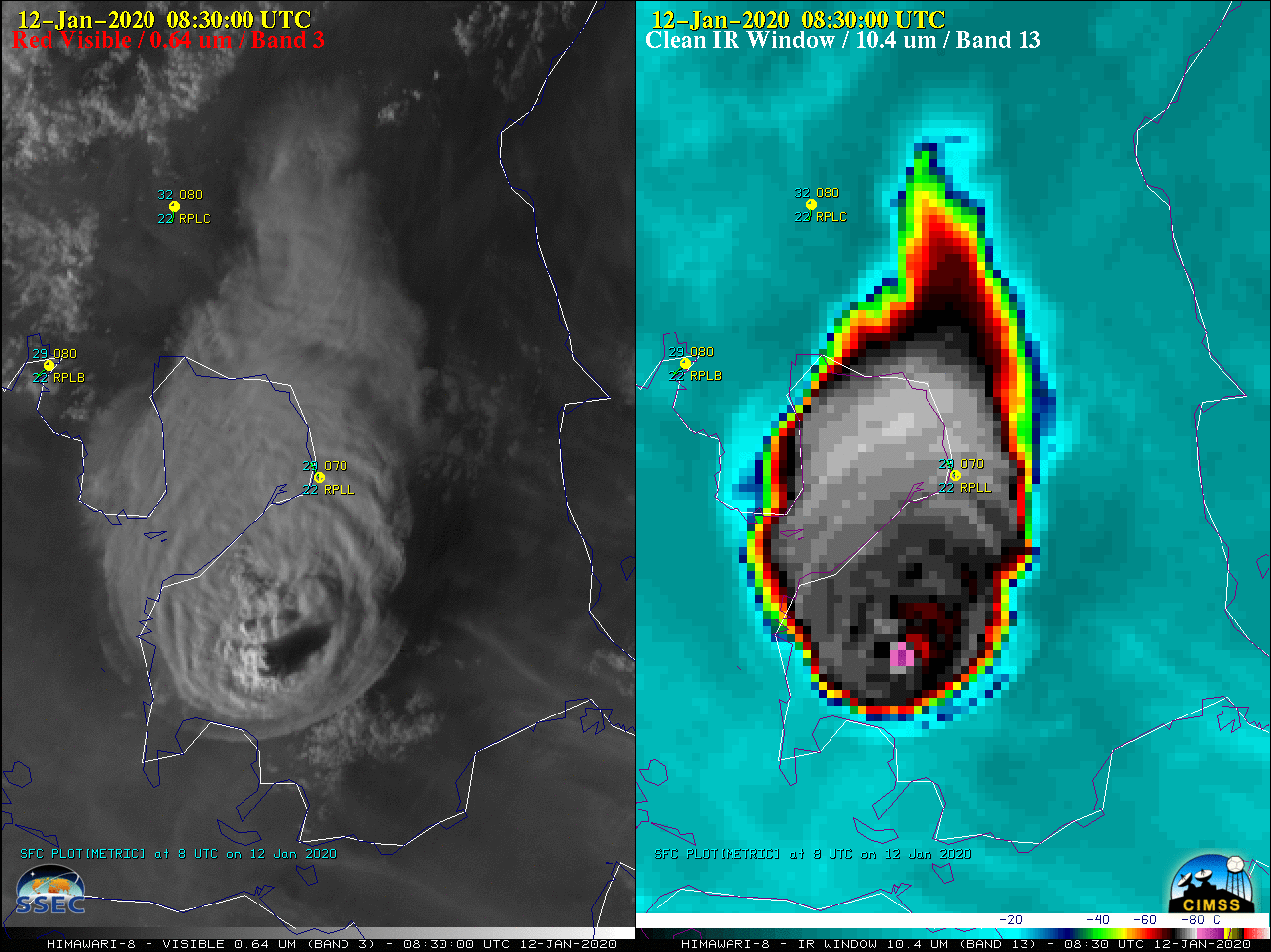
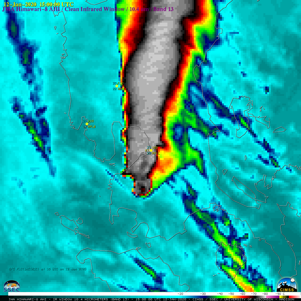
The Taal Volcano erupted in the Philippines around 0850 UTC on 12 January 2020. JMA Himawari-8 “Red” Visible (0.64 µm) and “Clean” Infrared Window (10.4 µm) images (above) displayed the volcanic cloud during the initial 3 hours post-eruption. Note the presence of a pronounced “warm wake” (red enhancement) downwind (north) of... Read More

Himawari-8 “Red” Visible (0.64 µm, left) and “Clean” Infrared Window (10.4 µm, right) images [click to play animation | MP4]
The
Taal Volcano erupted in the Philippines around 0850 UTC on 12 January 2020. JMA Himawari-8 “Red” Visible (0.64 µm) and “Clean” Infrared Window (10.4 µm) images
(above) displayed the volcanic cloud during the initial 3 hours post-eruption. Note the presence of a pronounced “warm wake”
(red enhancement) downwind (north) of the summit of Taal — this appeared to be an
Above-Anvil Cirrus Plume (AACP), as seen in a toggle between the Visible and Infrared images at 1910 UTC
(below).
![Himawari-8 "Red" Visible (0.64 µm) and "Clean" Infrared Window (10.4 µm) images at 1910 UTC [click to enlarge]](https://cimss.ssec.wisc.edu/satellite-blog/images/2020/01/200112_0910utc_himawari8_visible_infrared_Tall_anim.gif)
Himawari-8 “Red” Visible (0.64 µm) and “Clean” Infrared Window (10.4 µm) images at 1910 UTC [click to enlarge]
(
Legaspi,
Mactan and
Laoag)
(below).
![Plots of rawinsonde data from Legaspi, Mactan and Laoag in the Philippines [click to enlarge]](https://cimss.ssec.wisc.edu/satellite-blog/images/2020/01/200112_RPMP_RPMT_RPLI_raobs_anim.gif)
Plots of rawinsonde data from Legaspi, Mactan and Laoag in the Philippines [click to enlarge]
The TROPOMI detected SO2 at altitude of 20km on 13 January:
A longer animation of Himawari-8 Infrared imagery revealed the intermittent presence of the warm wake feature until about 1400 UTC. The coldest 10.4 µm cloud-top brightness temperature was -89.7ºC.
![Himawari-8 "Clean" Infrared Window (10.4 µm) images [click to play animation | MP4]](https://cimss.ssec.wisc.edu/satellite-blog/images/2020/01/HIM08_IR_TAAL_ZOOM_12JAN2020_B13_2020012_115000_HIMAWARI-8_0001PANEL_FRAME00033.GIF)
Himawari-8 “Clean” Infrared Window (10.4 µm) images [click to play animation | MP4]
A large-scale view of Himawari-8 Infrared images
(below) showed that the volcanic cloud was advected a great distance north-northeastward.
![Himawari-8 "Clean" Infrared Window (10.4 µm) images [click to play animation | MP4]](https://cimss.ssec.wisc.edu/satellite-blog/images/2020/01/HIM08_IR_TAAL_12JAN2020_B13_2020012_115000_HIMAWARI-8_0001PANEL_FRAME00033.GIF)
Himawari-8 “Clean” Infrared Window (10.4 µm) images [click to play animation | MP4]
A toggle between NOAA-20 VIIRS Day/Night Band (0.7 µm) and Infrared Window (11.45 µm) images
(below) showed the volcanic cloud at 1649 UTC.
![NOAA-20 VIIRS Day/Night Band (0.7 µm) and Infrared Window (11.45 µm) images at 1648 UTC (credit: William Straka, CIMSS) [click to enlarge]](https://cimss.ssec.wisc.edu/satellite-blog/images/2020/01/200112_1648utc_noaa20_viirs_dayNightBand_infraredWindow_Taal_anim.gif)
NOAA-20 VIIRS Day/Night Band (0.7 µm) and Infrared Window (11.45 µm) images at 1648 UTC (credit: William Straka, CIMSS) [click to enlarge]
In a sequence of Split Window Difference (11-12 µm) images (Terra MODIS, NOAA-20 VIIRS and Suomi NPP VIIRS) from the
NOAA/CIMSS Volcanic Cloud Monitoring site
(below), there was only a subtle ash signature
(blue enhancement) immediately downwind of the Taal summit — due to the large amount of ice within the upper portion of the volcanic cloud, the infrared spectral ash signature was significantly masked.
![Split Window Difference (11-12 um) images from Terra MODIS, NOAA-20 VIIRS and Suomi NPP VIIRS [click to enlarge]](https://cimss.ssec.wisc.edu/satellite-blog/images/2020/01/200112_modis_viirs_splitWindowDifference_Taal_anim.gif)
Split Window Difference (11-12 µm) images from Terra MODIS, NOAA-20 VIIRS and Suomi NPP VIIRS [click to enlarge]
Of interest was the fact that Manila International Airport (
RPLL) reported a thunderstorm at
15 UTC — there was a large amount of lightning produced by Taal’s volcanic cloud.
===== 14 January Update =====
![GOES-17 SO2 RGB images [click to play animation | MP4]](https://cimss.ssec.wisc.edu/satellite-blog/images/2020/01/g17_so2_taal-20200114_123032.png)
GOES-17 SO2 RGB images [click to play animation | MP4]
2 days after the eruption, the leading edge of Taal’s SO2-rich volcanic plume
(brighter shades of yellow over areas of cold clouds) began to appear within the far western view of GOES-17
(GOES-West) Full Disk
SO2 Red-Green-Blue (RGB) images
(above), about 1000 miles southeast of Japan. There were also some thin filaments of SO2
(brighter shades of white over warm ocean areas) moving southward, about 1500 miles west of Hawai’i.
View only this post
Read Less
![Plots of rawinsonde data from Fiji [click to enlarge]](https://cimss.ssec.wisc.edu/satellite-blog/images/2020/01/200116_NFFN_RAOBS.GIF)
![Plots of deep-layer wind shear [click to enlarge]](https://cimss.ssec.wisc.edu/satellite-blog/images/2020/01/200116_deepLayerWindShear_Tino_anim.gif)

![Himawari-8 "Clean" Infrared Window (10.4 µm) images [click to play animation | MP4]](https://cimss.ssec.wisc.edu/satellite-blog/images/2020/01/200112_himawari8_infrared_zoom_Taal_anim.gif)
![Himawari-8 "Clean" Infrared Window (10.4 µm) images [click to play animation | MP4]](https://cimss.ssec.wisc.edu/satellite-blog/images/2020/01/200112_himawari8_infrared_Taal_anim.gif)
![GOES-17 SO2 RGB images [click to play animation | MP4]](https://cimss.ssec.wisc.edu/satellite-blog/images/2020/01/200114_goes17_so2RGB_Taal_anim.gif)
![GOES-16 "Red" Visible (0.64 µm) images, including plot of SPC Storm Reports (with and without parallax correction) [click to play animation]](https://cimss.ssec.wisc.edu/satellite-blog/images/2020/01/200110_goes16_visible_spcStormReports_parallax_KS_MO_OK_AR_anim.gif)
![GOES-16 "Red" Visible (0.64 µm) image at 2030 UTC, including plot of SPC Storm Reports (with and without parallax correction) [click to enlarge]](https://cimss.ssec.wisc.edu/satellite-blog/images/2020/01/200110_2030utc_goes16_visible_spcStormReport_parallax_anim.gif)
![GOES-16 "Red" Visible (0.64 µm) image at 2051 UTC, including plot of Tornado report (with and without parallax correction) [click to enlarge]](https://cimss.ssec.wisc.edu/satellite-blog/images/2020/01/200110_2051utc_goes16_visible_spcStormReport_parallax_anim.gif)
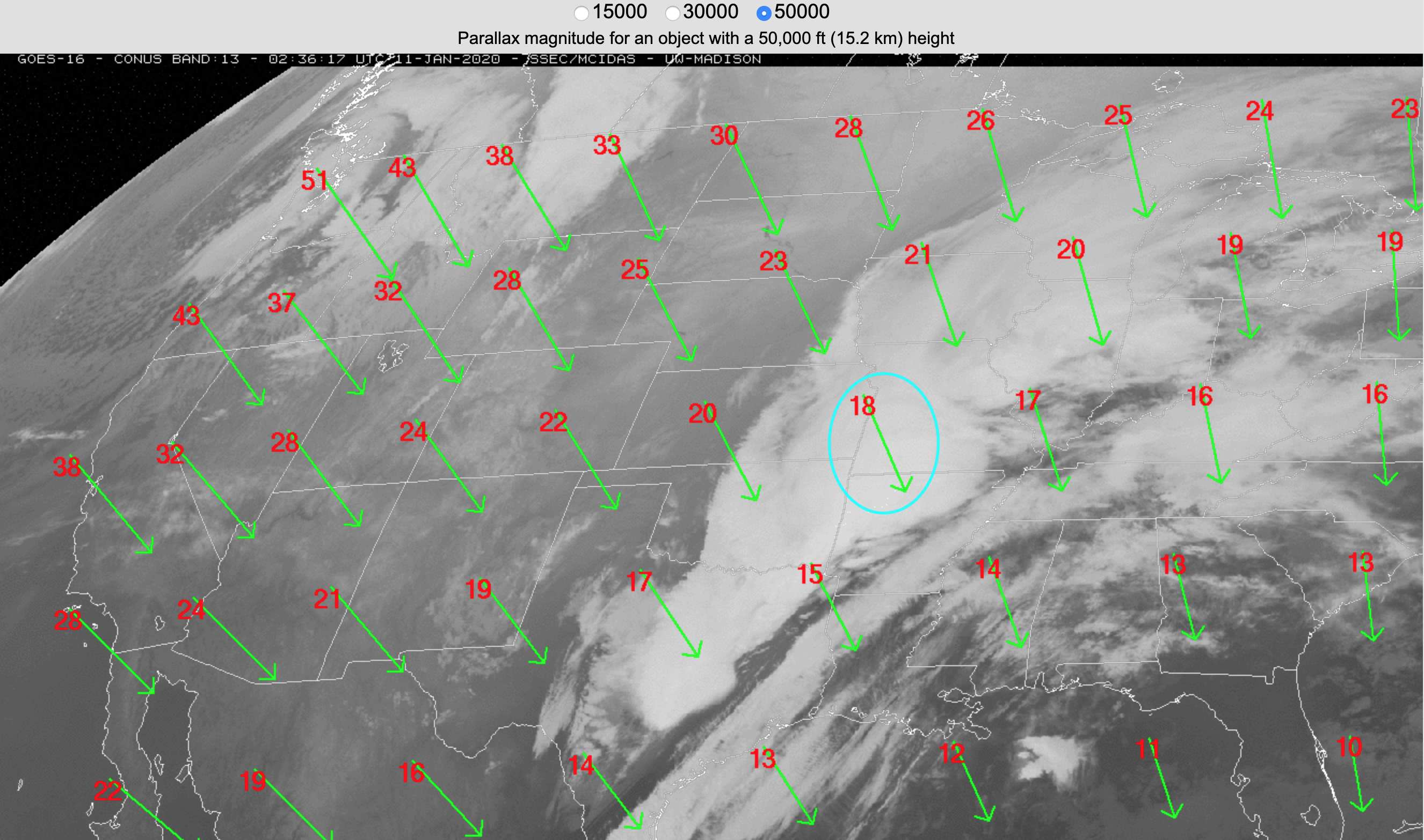
![GOES-16 parallax direction vectors and magnitude (km) for a cloud top feature at 15 km [click to enlarge]](https://cimss.ssec.wisc.edu/satellite-blog/images/2020/01/200110_KS_MO_parallax.png)
![GOES-17 parallax correction direction vectors and magnitude (km) for a cloud top feature at 50,000 feet (15.2 km) [click to enlarge]](https://cimss.ssec.wisc.edu/satellite-blog/images/2020/01/goes17_parallax_fulldisk.png)


