This website works best with a newer web browser such as Chrome, Firefox, Safari or Microsoft Edge. Internet Explorer is not supported by this website.

The May 1980 Mount St. Helens eruption

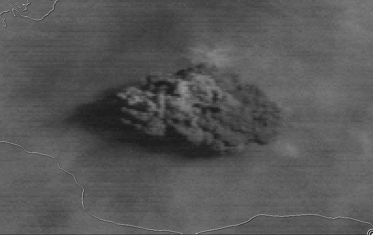
NOAA GOES-3 Visible (0.65 µm) images at 1545 and 1615 UTC (above) showed the volcanic cloud shortly after the explosive eruption of Mount St. Helens on 18 May 1980. GOES-3 was decommissioned in 2016.The corresponding GOES-3 Infrared (11.5 µm) image at 1545 UTC (below) appeared to display a small “enhanced-V” or cold/warm (-65ºC/-47ºC)... Read More

GOES-3 Visible (0.65 µm) images at 1545 and 1615 UTC [click to enlarge]

GOES-3 Visible (0.65 µm) images at 1545 and 1615 UTC [click to enlarge]

NOAA GOES-3 Visible (0.65 µm) images at 1545 and 1615 UTC (above) showed the volcanic cloud shortly after the explosive eruption of Mount St. Helens on 18 May 1980. GOES-3 was decommissioned in 2016.

The corresponding GOES-3 Infrared (11.5 µm) image at 1545 UTC (below) appeared to display a small “enhanced-V” or cold/warm (-65ºC/-47ºC) thermal couplet signature downwind (east) of the volcanic cloud’s overshooting top.

GOES-3 Infrared (11.5 µm) image at 1545 UTC [click to enlarge]

GOES-3 Infrared (11.5 µm) image at 1545 UTC [click to enlarge]

A comparison of GOES-3 Visible and Infrared images (below) showed that a large portion of the volcanic cloud exhibited IR brightness temperatures of -60ºC or colder (darker red color enhancement) as the feature moved rapidly eastward during the first 10 hours following the eruption.

GOES-3 Visible (0.65 µm, top) and Infrared Window (11.5 µm, bottom) images [click to play animation]

GOES-3 Visible (0.65 µm, top) and Infrared (11.5 µm, bottom) images [click to play animation]

The volcanic cloud was also captured on NASA SMS-2 Visible (0.62 µm) and Infrared (11.6 µm) imagery (below). An animation that cycles through both SMS-2 Visible and Infrared images can be seen here.

NASA SMS 2 Visible (0.62 µm) images (credit: Tim Schmit, ASPB/CIMSS) [click to play MP4 anmation]

NASA SMS-2 Visible (0.62 µm) images (credit: Tim Schmit, ASPB/CIMSS) [click to play MP4 animation]

NASA SMS 2 Infrared (11.6 µm) images (credit: Tim Schmit, ASPB/CIMSS) [click to play MP4 animation]

NASA SMS-2 Infrared (11.6 µm) images (credit: Tim Schmit, ASPB/CIMSS) [click to play MP4 animation]

SMS-2 “Visible/Infrared Sandwich” Red-Green-Blue (RGB) images are shown below.

NASA SMS-2 Visible/Infrared Sandwich RGB images (credit: Tim Schmit, ASPB/CIMSS) [click to play MP4 animation]

NASA SMS-2 Visible/Infrared Sandwich RGB images (credit: Tim Schmit, ASPB/CIMSS) [click to play MP4 animation]

Archived GOES-3 and SMS-2 imagery was provided by SSEC Satellite Data Services.

The ability to monitor volcanic ash plumes and their attributes has greatly improved from 1980 to today — moving from qualitative (somewhat after the fact imagery) to quantitative applications (that are more frequent, and therefore much more timely!). Due to the large number of volcanoes worldwide, satellite observations are key in monitoring the Earth’s volcanoes for aviation safety and other applications. More on volcanic cloud monitoring.

View only this post Read Less

Tropical Storm Arthur forms off the coast of Florida

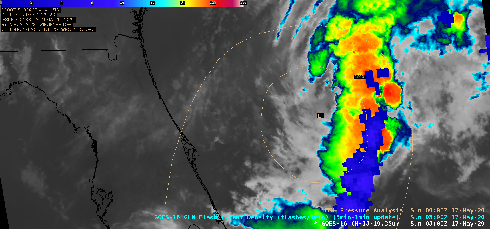
1-minute Mesoscale Domain Sector GOES-16 (GOES-East) “Clean” Infrared Window (10.35 µm) images, with and without an overlay of GLM Flash Extent Density (above) showed the period leading up to the formation of Tropical Storm Arthur during the evening of 16 May 2020 (at 03 UTC on 17 May) — making it the first tropical cyclone of the season in... Read More

GOES-16

GOES-16 “Clean” Infrared Window (10.35 µm) images, with and without an overlay of GLM Flash Extent Density [click to play animation | MP4]

1-minute Mesoscale Domain Sector GOES-16 (GOES-East) “Clean” Infrared Window (10.35 µm) images, with and without an overlay of GLM Flash Extent Density (above) showed the period leading up to the formation of Tropical Storm Arthur during the evening of 16 May 2020 (at 03 UTC on 17 May) — making it the first tropical cyclone of the season in the Atlantic Basin. There were periods of lightning activity within the elongated cluster of deep convection east of the storm center.

==== 17 May Update =====

GOES-16 "Red" Visible (0.64 µm) images [click to play animation | MP4]

GOES-16 “Red” Visible (0.64 µm) images [click to play animation | MP4]

During most of the day on 17 May, the low-level circulation center of Arthur was easily seen in 1-minute GOES-16 “Red” Visible (0.64 µm) images (above).

The corresponding GOES-16 Infrared images — with and without an overlay of GLM Flash Extent Density — are shown below.

GOES-16 "Clean" Infrared Window (10.35 µm) images, with and without an overlay of GLM Flash Extent Density [click to play animation | MP4]

GOES-16 “Clean” Infrared Window (10.35 µm) images, with and without an overlay of GLM Flash Extent Density [click to play animation | MP4]

===== 18 May Update =====

GOES-16 "Red" Visible (0.64 µm) images [click to play animation | MP4]

GOES-16 “Red” Visible (0.64 µm) images [click to play animation | MP4]

1-minute GOES-16 Visible images (above) showed that the low-level circulation center of Arthur became exposed during the day on 18 May. The center of Arthur passed very close to the Diamond Shoals buoy just off the coast of North Carolina (wind/pressure plot).

GOES-16  Visible images with plots of Metop ASCAT winds (below) revealed surface winds as high as 37 knots just east of the center of Arthur.

GOES-16 "Red" Visible (0.64 µm) images, with plots of Metop ASCAT winds [click to play animation | MP4]

GOES-16 “Red” Visible (0.64 µm) images, with plots of Metop ASCAT winds [click to play animation | MP4]

View only this post Read Less

Back-building thunderstorms in Oklahoma

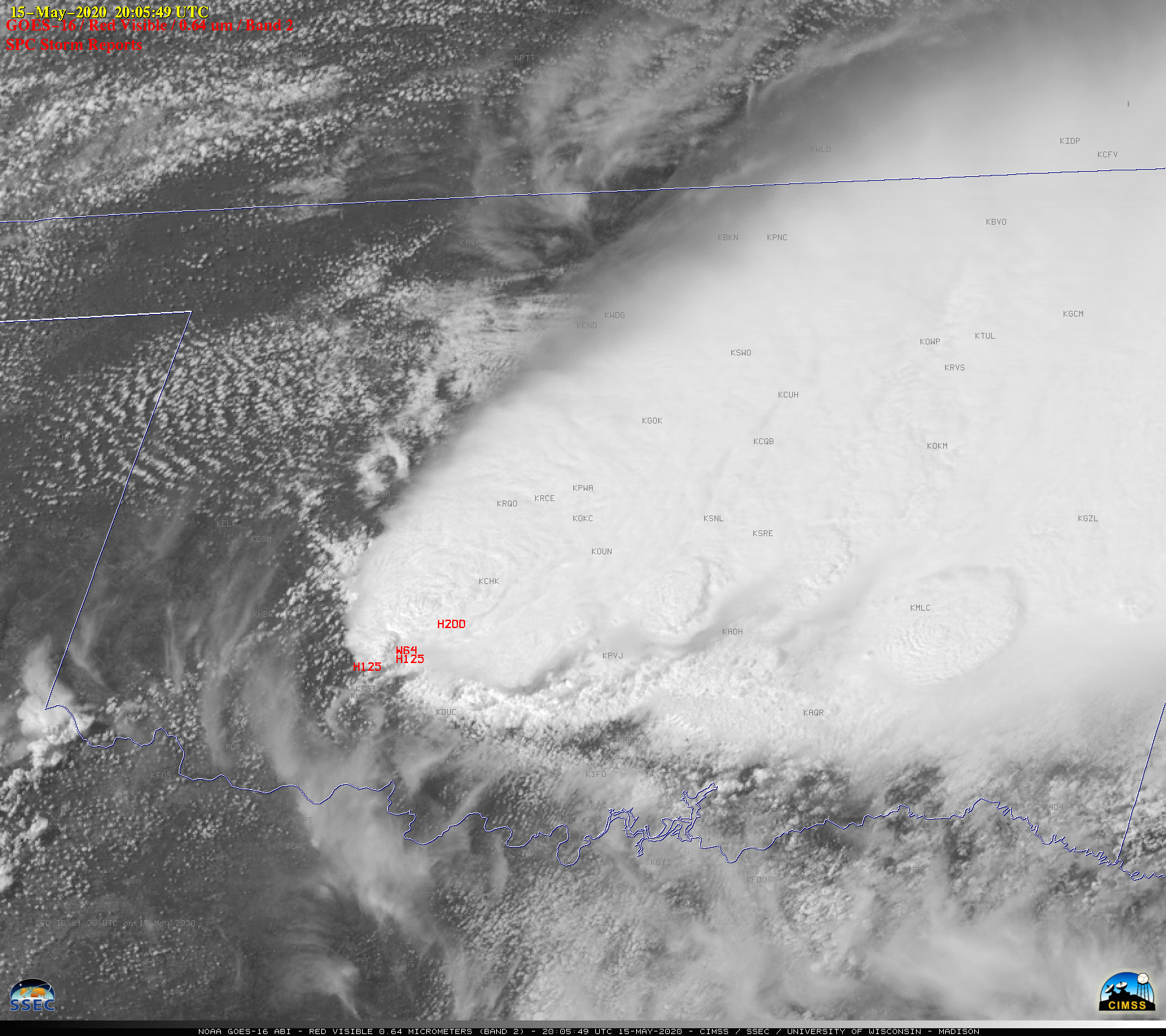
1-minute Mesoscale Domain Sector GOES-16 (GOES-East) “Red” Visible (0.64 µm) images with plots of time-matched SPC Storm Reports (above) showed back-building thunderstorms that propagated southwestward across Oklahoma on 15 May 2020.The corresponding GOES-16 “Clean” Infrared Window (10.35 µm) images (below) revealed pulsing overshooting tops that occasionally exhibited cloud-top infrared brightness temperatures as cold as -80ºC (violet pixels) toward... Read More

GOES-16

GOES-16 “Red” Visible (0.64 µm) images, with SPC Storm Reports plotted in red [click to play animation | MP4]

1-minute Mesoscale Domain Sector GOES-16 (GOES-East) “Red” Visible (0.64 µm) images with plots of time-matched SPC Storm Reports (above) showed back-building thunderstorms that propagated southwestward across Oklahoma on 15 May 2020.

The corresponding GOES-16 “Clean” Infrared Window (10.35 µm) images (below) revealed pulsing overshooting tops that occasionally exhibited cloud-top infrared brightness temperatures as cold as -80ºC (violet pixels) toward the end of the time period.

GOES-16 "Clean" Infrared Window (10.35 µm) images, with SPC Storm Reports plotted in cyan [click to play animation | MP4]

GOES-16 “Clean” Infrared Window (10.35 µm) images, with SPC Storm Reports plotted in cyan [click to play animation | MP4]

Plots of 12 UTC and 18 UTC rawinsonde data from Norman, Oklahoma (below) indicated that winds throughout the troposphere had a westerly to southerly component.

Plots of rawinsonde data from Norman, Oklahoma [click to enlarge]

Plots of rawinsonde data from Norman, Oklahoma [click to enlarge]

View only this post Read Less

A View of the Development of Geostationary Imagers through the lens of BAMS

https://cimss.ssec.wisc.edu/satellite-blog/wp-content/uploads/sites/5/2020/05/BAMS_Sat_covers2_1min.mp4A collection of 60 BAMS covers spanning the years, to highlight the rapid advance of imaging from the geostationary orbit, is shown above (a version that loops more slowly can be seen here). The first cover is the first of BAMS, in January of 1920, while the second, from... Read More

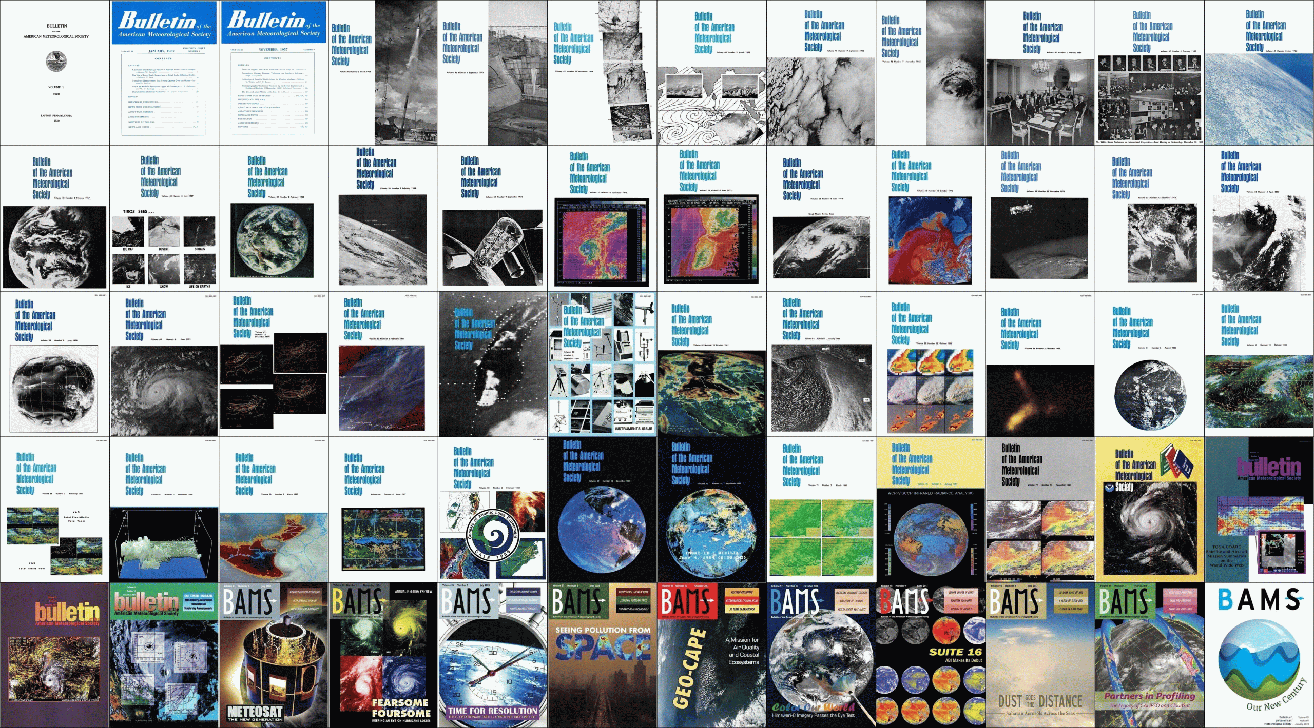
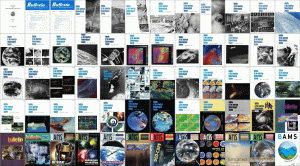
A collection of 60 BAMS covers spanning the years, to highlight the rapid advance of imaging from the geostationary orbit, is shown above (a version that loops more slowly can be seen here). The first cover is the first of BAMS, in January of 1920, while the second, from January of 1957 is the first time artificial ‘satellite’ was in a title of a BAMS article. The third image, from November of 1957, is a remarkable article on potential uses of satellites. This included both qualitative uses: (1) Clouds, (2) Cloud Movements, (3) Drift of Atmospheric Pollutants, (4) State of the Surface of the Sea (or of Large Lakes), (5) Visibility or Atmospheric Transparency to Light — and quantitative uses: (1) Albedo, (2) Temperature  of  a  Level  at  or  Near  the Tropopause, (3) Total Moisture Content., (4) Total  Ozone  Content, (5) Surface  (Ground-Air Interface) Temperature, and (6) Snow Cover. Early covers showcase rockets, balloons and high-altitude aircraft to prepare the way to human space travel (Gemini, Apollo, etc.), polar-orbiters (TIROS, NIMBUS, VHRR, NOAA, etc.) and finally geostationary orbit (ATS-1, ATS-3, SMS, GOES, Meteosat, INSAT, Himawari, etc.).

Reasons to look back at the BAMS covers:

Interactive web page, with links to the original “front matter”.

Montage of select BAMS covers

Montage of select BAMS covers

Note: All cover images are from the Bulletin of the American Meteorological Society.

View only this post Read Less