This website works best with a newer web browser such as Chrome, Firefox, Safari or Microsoft
Edge. Internet Explorer is not supported by this website.
The radiosonde profile from the balloon launch just before 0000 UTC 7 September, above, (imagery from the Wyoming Sounding site), shows a very moist airmass, with saturation from the surface up to 400 hPa, and relative dryess above that level. Total Precipitable Water was 63 mm.NOAA-20, NOAA-21 and Metop-C all provide NUCAPS (NOAA-Unique Combined Atmospheric... Read More
Rawinsonde at 0000 UTC 7 September 2024 (Click to enlarge); This balloon was released by your blogger!
The radiosonde profile from the balloon launch just before 0000 UTC 7 September, above, (imagery from the Wyoming Sounding site), shows a very moist airmass, with saturation from the surface up to 400 hPa, and relative dryess above that level. Total Precipitable Water was 63 mm.
NOAA-20, NOAA-21 and Metop-C all provide NUCAPS (NOAA-Unique Combined Atmospheric Processing System) profiles. The Metop-C overpasses near American Samoa at 1842 UTC on 6 September, shown below, include a series of four green points (that is, points where the infrared retrieval converged to a solution) in the westernmost column of profiles just east of the Samoan Islands. The NUCAPS profile below is similar to the observation from Tutuila: very moist (this one had a Precipitable Water value of more than 2″), and a dry region above 400 hPa. NUCAPS profiles can give useful thermodynamic information in regions where conventional data are missing.
NUCAPS Sounding Availability, 1842 UTC on 6 September 2024 (Click to enlarge)NUCAPS Profiles at 14 S, 168 W, 1954 UTC on 6 September 2024 (Click to enlarge)
At 0000 UTC on 9 September, the upper-air sounding, below (source), shows a much drier atmosphere. Note, for example, that Total Precipitable Water is 45.7mm on 9 September compared to 63mm on the 7th.
0000 UTC Rawinsonde at Pago Pago, American Samoa, 9 September 2024 (Click to enlarge)
The NUCAPS profile (from Metop-C), at 2054 UTC on 8 September, below, centered on Tutuila (the island on which Pago Pago sits) shows structures that are similar to the rawindsonde above, namely relatively moist from 500-300 mb with dryer air above and below. It is always important to remember that NUCAPS moisture resolution is about 4-6 layers in the troposphere.
NUCAPS profile over Pago Pago, 2053 UTC on 8 September 2024 (Click to enlarge)
Lightning dashboard for Bismarck Airport, North Dakota.
ProbSevere is a collection of nowcasting products for convective hazards. Two such products are LightningCast and IntenseStormNet, which are AI models that use solely satellite data to make predictions. LightningCast predicts the probability of lightning in the next 60 minutes, whereas IntenseStormNet detects the strongest portions of storms, which are likely to produce tornadoes, severe hail, and severe wind gusts. Both use data images from satellite instruments.
Last week, storms erupted on the South Dakota / North Dakota border within the warm sector of a surface low pressure system. The animation below shows the evolution of LightningCast (left) and IntenseStormNet (right) over time.
One important goal of LightningCast is provide actionable lead time to lightning initiation. Using GOES-16 GLM flash-extent density, we see that LightningCast provided about 30 minutes of lead time to the first flash in the southern cells, and then 25 minutes of lead time to the first flash in the later northern cell, when measured from the cyan 25% probability contour. As storms matured, we noticed how the probability contours were more packed to the west, the upstream side of the convection, whereas they were more diffuse in the downstream direction of convection (eastward). The diffuse nature of the eastward contours indicates less certainty on where lightning will be within the next hour, where the storm cores and associated anvil clouds were heading. We believe this is a signal that the LightningCast model learned the approximate motion of storms from a single timestamp of GOES-R ABI images. More research is underway using time sequences of images to see if that can improve implicit motion estimates and lightning predictions.
The northern cell in central North Dakota impacted Bismarck Airport. The lightning dashboard below shows how LightningCast probabilities from both GOES-East and GOES-West increased initially over the airport, then were fairly steady, and then rapidly increased over about 10-15 minutes before the first lightning strikes were detected within 5 miles of the airport by the both GOES-East and GOES-West GLM instruments. These dashboards, available to forecasters at airports, many stadiums, and over wildland fires, help to sync the LightningCast probability information and GLM-observed flashes with potentially vulnerable locations of interest, facilitating the National Weather Service’s decision support for key entities.
Looking again at the animation above, the IntenseStormNet uses images of 0.64-µm reflectance, 10.35-µm brightness temperature, and GLM flash-extent density to predict a probability of “intense” convection. The product really highlights the intense most regions, where strong overshooting tops and “cold-U” signatures reside, often colocated with robust “bubbly” texture from the visible reflectance. Notice the fact that many reported severe weather events werre associated with these features, created by the strong storm updrafts. Nearby pronounced anvil-edge gradients in the ABI channels and a core of GLM flash-extent density are also important features for contributing to higher probabilities.
IntenseStormNet output is a predictor in ProbSevere v3, machine-learning models that combine radar, satellite, lightning, and environmental data to predict the next-hour probability of severe hail, severe wind gusts, and tornadoes. IntenseStormNet can also be used as a stand-alone satellite-only severe-weather nowcasting tool in the absence of radar, such as in parts of the western U.S., in Canada, in oceanic regions, and in parts of Latin America.
LightningCast should be operational at NOAA/NESDIS in early 2025.
VIIRS data from NOAA-20 at the CIMSS Direct Broadcast download site, above, at 1734 UTC on 2 September were used to create True Color imagery, and SST fields over the largely-clear Great Lakes. Light winds associated with persistent high pressure over the Great Lakes (below) meant suppressed vertical mixing, leading to warm water temperatures on the... Read More
VIIRS data from NOAA-20 at the CIMSS Direct Broadcast download site, above, at 1734 UTC on 2 September were used to create True Color imagery, and SST fields over the largely-clear Great Lakes. Light winds associated with persistent high pressure over the Great Lakes (below) meant suppressed vertical mixing, leading to warm water temperatures on the lake surface. Most of Lake Superior’s surface is warmer than 60oF, with portions of Lake Erie, Saginaw Bay, and Green Bay near 77oF. This is also shown in the AWIPS Screen-capture with the same data, below.
Surface Analysis, 1500 UTC on 2 September 2024Lake Surface Temperatures and True Color Imagery derived from NOAA-20 (not NPP) VIIRS Data, 1733 UTC on 2 September 2024 (Click to enlarge); the cause for the data void over western Lake Superior is being investigated.
Early on 1 September, skies were also mostly clear, and the VIIRS ACSPO SSTs are shown below in concert with Day Night Band visible imagery. The warmest temperatures in the color enhancement (white) are 77oF (that is, 25oC).
VIIRS Day Night Band and ACSPO SSTs, 0753 UTC on 1 September 2024 (Click to enlarge)
Clear skies continued overnight on 2-3 September, and another beautiful scene was produced. Lake Surface Temperatures and the Day Night Band at 0740 UTC on 3 September are shown below.
VIIRS Day Night Band and ACSPO SSTs, 0740 UTC on 3 September 2024 (Click to enlarge)
True-Color imagery from VIIRS and Lake Surface Temperatures are shown below from 1834 UTC on 3 September. Note the complete coverage over western Lake Superior. The anomaly in the analysis above has been rectified. Smoke is also apparent in this image over northern WI and central MN.
Lake Surface Temperatures and True Color Imagery derived from VIIRS Data, 1833 UTC on 3 September 2024 (Click to enlarge);
The smoke shows up well in the VIIRS AOD field, below (and in the GOES-16 fields as well here)
VIIRS Aerosol Optical Depth, 1833 UTC on 3 September 2024 (Click to enlarge);
Nighttime Microphysics RGB Imagery (Quick Guide) from the CSPP Geosphere site, above (direct link to image), from early on 1 September, shows a distinct color change from the southern US to the northern US, stretching east-northeast from Oklahoma to Pennsylvania. This abrupt change from deep purple to light purple heralds a change in... Read More
Night Microphysics RGB imagery, 0701 UTC on 1 September 2024 (Click to enlarge)
Nighttime Microphysics RGB Imagery (Quick Guide) from the CSPP Geosphere site, above (direct link to image), from early on 1 September, shows a distinct color change from the southern US to the northern US, stretching east-northeast from Oklahoma to Pennsylvania. This abrupt change from deep purple to light purple heralds a change in moisture — as one might expect in early September as cooler, dryer air starts its inexorable move south as Summer wanes. The cyan color of low clouds is also present along this boundary (and in central Iowa). Part of the color change will be controlled by temperature as well: Blue in the RGB is a function of the Band 13 brightness temperature.
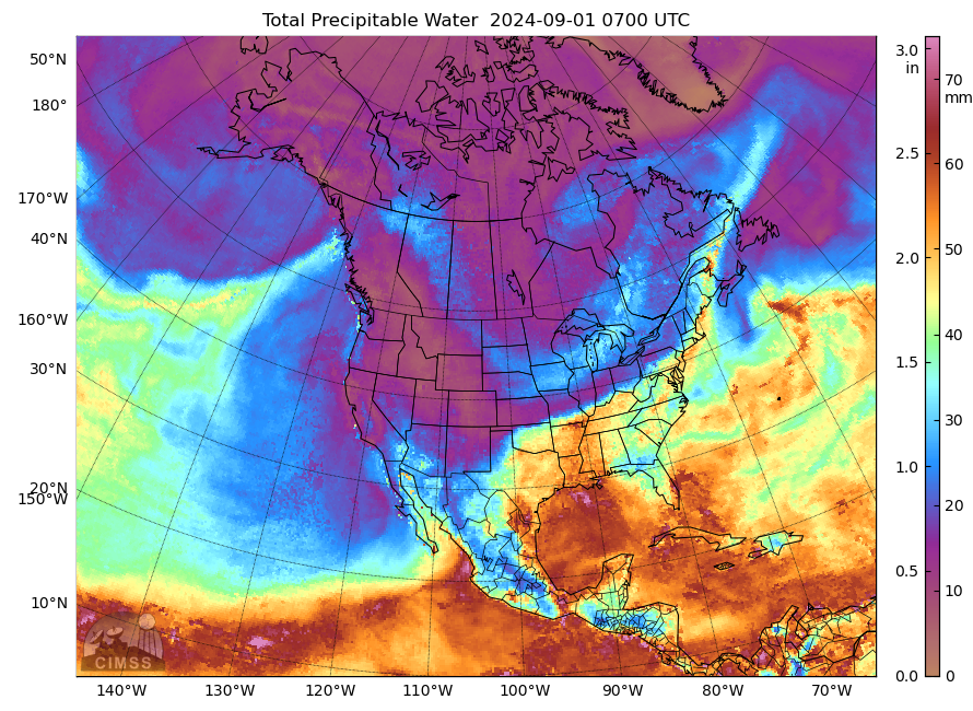
MIMIC Total Precipitable Water fields, above, from 0700 UTC, also show the sharp gradient in total precipitable water along this boundary as values drop from near 2″ over Arkansas to closer to 1/2″ over central Missouri. Blended TPW fields, below, taken from the CIRA SLIDER, show a similar sharp boundary.
Blended Total Precipitable Water Product, 0700 UTC on 1 September 2024 (Click to enlarge)
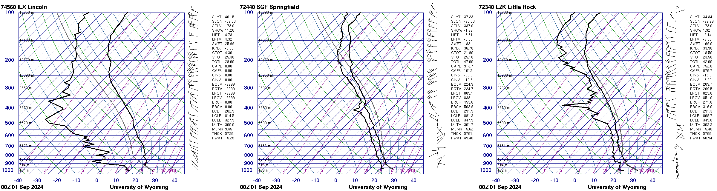
How did Precipitable Water (PWAT) change across this boundary in the 0000 UTC Soundings on 1 September? Skew-Ts, below (from the Wyoming Sounding site), from Lincoln IL (left, in the dry air), Springfield MO (center) and Little Rock AR (right), show PWAT values of 15, 49 and 51 mm, respectively!
0000 UTC Soundings from Lincoln IL (Left), Springfield MO (center) and Little Rock AR (right) on 1 September 2024 (Click to enlarge)
Hat tip to Jochen Kerkmann, EUMETSAT, for noting this event today and sending out an email.


