This website works best with a newer web browser such as Chrome, Firefox, Safari or Microsoft Edge. Internet Explorer is not supported by this website.

GOES-13: Images at 30-Second Intervals

On 12 December 2006 (Day 6 of the GOES-13 post-launch NOAA Science Test), the GOES-13 satellite was placed into Super Rapid Scan Operations (SRSO) mode, providing images at 30-second intervals for the entire day. A 200-image QuickTime animation of visible imagery (above) shows the development of convection along an advancing cold frontal boundary during the... Read More

GOES-13 visible images (QuickTime animation)
On 12 December 2006 (Day 6 of the GOES-13 post-launch NOAA Science Test), the GOES-13 satellite was placed into Super Rapid Scan Operations (SRSO) mode, providing images at 30-second intervals for the entire day. A 200-image QuickTime animation of visible imagery (above) shows the development of convection along an advancing cold frontal boundary during the late morning into the early afternoon hours; isolated severe thunderstorm warnings were issued for counties in eastern Mississippi (however, no reports of severe weather were received from these particular storms). Previous GOES satellites have provided 30-second interval imagery during special test periods (for example, GOES-8 in 1996), but such SRSO test periods were much shorter (about 10 minutes total duration).

A QuickTime animation of GOES-13 10.7µm IR images (below) reveals fairly cold cloud top temperatures (around -55 to -60 C, orange to red enhancement), but no “enhanced-v” signature was observed. A few cloud to ground (CG) lightning strikes were seen in the vicinity of the strongest convection, but flash rates were quite low (GOES-12, MODIS IR images with CG strikes).
GOES-13 IR images (QuickTime animation)

View only this post Read Less

GOES-13: Full Disk Images at 30-Minute Intervals

As a part of the GOES-13 post-launch NOAA Science Test, the satellite provided continuous “full disk” images every 30 minutes for 2 consecutive days (09-10 December 2006); the current operational GOES full disk imaging interval is only once every 3 hours, but the Advanced Baseline Imager on GOES-R will provide full disk scans every 15... Read More

GOES-13 full disk water vapor image
As a part of the GOES-13 post-launch NOAA Science Test, the satellite provided continuous “full disk” images every 30 minutes for 2 consecutive days (09-10 December 2006); the current operational GOES full disk imaging interval is only once every 3 hours, but the Advanced Baseline Imager on GOES-R will provide full disk scans every 15 minutes. GOES-13 6.5µm “water vapor channel” imagery (above) showed cloudiness as well as non-cloudy water vapor circulations within the middle troposphere (Java animation), while the visible channel (below) provided a view of cloud features during the daylight hours (Java animation).
GOES-13 full disk visible image

View only this post Read Less

GOES-13: Fire Activity in Arkansas

On 08 December 2006 (Day 2 of the GOES-13 post-launch NOAA Science Test), 3.9µm shortwave IR images from GOES-13 and GOES-12 (above) revealed several “hot spots” (black enhancement) due to fire activity (Read More

GOES-13, GOES-12 3.9µm IR images

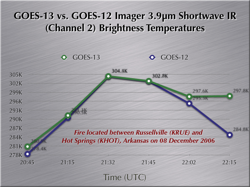
On 08 December 2006 (Day 2 of the GOES-13 post-launch NOAA Science Test), 3.9µm shortwave IR images from GOES-13 and GOES-12 (above) revealed several “hot spots” (black enhancement) due to fire activity (NOAA HMS) across parts of Arkansas (Java animation). The performance of the GOES-13 3.9µm IR channel was comparable to that of GOES-12 for this particular group of relatively small and short-lived fires — a plot of the GOES-13 vs GOES-12 shortwave IR brightness temperatures (below) for the fire that was located between Russellville (KRUE) and Hot Springs (KHOT) Arkansas showed similar values as that particular fire was reaching maximum size and intensity.
GOES-13 vs GOES-12 3.9µm temperature

View only this post Read Less

GOES-13: Detecting Surface Features in Water Vapor Channel Imagery

During Day 2 (08 December 2006) of the GOES-13 post-launch NOAA science test, a cold and dry air mass was moving eastward over the southern Great Lakes region; “water vapor channel” images from the GOES-13 and... Read More

GOES-13, GOES-12 water vapor images
During Day 2 (08 December 2006) of the GOES-13 post-launch NOAA science test, a cold and dry air mass was moving eastward over the southern Great Lakes region; “water vapor channel” images from the GOES-13 and GOES-12 imagers (above) displayed what appeared to be a typical pattern of 6.5µm brightness temperature values. However, a Java animation of the GOES-13 and GOES-12 water vapor channel images  (with the map overlay removed) shows the outline of the southern portion of Lake Michigan as the pocket of driest air moved across that area.

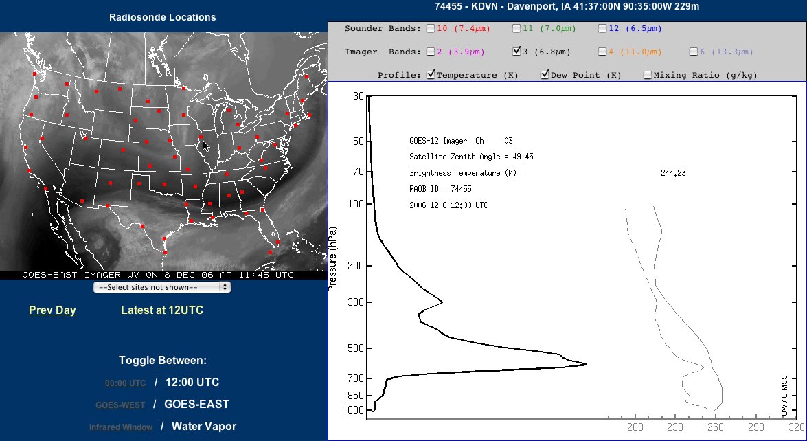
Detecting surface-based features (or geographical boundaries) on the 6.5µm GOES imager water vapor channel is somewhat unusual, since the radiation sensed by that channel normally originates from the middle troposphere (generally from within the 500-300 hPa layer, or 5-9 km above the surface in a US Standard Atmosphere). However, on this particular day, the air mass located over the Upper Midwest region was rather cold and dry — the GOES-12 water vapor weighting function calculated using the rawinsonde data from Davenport, Iowa at 12 UTC on 08 December (below) indicates that a significant contribution to the water vapor channel radiance at that location was coming from altitudes as low as the 600-700 hPa layer. The warm waters of Lake Michigan were surrounded by relatively cold land surfaces (GOES-13 10.7µm IR image with surface temperature reports), and a signal from this strong thermal contrast was bleeding up through what little water vapor was present within the atmospheric column, allowing the outline of Lake Michigan to be detected on the GOES-12 and GOES-13 water vapor channel imagery.
Davenport, IA water vapor weighting function

View only this post Read Less