This website works best with a newer web browser such as Chrome, Firefox, Safari or Microsoft Edge. Internet Explorer is not supported by this website.

Ice storm in southeastern Kansas and southern Missouri

A significant ice storm affected parts of extreme southeastern Kansas and southern Missouri on 1112 February 2008, leaving an accrual of ice more than 1 inch thick in parts of Missouri. AWIPS images of the visible and 1.6µm near-IR “snow/ice” channels (above) revealed the extent of the coverage of snow and ice that remained a day later on 13 February 2008. Note the very dark... Read More

MODIS visible + snow/ice images (Animated GIF)

A significant ice storm affected parts of extreme southeastern Kansas and southern Missouri on 1112 February 2008, leaving an accrual of ice more than 1 inch thick in parts of Missouri. AWIPS images of the visible and 1.6µm near-IR “snow/ice” channels (above) revealed the extent of the coverage of snow and ice that remained a day later on 13 February 2008. Note the very dark signal on the snow/ice channel image in Kansas/Missouri — even though there was much less snow cover there (1-5 inches) compared to areas farther north in eastern Iowa (where there was as much as 12-17 inches of snow on the ground), the fact that much of the affected portions of southeastern Kansas and southern Missouri were also coated with a thick layer of ice made that region exhibit a much stronger (and therefore darker) “snow/ice absorption signal”. In contrast to the darker snow/ice cover, supercooled water droplet clouds appear much brighter on the MODIS snow/ice channel image.

A slightly closer view using AWIPS images of the MODIS Land Surface Temperature (LST) and MODIS snow/ice channel images (below) showed that LST values were about 10º F colder (darker green enhancement) in the swath of snow/ice compared to the surrounding bare ground areas. Note that the “cloud mask” employed by the LST product does tend to produce some false cloud features (black pixels) in portions of the image where large gradients exist (for example, along the northern edge of the snow/ice swath).

MODIS land surface temperature + snow/ice images (Animated GIF)

A MODIS true color image of the area (below, viewed using Google Earth) shows that the snow/ice storm affected a good deal of the Interstate 44 corridor in southern Missouri (between Tulsa, Oklahoma and Saint Louis, Missouri).

MODIS true color image (Google Earth)

View only this post Read Less
Ice in southern Lake Michigan

A comparison of Terra and Aqua MODIS true color images on 13 February 2008 (above) shows that thick ice had formed along the nearshore waters of southwestern Lake Michigan; cold arctic air over the region a few days earlier (the daily maximum/minimum temperatures at Chicago O’Hare on 10 February were +1ºF/-4ºF) led... Read More

MODIS true color images (Animated GIF)

A comparison of Terra and Aqua MODIS true color images on 13 February 2008 (above) shows that thick ice had formed along the nearshore waters of southwestern Lake Michigan; cold arctic air over the region a few days earlier (the daily maximum/minimum temperatures at Chicago O’Hare on 10 February were +1ºF/-4ºF) led to an increase in thickness and areal coverage of lake ice along the coasts of Wisconsin, Illinois, and Indiana. The times of the 2 MODIS images above were about 111 minutes apart — Terra at 17:29 UTC (11:29am local time) Aqua at 19:10 UTC (1:10pm local time) — and they reveal that large segments of the lake ice were drifting eastward during that short time interval. Note the bright white appearance of the land surfaces, due to widespread deep snow cover (which ranged from about 5-6 inches in the Chicago metro area to 24 inches at Janesville in southern Wisconsin). Slightly darker portions of the visible image are due to a higher density of trees (especially in urban areas, and also along river valleys) — a very low tree density exists in the majority of this particular region due to agricultural land use in the rural areas.

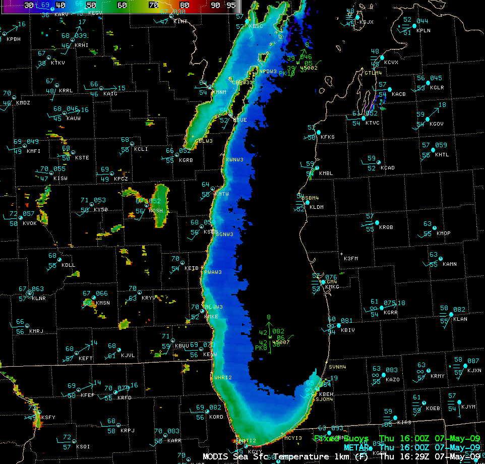
Surface METAR and buoy data plotted on an AWIPS image combination of the MODIS visible channel + the MODIS Sea Surface Temperature (SST) product (below) indicated that surface winds were west-southwesterly at around 10 knots during that time, no doubt aiding the eastward drift of the lake ice; SST values in the ice-free waters of southern Lake Michigan were quite cold, ranging from 33º to 39º F (dark blue to light blue enhancement).

MODIS visible + sea surface temperature image

View only this post Read Less
Madison sets a new record for total winter season snowfall

The previous all-time record for total winter season snowfall in Madison, Wisconsin was 76.1 inches (set in 1978/1979); however, the winter of 2007/2008 decided that would be an easy record to break…and on the morning of 12 February 2008, the old winter season record was finally eclipsed by 1.8 inches of fluffy... Read More

GOES-12 6.5µm water vapor images (Animated GIF)

The previous all-time record for total winter season snowfall in Madison, Wisconsin was 76.1 inches (set in 1978/1979); however, the winter of 2007/2008 decided that would be an easy record to break…and on the morning of 12 February 2008, the old winter season record was finally eclipsed by 1.8 inches of fluffy snowfall. Not content to stop there, the atmosphere conjured up another round of snowfall later in the day, courtesy of a potential vorticity (PV) anomaly that propagated eastward from eastern Iowa into northern Illinois and southern Wisconsin.

AWIPS images of the GOES-12 6.5µm “water vapor” channel (above) showed a warm/dry signature (darker blue enhancement) associated with the core of the PV anomaly — the “dynamic tropopause” (taken to be the pressure of the 1.5 Potential Vorticity Unit surface) was extruded downward to as low as about the 500 hPa pressure level early in the day. PV anomalies tend to induce upward vertical motions as they approach a given area, and in this case the approaching PV anomaly helped to generate another band of moderate snowfall in southcentral Wisconsin, as seen by the radar reflectivites (below) greater than 20 dBz (green enhancement) that added another 2.0 inches to Madison’s ever-growing winter season snowfall total.

Radar base reflectivity (Animated GIF)

An AWIPS image combination of the GOES-12 water vapor imagery (with a different color enhancement) plus the radar base reflectivity is shown below.

GOES water vapor + radar reflectivity (Animated GIF)

View only this post Read Less

Aircraft contrails over the Upper Midwest

Comparing AWIPS images of the MODIS visible channel, 11.0µm “IR window” channel, 3.7µm “shortwave IR” channel, and 1.6µm near-IR “cirrus channel” (above) showed how certain satellite channels are very useful in the detection of a broad area of aircraft contrails that existed over parts of Illinois, Indiana, and lower Michigan... Read More

MODIS images (Animated GIF)

Comparing AWIPS images of the MODIS visible channel, 11.0µm “IR window” channel, 3.7µm “shortwave IR” channel, and 1.6µm near-IR “cirrus channel” (above) showed how certain satellite channels are very useful in the detection of a broad area of aircraft contrails that existed over parts of Illinois, Indiana, and lower Michigan (likely resulting primarily from air traffic to/from Chicago and Detroit) on the morning of 12 February 2008. The 3.7µm shortwave IR and the 1.6µm cirrus channels offered the best depiction of the actual areal coverage of these contrails; the contrail features exhibited a slightly darker signal on the shortwave IR image (due to the smaller ice particle size of the contrails compared to the surrounding cirrus clouds), while they appeared slightly brighter in the cirrus image (since the smaller particles comprising the contrails were better scatterers than those comprising the surrounding cirrus clouds).

Examining other satellite products such as the MODIS Cloud Phase product, MODIS Cloud Top Temperature product, and the GOES sounder Cloud Top Height product (below) from that same time period confirmed that these aircraft contrails existed in an environment that consisted primarily of ice phase clouds (light red enhancement) which exhibited rather cold MODIS cloud top temperatures (-40º to -60º C, cyan to dark blue enhancement) and fairly high GOES sounder cloud top height values (30,000-39,000 feet above ground level, light blue to white enhancement).

MODIS + GOES sounder images (Animated GIF)

View only this post Read Less