This website works best with a newer web browser such as Chrome, Firefox, Safari or Microsoft Edge. Internet Explorer is not supported by this website.

Archive: Mon Nov 2023

Iceberg A23a in the Antarctic Ocean

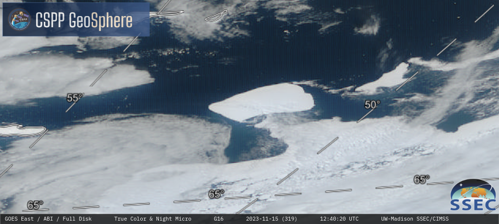
10-minute interval GOES-16 (GOES-East) True Color RGB images (source) from 0930-1900 UTC on 13-26 November 2023 (above) showed Iceberg A23a just east-northeast of Joinville Island (at the tip of the Antarctic Peninsula). Although cloud-free periods were scarce during those 14 days, even on most of the cloudy days the silhouette... Read More

Lake Erie lake effect snow band produces thundersnow in western New York

1-minute Mesoscale Domain Sector GOES-16 (GOES-East) Day Cloud Phase Distinction RGB images with an overlay of GLM Flash Extent Density (above) showed a glaciating (brighter shades of green) to glaciated (pale shades of yellow) lake effect snow (LES) band streaming inland off Lake Erie on 17 November 2023. There were 4 brief periods of lightning activity seen just south of the Buffalo,... Read More

Assessing fire and smoke in Louisiana with RealEarth

GOES-East fire detection products in RealEarth allow users to assess burning areas across the Continental United States. In the example below, burning appears to be occurring in Lafayette Parish, Louisiana. These fire detections in southern Louisiana are picked up by the GOES scene fire detection and by the GOES fire... Read More

Using CSPP’s polar2grid to create mappings of sea-surface temperature

The Community Satellite Processing Package (CSPP) allows a user to manipulate VIIRS data to create high-quality, full-resolution imagery (see, for example, this I05 example, and this Day Night Band example, and this I01 example). In addition to single-band images, imagery for products such as Advanced Clear Sky Processor for Ocean (ACSPO) sea-surface temperatures (SSTs) can also be created, as shown above. Polar2grid software... Read More