GOES-14 Visible (0.63 µm) images, with hourly surface reports and SPC storm reports of hail (yellow) and damaging winds (cyan) [click to play MP4 animation]
GOES-14 SRSO-R: severe thunderstorms over North Dakota, South Dakota and Minnesota
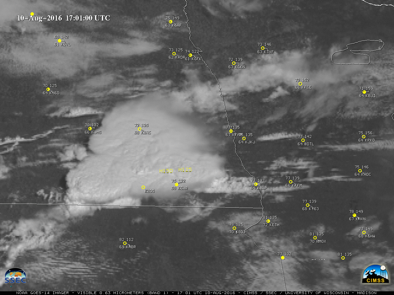
August 10th, 2016 | Scott BachmeierGOES-14 is operating in SRSO-R Mode
August 9th, 2016 | Scott LindstromShown below is a comparison of GOES-15 (GOES-West), GOES-14 and GOES-13 (GOES-East) Visible images covering the longer 1-hour period of 1230-1330 UTC, focusing on a area of thunderstorms over North Texas. During this time, there are 53 images from GOES-14, compared to 7 images from GOES-15 and 5 images from GOES-13 — note how the evolution of overshooting tops is very easy to follow using the 1-minute GOES-14 imagery.
GOES-14 also monitored the dissipation of fog/low stratus clouds over Nebraska, as seen in the animation below. Additional details can be found here. Later in the day, the GOES-14 Visible (0.62 µm) animation below (also available as a large 62 Mbyte animated GIF) showed the development of severe thunderstorms in Montana and Wyoming, which produced several reports of damaging winds and large hail (up to 4.0 inches in diameter). This example is particularly noteworthy due to the fact that the storm was well-sampled by satellite imagery in a region of poor radar coverage (h/t to @DanLindsey77). For additional details on this case, see the VISIT Meteorological Interpretation Blog.GOES-14 Visible (0.62 µm) images, with surface reports and SPC storm reports of hail (yellow) and wind (cyan) [click to play MP4 animation]
Hurricane Earl makes landfall in Belize
August 4th, 2016 | Scott LindstromGOES-14 10.7 µm Infrared Window images, hourly from 0115 through 1015 UTC on 4 August 2016 [click to play animation]
Hurricane Earl made landfall around 0600 UTC on 4 August in Belize. The hourly animation from GOES-14, above, shows a rapid warming of the coldest cloud tops over Earl after landfall, as commonly happens. GOES-14 is out of storage to support SRSO-R Operations beginning Tuesday August 9.
The GOES-14 image at landfall shows coldest cloud tops on the north side of the storm. A timely Metop-A overpass (times available at this site) from several hours before landfall provided ASCAT winds, below, that also show strongest winds to the north side of this storm.
Although the strong winds of Earl have diminished now that the storm is over land, Total Precipitable Water values, below, (showing MIRS data, available at this site) remain high and flooding continues to be a threat. Earl is forecast to move along the southern tip of the Bay Campeche starting tomorrow. For more details see the National Hurricane Center website. Three geostationary satellites viewed Earl as it moved across the southern Yucatan peninsula. GOES-15, GOES-14 and GOES-13 visible imagery from near 1200 UTC is shown below. Two Geostationary Satellites viewing a system approximately equidistant from both satellites allowed for stereoscopic imagery to be created, below.GOES-14 is out of Storage
August 1st, 2016 | Scott LindstromGOES-14 has again been reactivated, and is distributing data from its location over the Equator at 105 W. GOES-14 will be entering SRSO-R mode next week, starting on 9 August (link) and continuing through 26 August.
Short animations of GOES-14 Visible (0.63 um) and Infrared Window (10.7 um) imagery are shown below.
A 3-panel comparison, below, shows Idaho/Montana wildfire smoke plumes as viewed from GOES-15 (GOES-West), GOES-14 and GOES-13 (GOES-East). The images are displayed in the native projection of each satellite.