This website works best with a newer web browser such as Chrome, Firefox, Safari or Microsoft Edge. Internet Explorer is not supported by this website.

Category: GOES-17

Pyrocumulonimbus cloud produced by the Bootleg Fire in Oregon

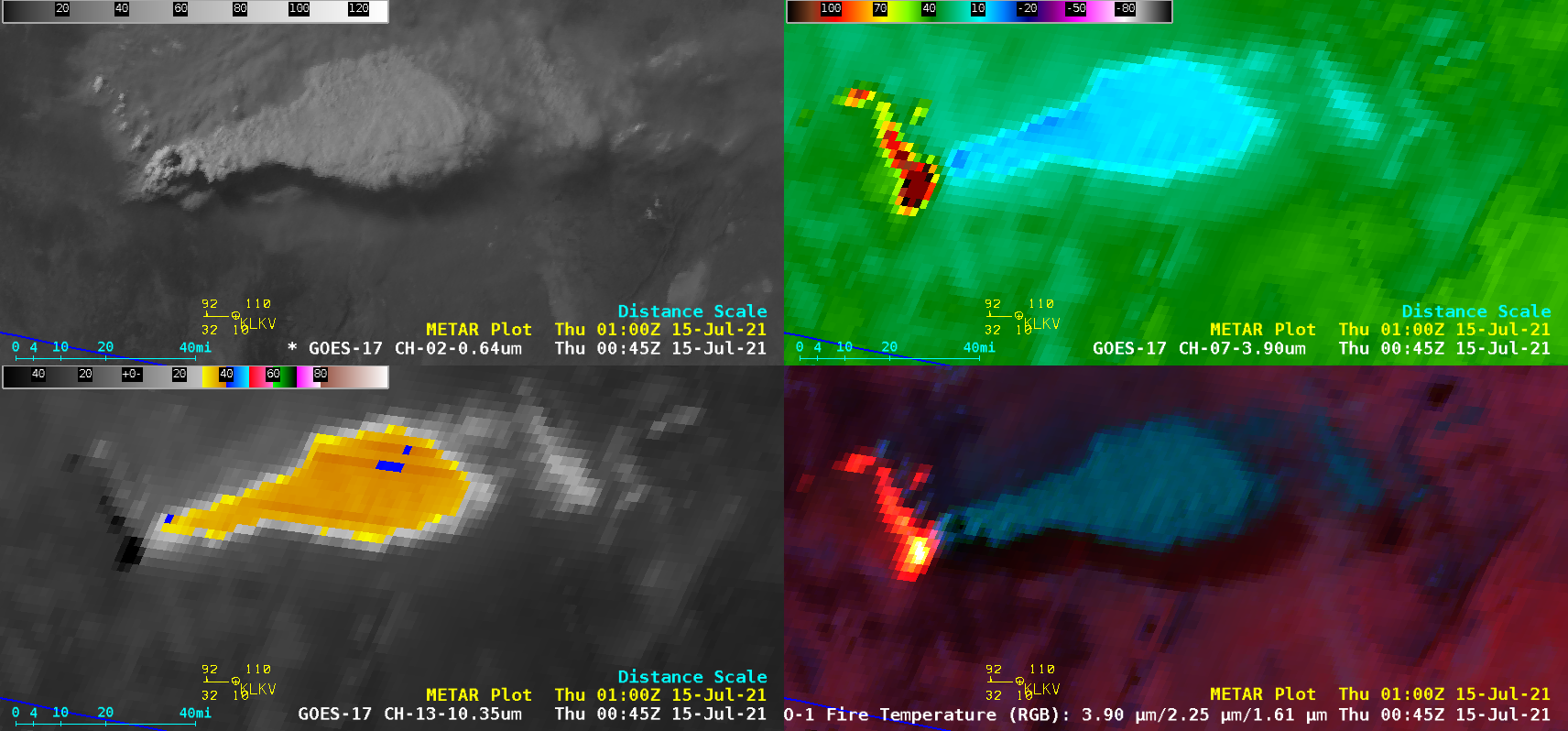
1-minute Mesoscale Domain Sector GOES-17 (GOES-West) “Red” Visible (0.64 µm), Shortwave Infrared (3.9 µm), “Clean” Infrared Window (10.35 µm) and Fire Temperature RGB images (above) revealed that the Bootleg Fire in far southern Oregon produced a pyrocumulonimbus (pyroCb) cloud — denoted by cloud-top 10.35 µm infrared brightness temperatures of -40ºC and colder (darker blue pixels) — late in the day... Read More

Creating RGB imagery using SIFT and Geo2Grid

The use of routine multispectral geostationary satellite imagery over the United States has increased the routine use of Red/Green/Blue composite imagery to describe and evaluate surface and atmospheric conditions. This blog post will detail how to create new (or old) RGB composites using two UW-Madison/CIMSS/SSEC-developed tools: The Satellite Information and... Read More

Pyrocumulonimbus clouds over British Columbia and California

GOES-17 (GOES-West) “Red” Visible (0.64 µm), Shortwave Infrared (3.9 µm) and “Clean” Infrared Window (10.35 µm) images (above) showed the explosive formation of large pyrocumulonimbus (pyroCb) clouds that were spawned by large wildfires in British Columbia, Canada on 30 June 2021. The 10.35 µm cloud-top infrared brightness temperatures rapidly cooled to the -50 to -60ºC range,... Read More

Strong winds from SAR over the South Pacific

The animation above shows convection over the south Pacific to the east of American Samoa (note the Manu’a Islands just east of 170 W Longitude in the animation). Extensive cloud cover will limit the ability of the GOES-17 instrument to detect low-level cloud motions underneath the deep convection, which motions... Read More