Land Breeze Over Western Lake Michigan
Long-time residents of the Great Lakes region know the significant impact that the lakes can have on the local weather. One of the most familiar effects is the lake breeze. Because it takes a long time for the lakes to warm up after winter while the land heats up comparatively quickly, during the spring and early summer the lakes are much cooler than the surrounding land. This creates a density gradient which forces a baroclinic circulation, resulting in a cool breeze blowing from the lake to the land.
However, in the fall the opposite can happen. Just as it takes the lakes a long time to warm up in the spring, it takes a long time for them to cool down in the fall. At the same time, the land cools off quickly, especially at night. This creates a similar gradient as the springtime lake breeze, but this time the gradient is reversed. As a result, an offshore flow of cool air flows toward the lake.
An example of this can be seen in the GOES-19 satellite imagery over Lake Michigan on the morning of October 30 2025. Overnight, the outer edges of a midlatitude cyclone centered over the southeast continental United States pushed moisture and cloudiness westward across Lake Michigan. Earlier in the evening, the eastward motion was able to propagate unabated cross the lake and into Wisconsin. However, as the night grew longer, the land breeze developed and served as a counterbalancing force, creating an edge to the cloudiness that persisted until sunrise.
The following animation shows this process in detail. It begins at 2130 UTC (3:30 PM local time) on the 29th and depicts both the GOES-19 Band 13 (10.3 micron) brightness temperature and the surface weather observations. Given the fact that this event transitions from day to night and back to day again, looking at a single-channel infrared loop allows us to use the same product for the entire period. A visible product is not usable at night, and many RGB products rely on shortwave channels and thus cannot be easily interpreted for both day and night scenes.
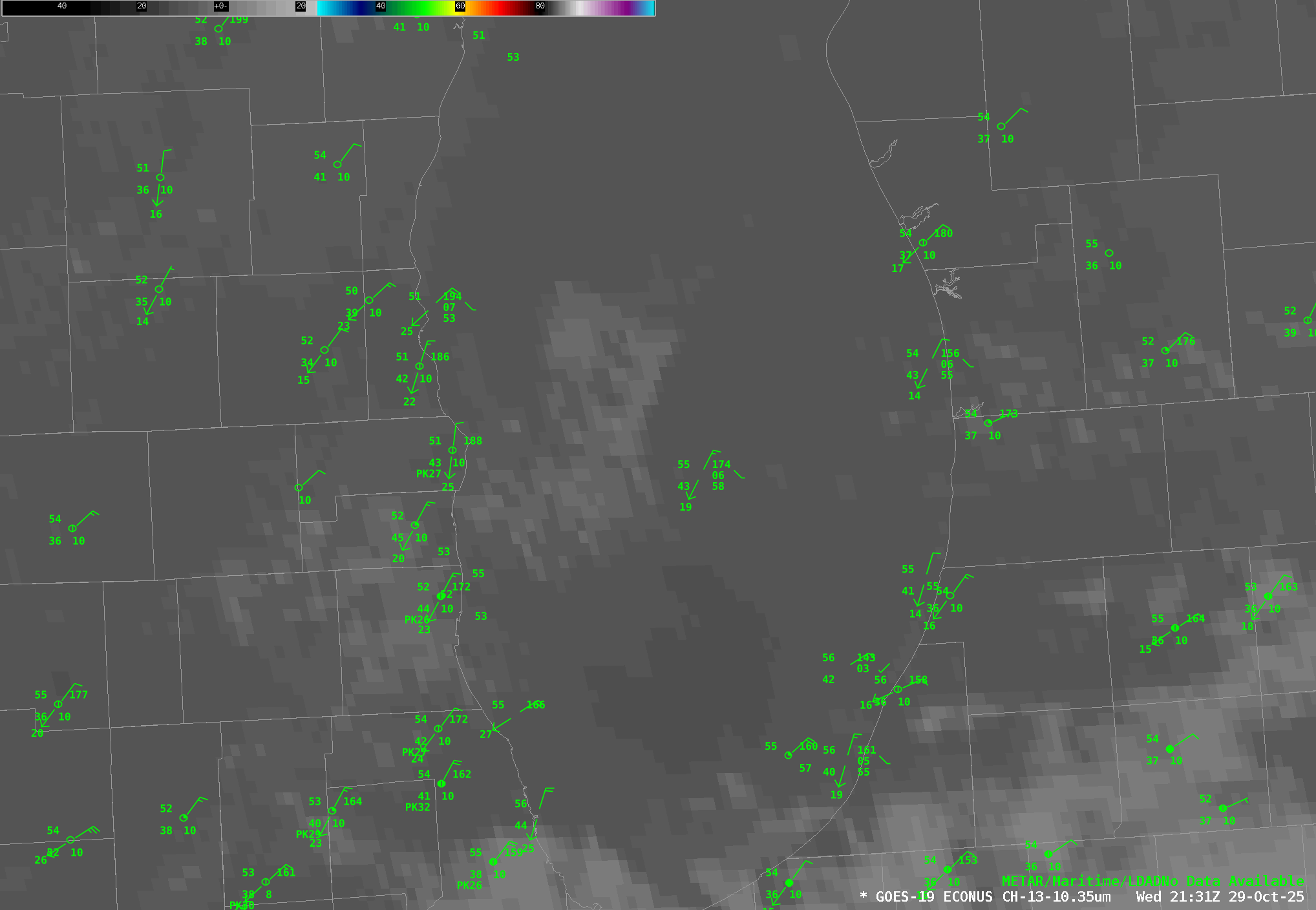
Note that at the beginning of the loop, the air temperature recorded by the buoy in the middle of the lake is not that different from the air temperatures from sites in western Wisconsin. At 0230 UTC (9:30 PM local time) the central lake buoy records an air temperature of 54 F with a northeasterly wind. Racine, Wisconsin, shows an air temperature of 52 F at the same time, with the same northeasterly wind. However, as the sun sets, the temperature difference grows as the night continues. By 0530 UTC (12:30 AM local time) the situation has significantly changed. The buoy is in a location with very little nocturnal cooling: it has drooped one degree to 51 F. However, Racine has cooled substantially and is now reporting a temperature of 45 F. Furthermore, the buoy wind is still northeasterly while the wind at Racine is now northwesterly. This flip in the wind direction indicates that the land breeze has formed.
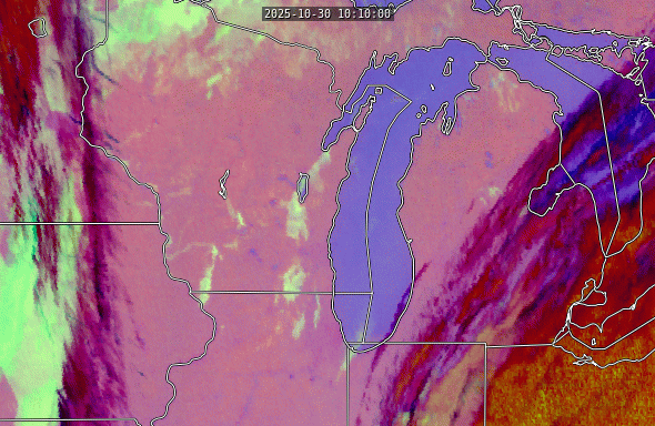
At 10 UTC the temperature gradient has gotten even stronger: 50 F for the lake air and 40 F for the terrestrial air, and by 1100 UTC (6:00 AM local time) the lake breeze is visible on the satellite as an edge to the cloudiness over the lake running roughly parallel to the lake’s western shore. Cloud were forming over the lake as the relatively warm and moist lake surface was able to create convection in the cooler air lying higher up. However, the advancing land breeze stabilized the air and inhibited convection where it advanced. This boundary is clearly visible on the night microphysics RGB. (Note also the large regions of fog throughout many parts of Wisconsin. These are identifiable as the areas of light green. The valley fogs forming in the river valleys of western Wisconsin are particularly notable).
As the sun rises, however, the temperature gradient breaks down. The land near the shore is able to heat up much more quickly than the lake is. By 1400 UTC (9:00 AM local time) the lake is only 6 degrees warmer than the land stations. The larger-scale synoptic winds are able to overcome the land breeze and push the clouds ashore. This animation from CSPP Geosphere shows the night to day transition.
Note that the land breeze front is better maintained in the northern part of the lake. There are a couple of reasons for this. First, it is colder up there. Overnight, terrestrial air temperatures dropped to the mid 30s F while the lake air temperatures remained around 50 F. Second, the presence of fog near shore means that less solar energy is available to change the temperature of the land due to reflection and latent heating. Thus, the gradient persists longer and the lake breeze is still able to inhibit convection over the western part of Lake Michigan.