A Lake Breeze and a Foggy Night in Chicago
Tens of thousands of baseball fans took to Chicago’s North Side on the evening of 14 May 2025 to watch a Major League Baseball game between the Miami Marlins and the Chicago Cubs. Fans of the Cubs might not remember much about the game itself (the Marlins won 3–1 with all runs on both teams scored via solo home runs) but it might be a while before thy forget the weather. A fog began to envelop the friendly confines of Wrigley Field early in the game, and it continued until well after the last out was recorded.
GOES-19 was well situated to capture the development and evolution of this fog event. The fog formation and propagation straddled the transition from day to night, and thus different products are necessary to best assess what happened since GOES ABI channels like Band 7 (3.9 microns) have drastically different interpretations depending on the time of day. During the day, Band 7 is largely capturing shortwave reflection from the sun which reduces its quantitative value for daytime cloud products. However, at night the same band represents thermal emission. Not only that, but the emission at that wavelength is a function of cloud phase and particle size. The embedded movie from CSPP Geosphere shows the transition from day to night and the switch from a true color RGB to the Night Microphysics RGB. (You can adjust the playback speed by clicking on the three dots in the lower right corner).
At the start of this loop, in the late afternoon, strong evidence of a lake breeze can be found. There is substantial clearing in eastern Wisconsin, northeastern Illinois, and northwestern Indiana with the boundary between the cloudy and clear regions largely paralleling the shore of Lake Michigan. The effect of the lake breeze is even more readily apparent if one looks at the evolution of the cloud field throughout the day via the GOES-19 True Color RGB.
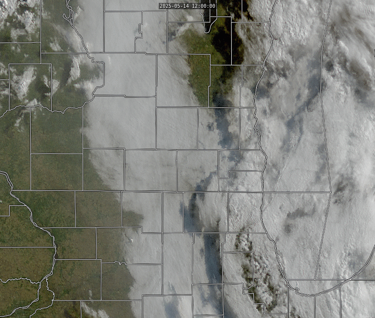
As the wind shifts to easterly flow, it brings a shallow layer of cold air ashore. This cold air is much more stable than the air it is replacing, and is often less moist too even though it originated over a vast lake. This is because the lake air is so much cooler than the land air that the absolute humidity levels are lower (even though the relative humidity levels are higher). The combination of cold, stable, and comparatively dry air kills off any convection that was taking place, so as the lake breeze propagates outward, it can easily be followed via satellite. Eagle-eyed readers might also notice that other, much smaller lakes in the area were also inhibiting convective development, including Lake Winnebago in the far upper part of the animation as well as the four lakes that characterize Madison, Wisconsin, in the middle left.
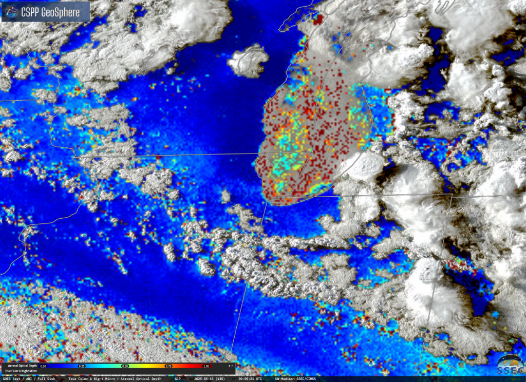
A quick visual inspection shows that the air quality of the existing airmass was much worse than the lake air that replaced it, too. A milky white pervades the regions away from Lake Michigan due to the enhanced shortwave scattering brought on by the high aerosol content; region closer to the lake are much more clear. The GOES Aerosol Optical Depth product confirms this, with notably higher aerosol optical depths further away from the shore; note the deep blues in eastern Wisconsin and northwestern Illinois with lighter blues further inland.
This persistent easterly flow was critical for what happened next. Air temperatures over the lake continued to fall, and thus reached the point of saturation. GOES-19 captured this perfectly as a filling in of the clouds over the lake, and only over the lake. Note that this was contemporaneous with sunset, so the animation segues from the daytime true color based on visible and near-infrared channels to the nighttime product which depends on longer wavelength channels.
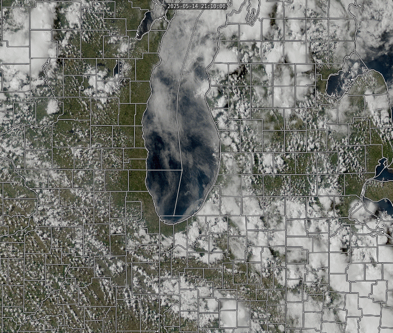
The easterly flow persisted, however, and pushed the low-level foggy air ashore. The Night Microphyscis product clearly shows the extent of the fogginess. While it only benetrated slightly into Illinois, much of western Wisconsin experienced notable fog.
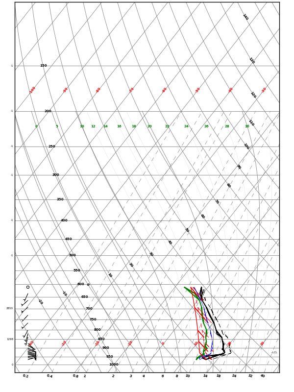
The shallowness of the fog layer is readily apparent from aircraft soundings. Over 100 commercial aircraft in the continental United States are equipped with temperature and water vapor sensors. Southwest Airlines is a major participant in this program, and with Chicago Midway being one of their most significant airports, there are several of these soundings every day. The Skew-T from 0208 UTC (9:08 local time) shows that the saturated later is only a few tens of millibars thick; above that, the air is too dry to support broad cloud formation in the absence of daytime convection. This image was obtained from Casey Webster’s wxster.com. Profiles from all over the continental United States using this publicly-available data source can also be found at that site and can be quite useful to help fill in the spatiotemporal gaps of the operational radiosonde network.
To see just how foggy it was, check out the highlights of the bottom of the 9th inning for the Cubs/Marlins game. You can see Major League Baseball’s video here.