Tropical Storm Gabrielle: tropical moisture, the Gulf Stream, and continental pollution
")
![]()
The poleward surge of elevated Total Precipitable Water (TPW) values (50-65 mm, orange to red enhancement) associated with Tropical Storm Gabrielle could be clearly seen on an animation of MIMIC TPW covering the 48-hour period from 09 to 10 September 2007 (above). Note that toward the end of the animation on 10 September, a plume of dry continental air (TPW values of 30-40 mm, blue to cyan enhancement) was entrained into the circulation of downgraded Tropical Depression Gabrielle as the cyclone moved away from the US East Coast.
As Gabrielle began to move northeastward across the Atlantic Ocean, it traveled along the north wall of the Gulf Stream — the warm waters in that region likely helped to prolong Gabrielle’s duration at tropical depression intensity. An 8-day composite of MODIS Sea Surface Temperature (SST) data (below) revealed that water temperatures along the axis of the Gulf Stream were still as warm as 83º F (28ºC) during early September.

==============================================
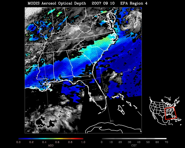
The IDEA MODIS Aerosol Optical Depth (AOD) product (above) indicated that the “dry air plume” moving eastward off the US coast also contained elevated levels of particle pollution, which was supported by the large number of surface AirNOW sites (below) from Georgia to North Carolina that reported “Moderate” concentrations of particle pollution (51-100 µg per cubic meter, yellow circles).
