Super Cyclone Gonu
Super Cylone 02A (“Gonu”) intensified rapidly in the Arabian Sea on 03-04 June 2007. EUMETSAT Meteosat-7 InfraRed imagery (above; animated GIF) showed very cold cloud-top IR brightness temperature values (-80º to -88º C, violet to purple enhancement) in the eyewall region during much of the 2-day period. A distinct eye was apparent on the Meteosat-7 IR images, as well as on the Meteosat-7 visible images on 04 June (animated GIF).
An overpass of the NOAA-17 satellite occurred at 17:33 UTC on 04 June; the IR image (below) depicted a detailed radial “banded structure” to the cold brightness temperature field, with a minimum temperature of -89º C (darker purple enhancement). Also note the area of concentric gravity waves south of the eye (within the gray-to-white enhanced area of -75º to -79º C brightness temperatures).
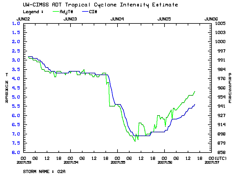
The CIMSS Advanced Dvorak Technique is a satellite-based method of estimating tropical cyclone intensity; the ADT plot (below) indicates that Gonu intensified very rapidly from late in the day on 03 June (day 2007154) to early in the day on 04 June (day 2007155), reaching Category 5 intensity (with 140 knot wind speeds). This was the first tropical cyclone of Category 5 strength on record in the Arabian Sea.


