Chemtool facility fire in Rockton, Illinois
![GOES-16 "Red Visible (0.64 µm, top left), Shortwave Infrared (3.9 µm, top right), Fire Power (bottom left) and Fire Temperature (bottom right) [click to play animation | MP4]](https://cimss.ssec.wisc.edu/satellite-blog/images/2021/06/210614_goes16_visible_shortwaveInfrared_firePower_fireTemperature_IL_chemical_plant_fire_anim.gif)
GOES-16 “Red” Visible (0.64 µm, top left), Shortwave Infrared (3.9 µm, top right), Fire Power (bottom left) and Fire Temperature (bottom right) [click to play animation | MP4]
However, a comparison of Shortwave Infrared images from GOES-17 (GOES-West) and GOES-16 (below) revealed that the western satellite’s viewing angle allowed the thermal anomaly of the fire source (hot black-enhanced pixel) to be seen for a longer time period — even after the dark smoke plume had become well established.
![Shortwave Infrared (3.9 µm) images from GOES-17 (left) and GOES-16 (right) [click to play animation | MP4]](https://cimss.ssec.wisc.edu/satellite-blog/images/2021/06/210614_goes17_goes16_shortwaveInfrared_IL_fire_anim.gif)
Shortwave Infrared (3.9 µm) images from GOES-17 (left) and GOES-16 (right) [click to play animation | MP4]
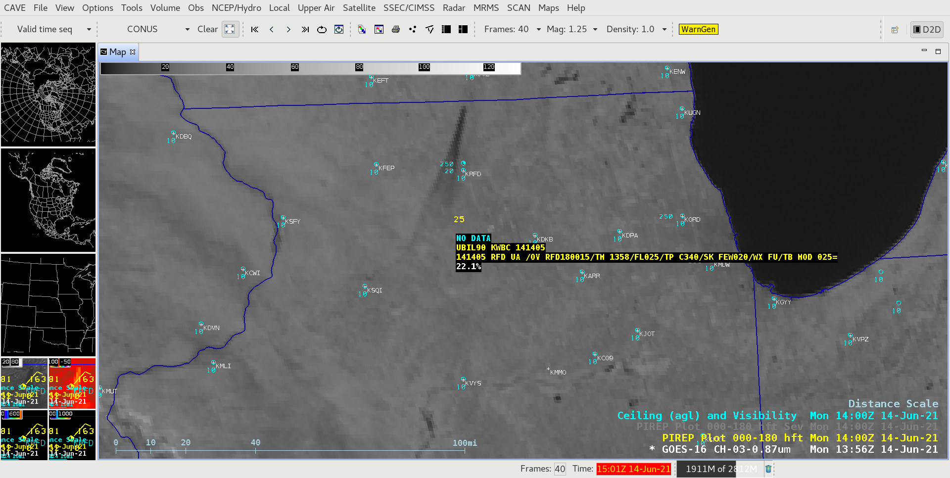
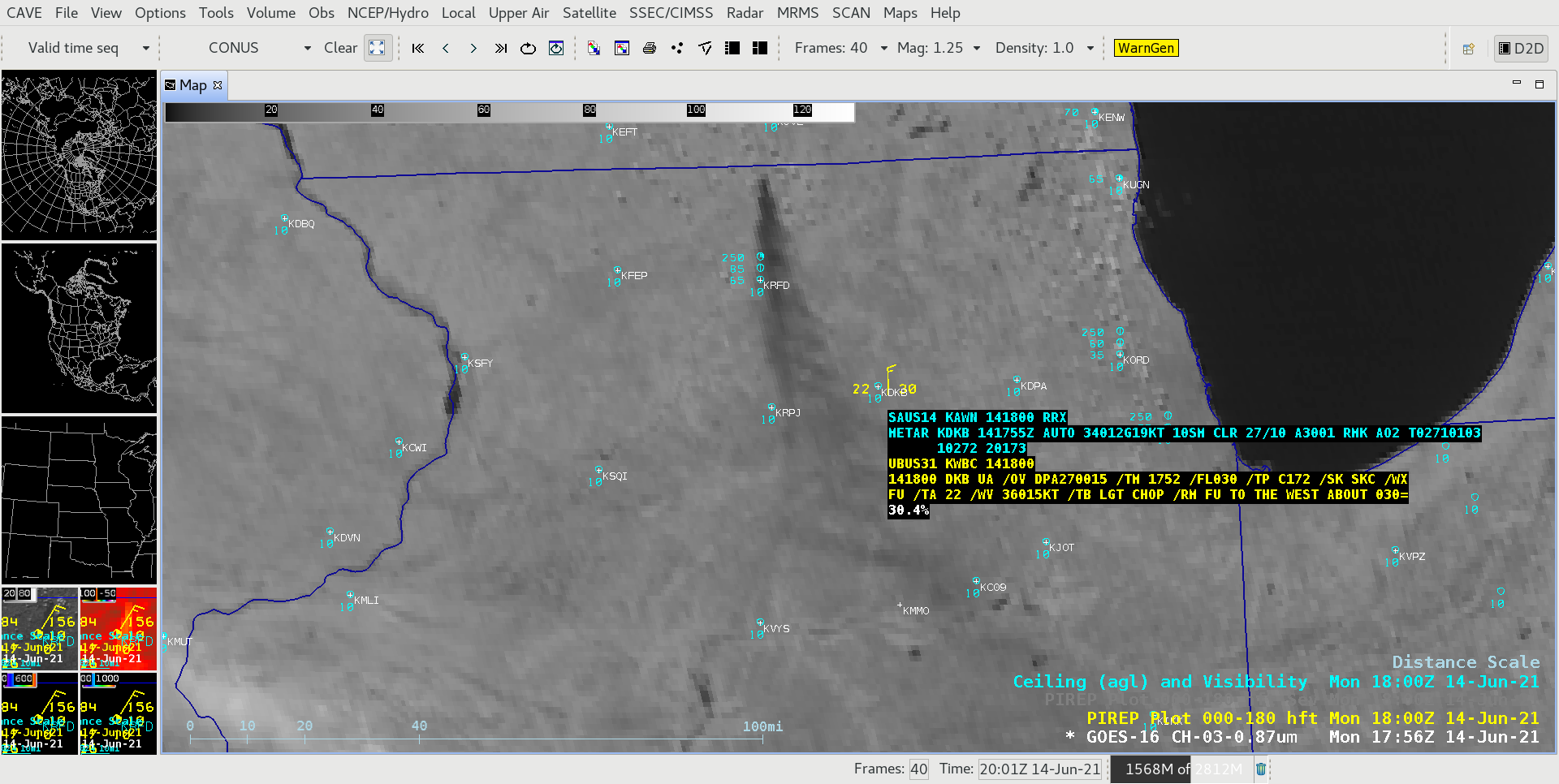
![GOES-16 Near-Infrared "Vegetation" (0.86 µm) image, with plots of pilot reports and airport ceilings and visibility [click to enlarge]](https://cimss.ssec.wisc.edu/satellite-blog/images/2021/06/210614_goes16_nearInfraredVegetation_IL_fire_smoke_plume_anim.gif)
GOES-16 Near-Infrared “Vegetation” (0.86 µm) images, with plots of pilot reports (yellow) and airport ceilings and visibility (cyan) [click to enlarge]
![GOES-16 Near-Infrared "Vegetation" (0.86 µm) images [click to play animation | MP4]](https://cimss.ssec.wisc.edu/satellite-blog/images/2021/06/GOES-16_RadC_C03_2021165_120000_2021165_192500.gif)
GOES-16 Near-Infrared “Vegetation” (0.86 µm) images (credit: Tim Schmit, NOAA/NESDIS) [click to play animation | MP4]
![GOES-16 "Red" Visible (0.64 µm) and Near-Infrared "Vegetation" (0.86 µm) images at 1516 UTC (credit: Tim Schmit, NOAA/NESDIS) [click to enlarge]](https://cimss.ssec.wisc.edu/satellite-blog/images/2021/06/GOES-16_ABI_RadC_C02_C03_2021165_151616Z.gif)
GOES-16 “Red” Visible (0.64 µm) and Near-Infrared “Vegetation” (0.86 µm) images at 1516 UTC (credit: Tim Schmit, NOAA/NESDIS) [click to enlarge]
![GOES-16 True Color RGB images [click to play animation | MP4]](https://cimss.ssec.wisc.edu/satellite-blog/images/2021/06/210614_goes16_trueColorRGB_IL_fire_smoke_plume_anim.gif)
GOES-16 True Color RGB images [click to play animation | MP4]
![GOES-16 Day Land Cloud RGB images [click to play animation | MP4]](https://cimss.ssec.wisc.edu/satellite-blog/images/2021/06/210614_goes16_dayLandCloudRGB_IL_fire_smoke_plume_anim.gif)
GOES-16 Day Land Cloud RGB images [click to play animation | MP4]
![GOES-16 Day Snow Fog RGB images [click to play animation | MP4]](https://cimss.ssec.wisc.edu/satellite-blog/images/2021/06/GOES-16_RadC_day_snow_fog_2021165_120000_2021165_192500.gif)
GOES-16 Day Snow Fog RGB images (credit: Tim Schmit/NOAA/NESDIS) [click to play animation | MP4]
#Sentinel2 was in the perfect place and time to capture some very hires images of the #RocktonFire #ChemToolFire / explosion yesterday. You can even see some of the bright flames. @UWCIMSS @CIMSS_Satellite @NWSChicago pic.twitter.com/ENykAY4Paf
— Remy Mermelstein | WeatherInTheHud (@WeatherInTheHud) June 15, 2021
Here is a look a the radar imagery of the chemical fire in Rockton, IL. The fire started around 7:25am this morning with a rather large explosion at roughly 9:35AM, which shows up very well with some very high reflectivities. #wiwx #swiwx pic.twitter.com/tu1yaLM7eG
— NWS Milwaukee (@NWSMilwaukee) June 14, 2021