Monitoring severe weather as it happens
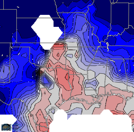
NUCAPS/MADIS Lifted Index, GLM Group Density, GOES-16 Band 13 Infrared Imagery, and ProbSevere polygons, all at ~0939 UTC on 17 March 2021 (Click to enlarge) All imagery from RealEarth
When NOAA’s Storm Prediction Center issues a High Risk of severe weather (below), people sit up and take notice. Are there easily accessible tools to monitor the state of the atmosphere in/around a region of expected severe weather?
The toggle above shows products (early in the morning on 17 March — at 439 AM CDT) in RealEarth that can help. NOAA-Unique Combines Atmospheric Processing System (NUCAPS)/MADIS (Meteorological Assimilation Data Ingest System) Lifted Indices combine tropospheric information from NUCAPS profiles with lower-tropospheric/surface information from MADIS to create Lifted Index fields, twice daily. These fields are generated using HEAP (Hyper-spectral Enterprise Algorithm Package) software (incorporated into CSPP — the Community Software Processing Package) at the UW-CIMSS Direct Broadcast site. A Suomi-NPP (or NOAA-20) overpass will quickly yield stability information. Today’s afternoon Suomi-NPP overpasses occurs around 1730 UTC (east of the High Risk area) and 1915 UTC (Link, from this site.) The toggle above also includes GOES-16 Band 13 infrared (Clean Window, 10.3 µm) information, GLM Group Density, and NOAA/CIMSS ProbSevere (ProbSevere has a stand-alone RealEarth-based site here). All of these products are useful in monitoring this evolving, dangerous event. As is often the case, the strongest convection was occurring at 0939 UTC along the edges of the most unstable air, that is, in the instability gradient.
People within the region of elevated risk of Severe Weather on 17 March 2021, especially the region High Risk, should pay especial attention to the weather.
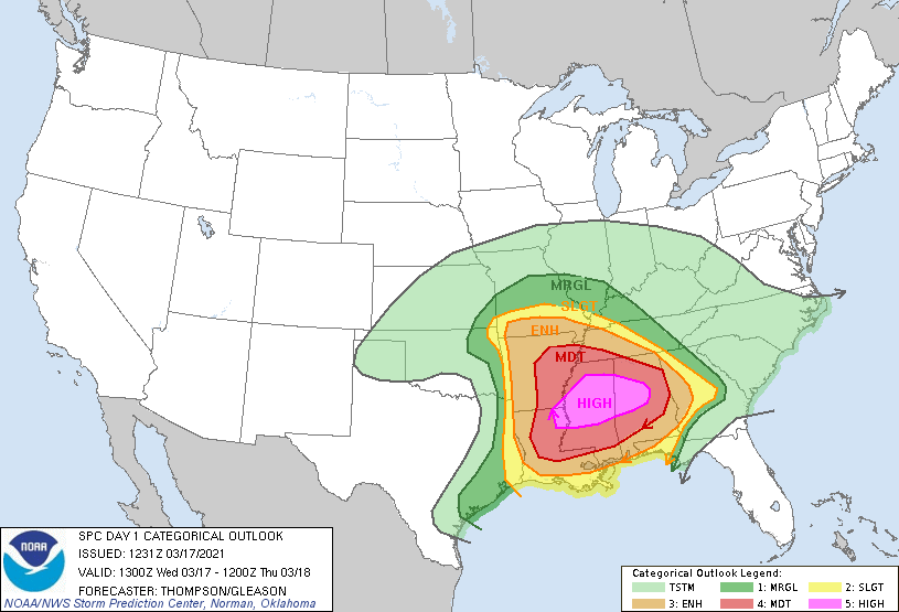
NOAA Storm Prediction Center Risk assessment for 17 March 2021, issued 1300 UTC on 17 March (Click to enlarge)
Added: the Geosphere site (link) gives rapid access to GOES-16 imagery (including mesoscale sectors) and can be used to monitor this evolving situation.
The afternoon image of stability is shown below.
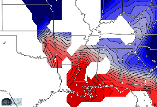
NUCAPS/MADIS Lifted Index, GLM Group Density, and GOES-16 Band 13 Infrared Imagery, all at ~1830 UTC on 17 March 2021 (Click to enlarge) All imagery from RealEarth