Topography effects: warm ridge tops, and chinook warming
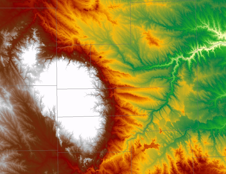
Not every part of the US was experiencing the wrath of winter on 26 January 2007 (see the previous Blog post); an AWIPS image of the 1-km resolution MODIS 11.0 µm InfraRed (“IR window”) channel (above) revealed an interesting distribution of brightness temperatures that were strongly influenced by the topography of the Black Hills region of western South Dakota. Matthew Bunkers (Science and Operations Officer at the Rapid City SD National Weather Service forecast office) provided a nice high-resolution topography image (below) and offered insight toward the interpretation of the MODIS IR image. The most obvious feature evident on the IR image was the zone of darker red enhancement (brightness temperature values of 0º to +10º C, or 32º to 50º F) seen along the northern and eastern periphery of the Black Hills — this was a result of westerly/southwesterly “chinook winds” to the lee of the highest terrain, where downslope winds were warming the air adiabatically (MODIS IR image with surface METAR reports). Several hours after this 04 UTC MODIS image, the temperature at Ellsworth Air Force Base (KRCA) rose from 39º F at 09 UTC to 50º F at 10 UTC, with northwesterly winds gusting to 25 knots (29 mph) in the wake of a cold frontal passage. Another item of interest to note on the MODIS IR image is the narrow filaments of warmer brightness temperatures (red enhancement) that extended from the foothills of the Black Hills eastward across the plains — this signature indicates that the ridge tops in that area remained well-mixed (due to higher wind speeds) and stayed relatively warm compared to the adjacent river valleys (which decoupled, and experienced stronger radiational cooling). Note that the winds were still light (around 5 knots) at Rapid City Regional Airport (KRAP) and Ellsworth Air Force Base (KRCA) at 04 UTC, prior to the arrival of the stronger post-frontal winds. The daytime winds eventually gusted to 47 knots (54 mph) at the Rapid City airport, which prompted the issuance of an air pollution alert for blowing dust in Rapid City (a MODIS true color image from later that day showed that there was no snow on the ground in the Rapid City area and the eastern foothills — only the higher elevations of the northern and western Black Hills still had some residual snow pack). While the corresponding 4-km resolution GOES-12 IR imagery did show the “chinook warming” signature to the lee of the Black Hills, the smaller scale details such as the warmer ridge tops were not apparent.


