PyroCumulonimbus cloud in Australia
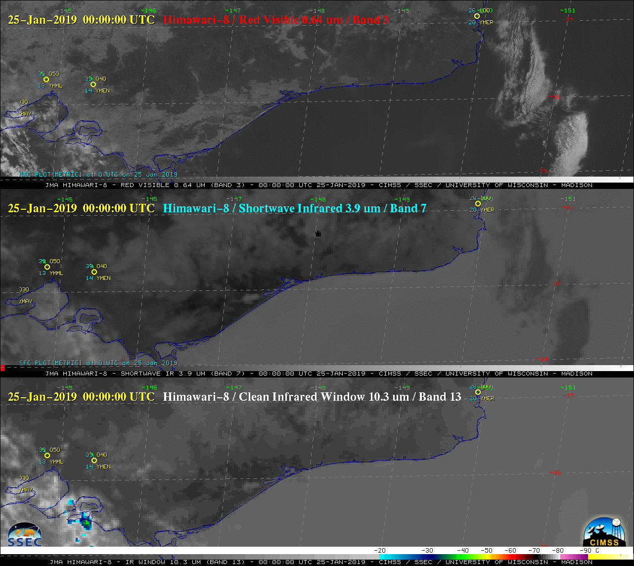
Himawari-8 “Red” Visible (0.64 µm, top), Shortwave Infrared (3.7 µm, middle) and Infrared Window (10.3 µm, bottom) images [click to play to animation | MP4]
A closer view of Himawari-8 “Red” Visible (0.64 µm) and Shortwave Infrared (3.7 µm) images (below) revealed the rapid southeastward run of the fire, as shown by the growth of the “hot spot” (black to red pixels) on Shortwave Infrared images. The darker gray appearance of the pyroCb cloud is due to the presence of smaller ice crystals at the cloud top — these smaller ice crystals are more efficient reflectors of incoming solar radiation, making the cloud tops appear warmer than those of conventional cumulonimbus. Vigorous updrafts driven by the intense heat of the fire limit the in-cloud residence time for ice crystal growth, which leads to smaller particles being ejected at the pyroCb cloud top.
![Himawari-8 "Red" Visible (0.64 µm, left) and Shortwave Infrared (3.7 µm, right) images [click to play to animation | MP4]](https://cimss.ssec.wisc.edu/satellite-blog/wp-content/uploads/sites/5/2019/01/190125_himawari8_visible_shortwaveInfrared_Australia_pyrocb_anim.gif)
Himawari-8 “Red” Visible (0.64 µm, left) and Shortwave Infrared (3.7 µm, right) images [click to play to animation | MP4]
![VIIRS True Color RGB and Infrared Window (11.45 µm) images from Suomi NPP (0311 UTC) and NOAA-20 (0501 UTC) images [click to enlarge]](https://cimss.ssec.wisc.edu/satellite-blog/wp-content/uploads/sites/5/2019/01/190125_suomiNPP_noaa20_viirs_truecolor_infrared_Australia_pyroCb_anim.gif)
VIIRS True Color RGB and Infrared Window (11.45 µm) images from Suomi NPP (0311 UTC) and NOAA-20 (0501 UTC) images [click to enlarge]
Large bushfire in #EastGippsland producing a huge plume of smoke this afternoon stretching over eastern Bass Strait. Check out the satellite picture at https://t.co/9md40P2b4k pic.twitter.com/5ceZV5nf0T
— Bureau of Meteorology, Victoria (@BOM_Vic) January 25, 2019