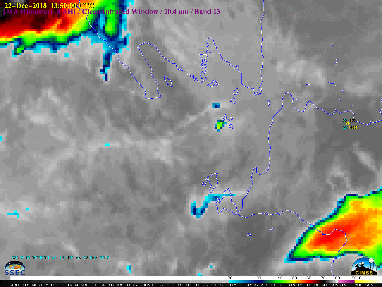
Eruption of the Anak Krakatau volcano in Indonesia
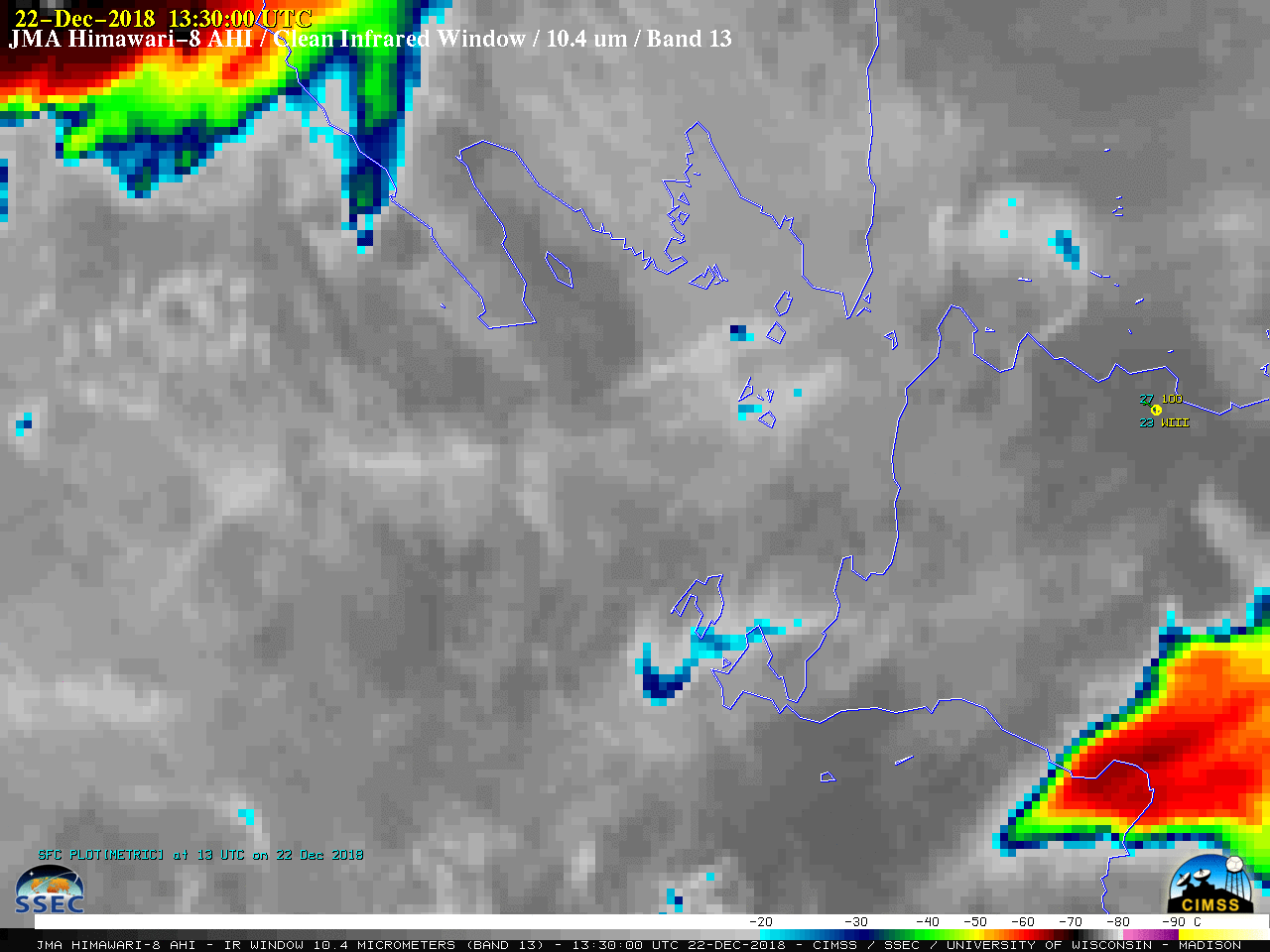
Himawari-8 “Clean” Infrared Window (10.4 µm) images, with hourly plots of surface reports from Jakarta (station identifier WIII) [click to play animation | MP4]
![Plots of rawinsonde data from Jakarta, Indonesia [click to enlarge]](https://cimss.ssec.wisc.edu/satellite-blog/wp-content/uploads/sites/5/2018/12/181222_181223_WIII_RAOBS.GIF)
Plots of rawinsonde data from Jakarta, Indonesia [click to enlarge]
![Himawari-8 "Red" Visible (0.64 µm) images. with hourly plots of surface reports [click to play animation | MP4]](https://cimss.ssec.wisc.edu/satellite-blog/wp-content/uploads/sites/5/2018/12/181222_himawari8_visible_Krakatoa_anim.gif)
Himawari-8 “Red” Visible (0.64 µm) images, with hourly plots of surface reports from Jakarta (station identifier WIII) [click to play animation | MP4]
![Himawari-8 Ash Height retrievals [click to play animation]](https://cimss.ssec.wisc.edu/satellite-blog/wp-content/uploads/sites/5/2018/12/181222_himawari8_ash_height_Krakatoa_anim.gif)
Himawari-8 Ash Height retrievals [click to play animation]
![Himawari-8 Ash Loading retrievals [click to play animation]](https://cimss.ssec.wisc.edu/satellite-blog/wp-content/uploads/sites/5/2018/12/181222_himawari8_ash_loading_Krakatau_anim.gif)
Himawari-8 Ash Loading retrievals [click to play animation]
![NOAA-20 VIIRS True Color RGB and Infrared Window (11.45 µm) images at 0610 UTC [click to enlarge]](https://cimss.ssec.wisc.edu/satellite-blog/wp-content/uploads/sites/5/2018/12/181223_0610utc_noaa20_viirs_truecolor_infrared_Anak_Krakatau_anim.gif)
NOAA-20 VIIRS True Color RGB and Infrared Window (11.45 µm) images at 0610 UTC [click to enlarge]
![Infrared Window images from NOAA-20 VIIRS (11.45 µm) and Himawari-8 AHI (10.4 µm) [click to enlarge]](https://cimss.ssec.wisc.edu/satellite-blog/wp-content/uploads/sites/5/2018/12/181223_0610utc_noaa20_himawari8_infrared_Anak_Krakatau_anim.gif)
0610 UTC Infrared Window images from NOAA-20 VIIRS (11.45 µm) and Himawari-8 AHI (10.4 µm) [click to enlarge]
#Krakatoa/#Krakatau #lightning update: Rough counts have had peak values of 90 lightning events per minute detected around the volcano! Between ~1430 UTC 22 Dec and ~1900 UTC 23 Dec, there have been tens of thousands of lightning events detected by GLD360. pic.twitter.com/iekphVjsD2
— Chris Vagasky (@COweatherman) December 23, 2018
Here’s the @WWLLN lightning strike detection map for #Krakatau on Dec 23: 10856 strokes. Remarkable. pic.twitter.com/6xxdYSgjmu
— Simon Carn (@simoncarn) December 24, 2018
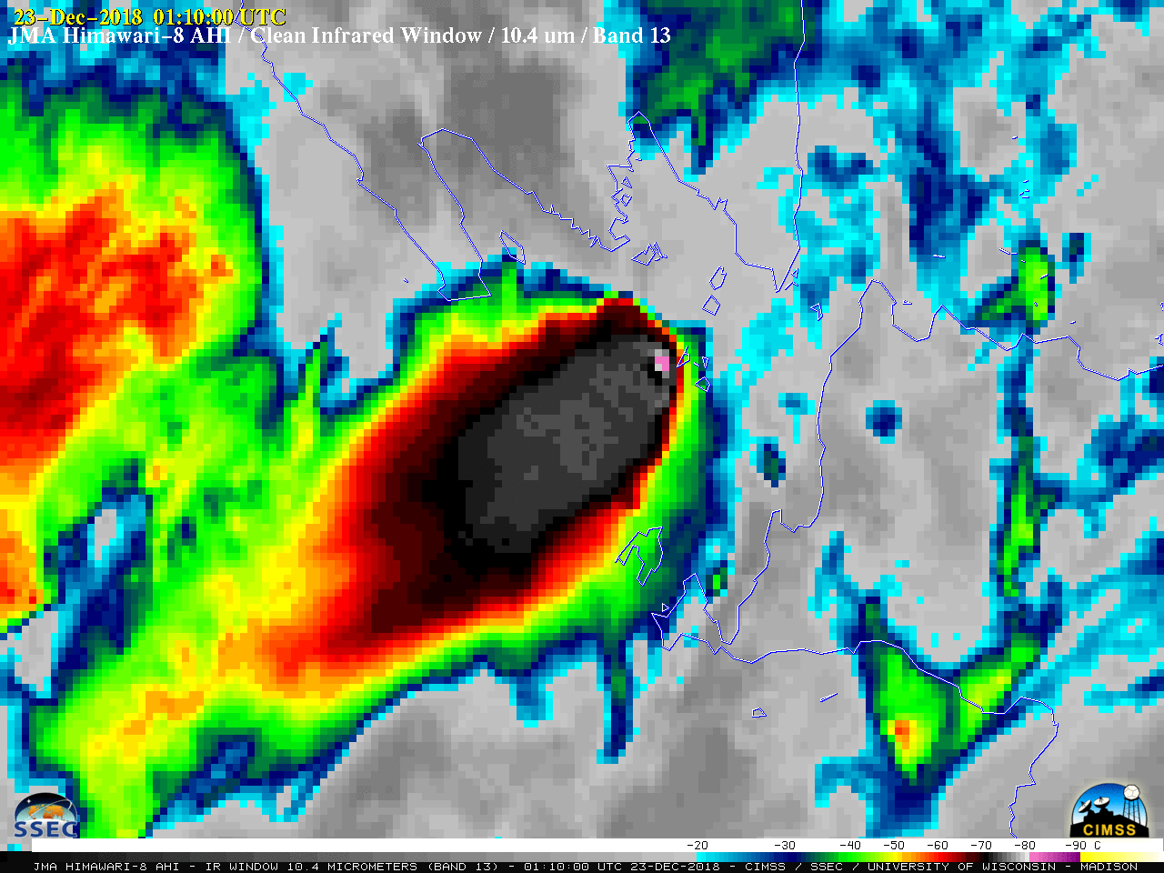
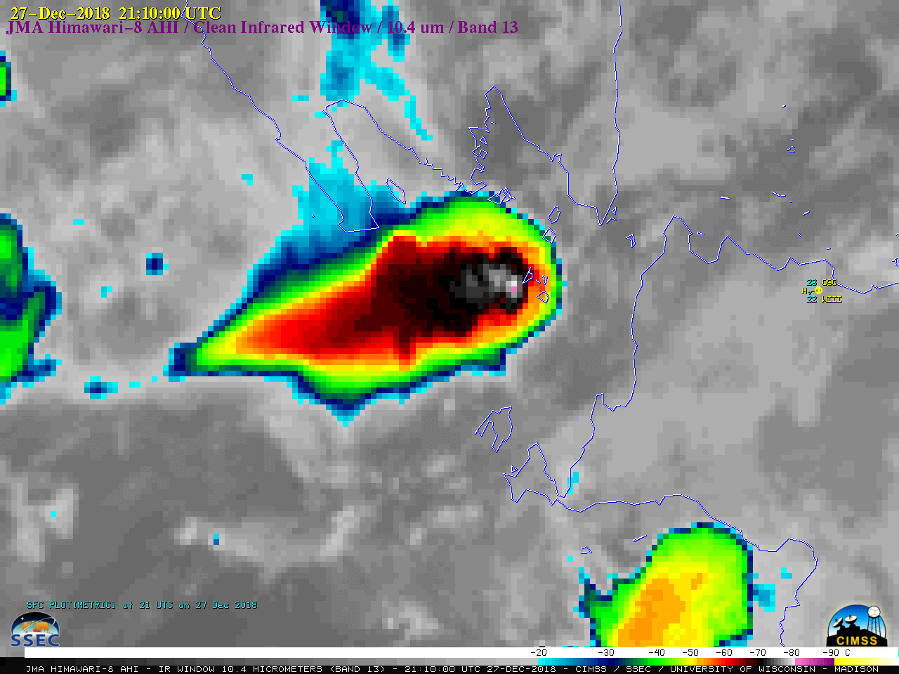
A comparison of Himawari-8 Visible and Infrared images showed the persistent volcanic cloud following sunrise on 23 December (below). The pulsing overshooting tops continued to exhibit infrared brightness temperatures as cold as -80ºC at times.
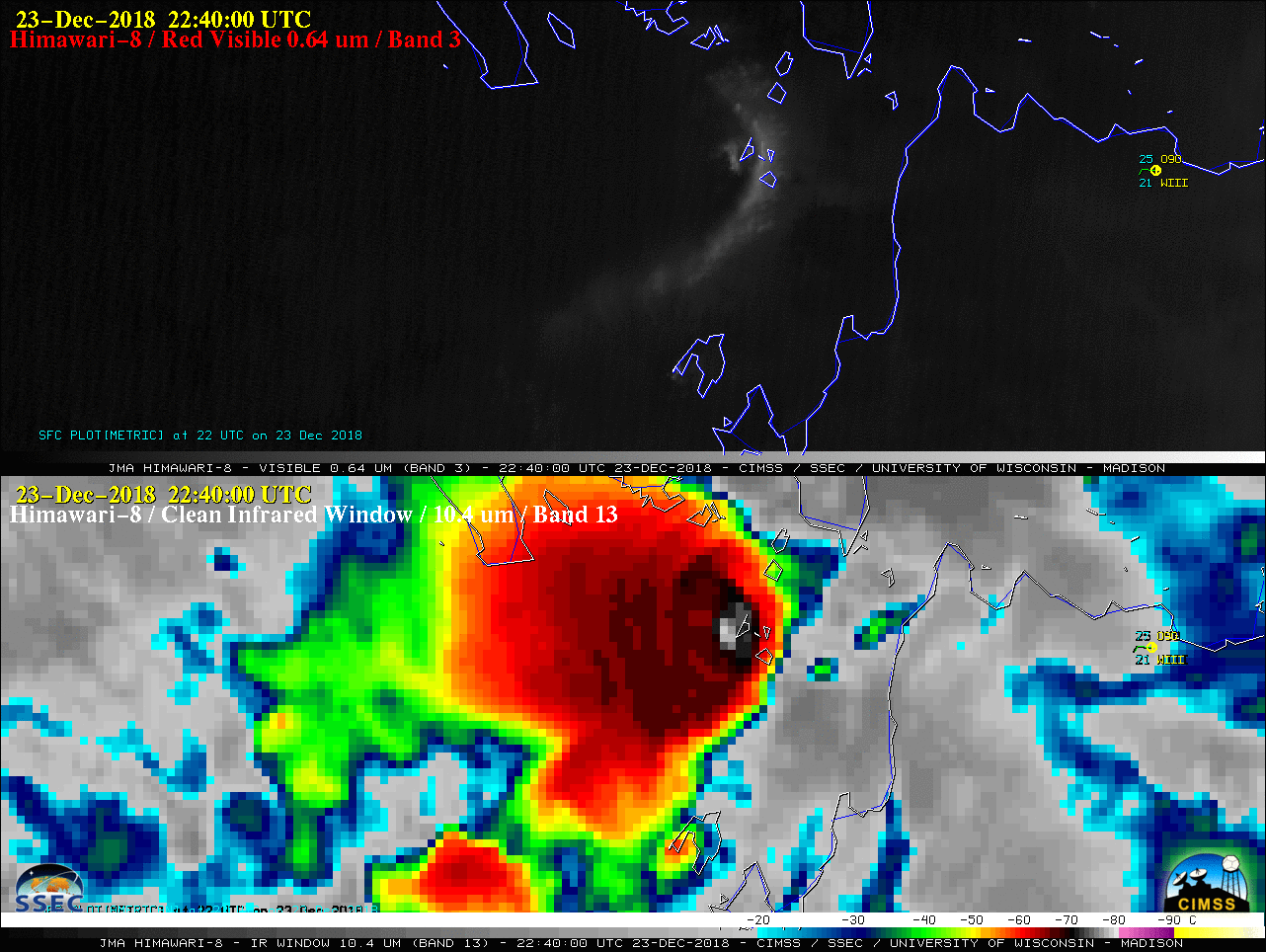
Himawari-8 “Red” Visible (0.64 µm, top) and “Clean” Infrared Window (10.4 µm, bottom) images [click to play animation | MP4]
===== 24 December Update =====
![NOAA-20 VIIRS True Color RGB and Infrared Window (11.45 µm) images [click to enlarge]](https://cimss.ssec.wisc.edu/satellite-blog/wp-content/uploads/sites/5/2018/12/181224_0550utc_noaa20_viirs_truecolor_infrared_Anak_Krakatau_anim.gif)
NOAA-20 VIIRS True Color RGB and Infrared Window (11.45 µm) images [click to enlarge]
A long animation of Himawari-8 “Clean” Infrared Window (10.4 µm) images spanning over 48 hours from the onset of the eruption (below) showed the remarkably persistent volcanic cloud, with pulsing overshooting tops anchored over Anak Krakatau.

Himawari-8 “Clean” Infrared Window (10.4 µm) images, with hourly surface report plots from Jakarta WIII {click to play animation | MP4]
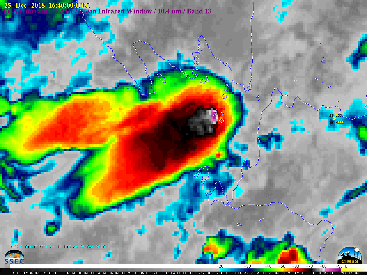
===== 25 December Update =====
![NOAA-20 VIIRS True Color RGB and Infrared Window (11.45 µm) images [click to enlarge]](https://cimss.ssec.wisc.edu/satellite-blog/wp-content/uploads/sites/5/2018/12/181225_0710utc_noaa20_viirs_truecolor_infrared_Anak_Krakatau_anim.gif)
NOAA-20 VIIRS True Color RGB and Infrared Window (11.45 µm) images [click to enlarge]
The coldest pixels on another NOAA-20 VIIRS Infrared image at 1810 UTC (below) were still within the -80 to -87ºC range.
![NOAA-20 VIIRS Infrared Window (11.45 µm) image [click to enlarge]](https://cimss.ssec.wisc.edu/satellite-blog/wp-content/uploads/sites/5/2018/12/181225_1810utc_noaa20_viirs_infrared_Anak_Krakatau.png)
NOAA-20 VIIRS Infrared Window (11.45 µm) image [click to enlarge]
Himawari-8 “Clean” Infrared Window (10.4 µm) images, 22-25 December [click to play MP4 animation]
===== 28 December Update =====
![Himawari-8 "Clean" Infrared Window (10.4 µm) images, 22-28 December [click to play MP4 animation]](https://cimss.ssec.wisc.edu/satellite-blog/wp-content/uploads/sites/5/2018/12/HIM08_IR_KRAKATOA_22_28DEC2018_2018362_010000_HIMAWARI-8_0001PANEL.GIF)
Himawari-8 “Clean” Infrared Window (10.4 µm) images, 22-28 December [click to play MP4 animation]
NOAA-20 captured one of the final convective pulses around 0620 UTC on 28 December (below), when the coldest cloud tops were in the -50 to -55ºC range (yellow to orange enhancement).
![NOAA-20 VIIRS True Color RGB and Infrared Window (11.45 µm) images [click to enlarge]](https://cimss.ssec.wisc.edu/satellite-blog/wp-content/uploads/sites/5/2018/12/181228_0620utc_noaa20_viirs_truecolor_infrared_Anak_Krakatau_anim.gif)
NOAA-20 VIIRS True Color RGB and Infrared Window (11.45 µm) images [click to enlarge]
Here it is…a loop of #lightning from 2:30am MT 22 Dec until 2:30am MT 28 December from #Krakatau/#Krakatoa detected by GLD360. A truly incredible event. pic.twitter.com/nvStqoMaAC
— Chris Vagasky (@COweatherman) December 28, 2018