Blowing dust from the Copper River Valley in Alaska
![NOAA-20 VIIRS True Color RGB images [click to enlarge]](https://cimss.ssec.wisc.edu/satellite-blog/wp-content/uploads/sites/5/2018/10/181031_181101_noaa20_viirs_truecolor_AK_dust_anim.gif)
NOAA-20 VIIRS True Color RGB images [click to enlarge]
A comparison of Suomi NPP VIIRS Visible (0.64 µm), Shortwave Infrared (3.74 µm) and Infrared Window (11.45 µm) images (below) showed the plume at 2022 UTC on 01 November. The map overlay has been removed from one set of images, to better reveal the dust plume source region. Note that the plume appeared much warmer (darker shades of red) in the Shortwave Infrared image — this is due to enhanced solar reflectance off the small dust particles. Since airborne dust is generally transparent at longer infrared wavelengths, only the thickest portion of the plume exhibited a subtle signature on the 11.45 µm image.
![Suomi NPP VIIRS Visible (0.64 µm), Shortwave Infrared (3.74 µm) and Infrared Window (11.45 µm) images [click to enlarge]](https://cimss.ssec.wisc.edu/satellite-blog/wp-content/uploads/sites/5/2018/10/181101_2022utc_suomi_npp_viirs_visible_shortwaveInfrared_infraredWindow_AK_dust_anim.gif)
Suomi NPP VIIRS Visible (0.64 µm), Shortwave Infrared (3.74 µm) and Infrared Window (11.45 µm) images [click to enlarge]
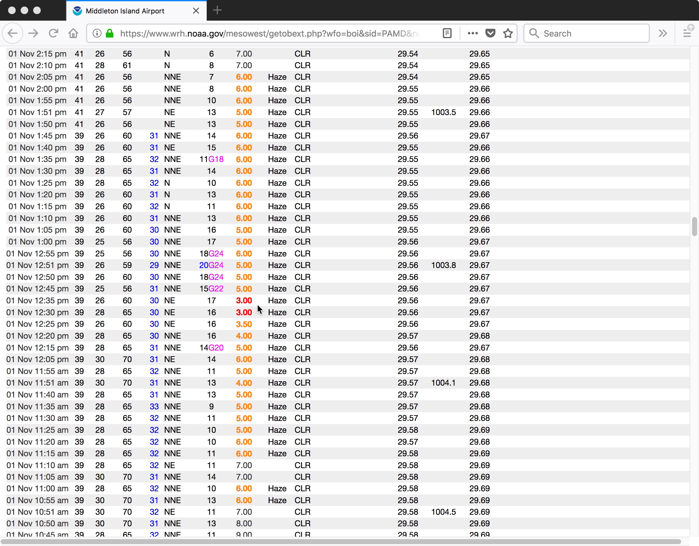
![Time series plot of surface observations at Middleton Island [click to enlarge]](https://cimss.ssec.wisc.edu/satellite-blog/wp-content/uploads/sites/5/2018/10/181101_PAMD_SFCMG.GIF)
Time series of surface observations at Middleton Island [click to enlarge]
![Metop-A and Metop-B ASCAT surface scatterometer winds [click to enlarge]](https://cimss.ssec.wisc.edu/satellite-blog/wp-content/uploads/sites/5/2018/11/181101_meteop_ascat_AK_dust_anim.gif)
Metop-A and Metop-B ASCAT surface scatterometer winds [click to enlarge]
![Suomi NPP VIIRS Visible (0.64 µm) and Infrared Brightness Temperature Difference (11-12 µm) images [click to enlarge]](https://cimss.ssec.wisc.edu/satellite-blog/wp-content/uploads/sites/5/2018/10/181101_2204utc_suomi_npp_viirs_visible_infraredBTD_AK_dust_anim.gif)
Suomi NPP VIIRS Visible (0.64 µm) and Infrared Brightness Temperature Difference (11-12 µm) images [click to enlarge]
![VIIRS Aerosol Optical Thickness product [click to enlarge]](https://cimss.ssec.wisc.edu/satellite-blog/wp-content/uploads/sites/5/2018/10/181031_181101_viirs_aerosolOpticalThickness_AK_anim.gif)
VIIRS Aerosol Optical Thickness product [click to enlarge]
![GOES-15 Visible (0.63 µm) images [click to play animation]](https://cimss.ssec.wisc.edu/satellite-blog/wp-content/uploads/sites/5/2018/10/181101_goes15_visible_AK_anim.gif)
GOES-15 Visible (0.63 µm) images [click to play animation]